
The Great Wall of China is not one wall but a network of fortifications totalling 21,196 km, built and rebuilt in separate campaigns between roughly the 7th century BCE and the 17th century CE, with the surviving brick-and-stone sections most visitors see dating from the Ming dynasty (1368–1644) rather than from Qin Shi Huang's era. It was inscribed as a UNESCO World Heritage Site in 1987, and roughly a third of it has already disappeared.
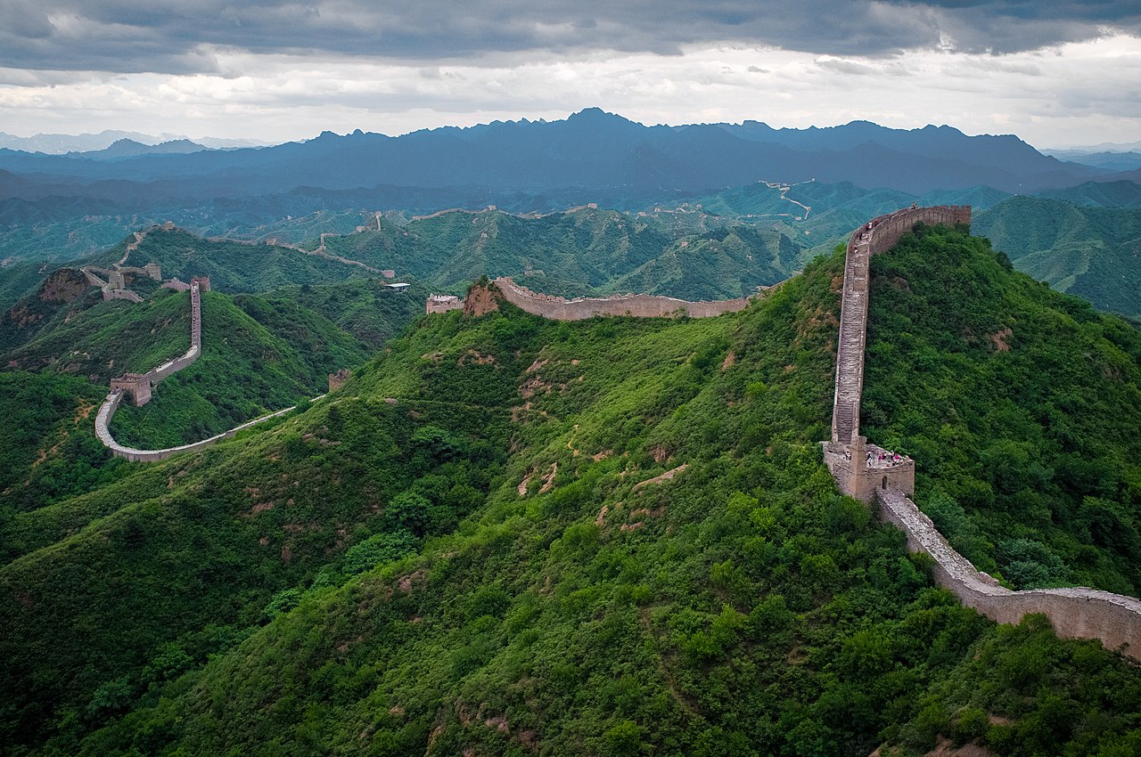
The 21,196 km Figure and What It Actually Counts
The precise-sounding total comes from a survey by China's State Administration of Cultural Heritage and the National Bureau of Surveying, published in 2012 after five years of fieldwork using GPS and remote sensing.
Critically, it counts every identified segment from every period, including walls built centuries apart and hundreds of kilometres from one another, plus trenches, natural barriers incorporated into the defensive line, and around 25,000 watchtowers. Sum all of it and you get 21,196 km. The Ming wall alone — the continuous, well-built line across northern China — measures about 8,850 km, and the section in reasonable condition is far shorter still.
This is why older sources gave figures of 6,000 or 8,850 km: they were counting different things. None is wrong, but the 21,196 km number describes a scattered archaeological complex spanning fifteen provinces, not a single structure anyone could walk end to end.
It also disposes of the persistent claim that the wall is visible from the Moon or from space with the naked eye. It is not. At a typical width of 5–8 m it is far narrower than a motorway, and it is built from local materials that match the surrounding terrain in colour. Chinese astronaut Yang Liwei confirmed after his 2003 flight that he could not see it.
Walls Before the Great Wall
The earliest fortifications long predate a unified China. During the Warring States period (475–221 BCE), rival states including Qi, Yan, Zhao and Wei each built defensive walls of rammed earth — some against northern nomads, others against each other.
When Qin Shi Huang unified China in 221 BCE, he ordered his general Meng Tian to connect and extend the northern walls of the conquered states into a single line, demolishing those that had divided the interior. Contemporary accounts describe conscripted labour on an enormous scale, with soldiers, convicts and peasants dying in large numbers — the basis for the enduring legend of Meng Jiangnü, whose weeping is said to have collapsed a section to reveal her husband's bones.
Almost nothing of the Qin wall survives visibly, because it was rammed earth built along a line well north of the later Ming wall. The Han dynasty (206 BCE–220 CE) extended fortifications far west into the Gansu corridor to protect Silk Road trade, and Han-era earthen walls and beacon towers still stand in the dry Gobi margins, preserved by the desert climate. The Northern Wei, Northern Qi and Sui all built further walls; the Tang and Song largely did not, relying on other strategies.
Why the Ming Built in Brick
The wall as most people picture it — crenellated, brick-faced, marching along ridgelines — is a Ming project, and it was a response to a specific defeat.
In 1449, at the Tumu Crisis, Mongol forces under Esen Taishi routed a Ming army and captured the Zhengtong Emperor. The shock pushed the dynasty toward static defence, and over the following two centuries the Ming built the most elaborate wall system in Chinese history, organised into nine defence commands, or zhen, each responsible for a stretch.
Ming engineering marked a genuine advance. Where earlier walls were rammed earth — layers of soil compacted in wooden forms — the Ming faced their walls in fired brick and quarried stone set with lime mortar, over an earth and rubble core. Popular accounts claim sticky rice was added to the mortar; researchers have since confirmed that rice-based amylopectin was used in some Chinese lime mortars, producing a composite of unusual durability.
A typical Ming section stands 6–7 m high and 4–5 m wide at the top — sufficient for troops to march along, which made the wall a communications route as much as a barrier. Watchtowers were placed within sight of each other, and beacon towers relayed signals using smoke by day and fire by night, with the number of columns indicating enemy strength. A message could reportedly cross hundreds of kilometres in a matter of hours.
Following the Ridgelines: The Wall's Geography
The Ming wall runs from Hushan in Liaoning province near the Korean border west to Jiayuguan in Gansu, crossing Hebei, Beijing, Tianjin, Shanxi, Inner Mongolia, Shaanxi and Ningxia along the way.
Its route is not arbitrary. It follows, with reasonable fidelity, the ecological transition between the settled agricultural lands of the North China Plain and the steppe grasslands to the north — roughly the 400 mm annual rainfall line, below which rain-fed farming becomes unviable. The wall marks where an agrarian empire's territory ended and a pastoral nomadic economy began, which is why it sits where it does rather than at a river or mountain crest.
Within that corridor, builders followed a doctrine set out in classical military texts: use the terrain. The wall climbs to ridgelines and clings to them, uses cliffs and gorges as natural barriers where they exist, and concentrates masonry at passes. Materials were local — brick and stone in the well-supplied east near Beijing, rammed earth and even layered reed and gravel in the arid west.
Key passes anchor the system: Shanhaiguan, where the wall meets the Bohai Sea at the "First Pass Under Heaven"; Juyongguan and Badaling guarding the approaches to Beijing; and Jiayuguan, the western terminus at the edge of the desert, historically the point beyond which exiles passed out of China proper. The regional setting is covered further in the China geography guide.
Did It Work?
The wall's military record is more nuanced than either the triumphal or the dismissive account allows.
As an absolute barrier it clearly failed at the decisive moments. The Mongols under Genghis Khan and later Kublai Khan breached the Jin-era defences in the thirteenth century and ruled China as the Yuan dynasty. In 1644 the Ming wall was not overcome by assault at all: the general Wu Sangui, commanding at Shanhaiguan and facing a rebel army that had already taken Beijing, opened the gate and let the Manchus through. The Qing dynasty that followed had no use for the wall, since its territory extended well north of it, and maintenance essentially ceased.
But as day-to-day infrastructure it worked well. It was never intended to stop a determined army indefinitely — only to prevent the fast, small-scale raiding that was the normal pattern of steppe warfare. Mounted raiders could not easily take livestock and captives back over a 7 m wall, and garrisons could concentrate at threatened points because beacons gave warning. The wall also functioned as a customs and border-control line, regulating trade and taxing caravans, and as a road for moving troops and supplies laterally.
Judged as a raid-suppression and border-management system rather than an impenetrable shield, it did roughly what its builders asked of it — at a cost in labour and treasure that contributed to imperial strain.
The Great Wall Compared With Hadrian's Wall
Hadrian's Wall, built from 122 CE across northern Britain, invites the obvious comparison, and the differences are as instructive as the similarities.
Scale first: Hadrian's Wall runs 117 km, against 8,850 km for the Ming wall alone — roughly one seventy-fifth the length. It stood about 4–5 m high and up to 3 m wide, garrisoned by perhaps 10,000 auxiliary troops, where Ming garrison strength ran into the hundreds of thousands. Rome built its wall in about six years; China built and rebuilt its walls across nearly two millennia.
Structurally they are more alike than not. Both used local stone, both placed towers at regular intervals — Hadrian's Wall had a milecastle every Roman mile with two turrets between — and both concentrated defence at gates controlling movement. Both followed terrain, Hadrian's Wall running spectacularly along the Whin Sill escarpment much as the Ming wall follows ridgelines.
The deeper similarity is purpose. Neither was primarily meant to stop an invasion. Hadrian's Wall regulated movement, collected customs and suppressed raiding on a frontier Rome had decided not to push further north — the Historia Augusta says it was built to separate Romans from barbarians. Both marked an imperial decision that expansion had reached its economic limit: for Rome, the point where conquest stopped paying; for Ming China, the line where farmland gave way to steppe.
Both also outlived their function to become quarries. Hadrian's Wall supplied stone for local farms and roads for centuries, and Chinese villagers removed wall brick for houses and animal pens well into the modern era — one reason roughly 30% of the Ming wall has vanished and much of the remainder is unrestored rubble.
What survives is best understood as a two-thousand-year archaeological record of one recurring strategic problem — how a settled agricultural empire manages a long open frontier with mobile neighbours — rather than as a single monument. The restored sections near Beijing are the exception; most of the wall is eroding earth on a remote hillside.
