
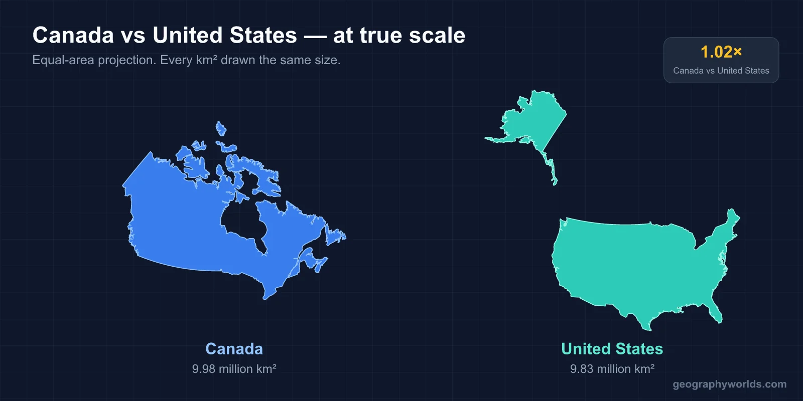
Yes. Canada is slightly larger than the United States. Canada covers 9,984,670 km² while the US covers 9,833,520 km². Canada is about 1.5% larger — by 151,150 km², which is roughly the size of Tunisia or Bangladesh. Canada is the 2nd-largest country in the world; the US is the 3rd or 4th, depending on how China's claims are counted.
The Short Answer
Canada and the US are the two largest countries in North America and two of the largest on Earth. The gap between them in total area is surprisingly small — just 1.5% — but it's consistent across most measurements. Canada is bigger because of its vast Arctic territory (Nunavut alone is 2.09 million km², larger than Mexico) and its enormous boreal forest belt stretching across the country.
If you compared just the contiguous portions of each country, the US would win — the contiguous US is 8.11 million km² vs Canada's 7.62 million km² of land south of 70°N. Canada's extreme northern territories tilt the comparison in its favor. The two countries are remarkably close in total area but very different in habitable area.

The Real Numbers
- Canada total area: 9,984,670 km² (3,855,103 sq mi)
- United States total area: 9,833,520 km² (3,796,742 sq mi)
- Difference: 151,150 km² — about the size of Tunisia, Bangladesh, or Nepal
- Ratio: Canada is about 1.015× the size of the US (barely larger)
By comparison, the gap between Canada (#2) and Russia (#1, at 17.1 million km²) is about 7.1 million km² — nearly the size of the contiguous US. Russia is in a league of its own. The US, China (9.60M), Canada (9.98M) are all clustered in the 9.5-10 million km² range — the top tier outside of Russia.
Population: A Huge Gap
While the size comparison is nearly even, the population comparison is dramatic:
- US population: ~333,000,000
- Canada population: ~40,000,000
- US density: ~36 people per km²
- Canada density: ~4 people per km²
The US has about 8.3× more people than Canada, despite having only 1.5% less land. US population density is about 9× higher than Canada's. Canada's low density reflects the fact that its vast northern territories are nearly empty — Nunavut has 39,000 people in 2.09 million km², a density of 0.019 people/km², among the lowest in the world.
The 90% Rule
About 90% of Canada's population lives within 160 km (100 miles) of the US border. The southern strip of Canada — from Vancouver to Halifax — contains nearly all the major cities (Toronto, Montreal, Vancouver, Calgary, Edmonton, Ottawa, Winnipeg) and the bulk of the population. The northern 80% of Canada's land area holds maybe 5% of its people.
The US has a more distributed population. While the East Coast and West Coast hold the most people, there are major cities throughout the Midwest, South, and West. The US has cities every 200-500 km in most of the country; Canada has cities every 200-500 km along its southern strip, then almost nothing for the next 2,000-3,000 km north.
Economy: The US Dominates
The US economy is roughly 13× the size of Canada's:
- US GDP: ~$26.9 trillion
- Canada GDP: ~$2.14 trillion
- US per capita GDP: ~$80,000
- Canada per capita GDP: ~$53,000
The US has the world's largest economy. Canada has the 9th- or 10th-largest. Per capita, the US is about 50% richer on average. But Canada has higher per-capita household wealth in some measurements due to a more equitable wealth distribution, universal healthcare, and lower private health expenses.
Climate and Geography
Canada is dominated by cold climates. About 89% of Canada's land has a continental, subarctic, or arctic climate. Only the southernmost areas (BC, southern Ontario, the Maritimes) have truly temperate climates. The North is permanently frozen permafrost zone — about 50% of Canada has permafrost beneath the surface.
The US has more climate diversity. The contiguous US ranges from arctic tundra (northern Maine, Wisconsin, Minnesota) to subtropical (Florida, Hawaii). It has deserts, prairies, temperate forests, alpine zones, and tropical zones. Alaska adds another extreme — arctic tundra and boreal forest. The US has a much wider temperature range across its territory than Canada does.
The Border
The US-Canada border is the longest international border in the world — 8,891 km (5,525 miles) of undefended frontier. It runs roughly along the 49th parallel west of Lake Superior, but is more complex in the east. The border passes through dense forest in the Maritimes, the Great Lakes water boundary, the prairies of Montana/Saskatchewan, the Rockies, and the temperate rainforests of British Columbia and Washington.
About 400,000 people cross the US-Canada border each day, making it one of the busiest crossing points in the world. Despite NAFTA (now USMCA), occasional disputes flare up over trade, fishing rights, and softwood lumber. But fundamentally the relationship is the closest bilateral relationship on Earth.
Time Zones
Both countries span 6 time zones. The US has Pacific, Mountain, Central, Eastern, Alaska, and Hawaii-Aleutian. Canada has Pacific, Mountain, Central, Eastern, Atlantic, and Newfoundland (which is uniquely offset by 30 minutes — Newfoundland is the only Canadian or US zone that's not aligned to a whole hour). Newfoundland time is UTC-3:30, while Atlantic time is UTC-4. This makes Newfoundland one of the few places in the world with a non-hour-aligned time zone.
The two countries align their time zones for practical purposes — Eastern time in NYC matches Toronto, Montreal, and Halifax. Pacific time in LA matches Vancouver.
Provinces vs States
Canada has 10 provinces and 3 territories — 13 total subnational divisions. The largest by area is Nunavut (2,093,190 km²). The most populous is Ontario (15.6 million people). The US has 50 states. The largest by area is Alaska (1,723,337 km²). The most populous is California (39 million).
Canada's federal structure gives provinces more autonomy than US states have in some areas (especially healthcare and natural resources). But the underlying federal-state vs federal-province division of powers is similar in both countries.
Coastlines
Canada has the longest coastline of any country in the world — about 202,080 km, including its massive Arctic archipelago. This is more than 6× the length of Russia's coastline and about 10× longer than the US coastline (19,924 km). Most of Canada's coast is in the high Arctic, where ice covers it much of the year, but it's still officially coastline.
The US has a more accessible and economically active coastline — Atlantic, Pacific, Gulf of Mexico, and Arctic. Major US ports (Los Angeles, Long Beach, Houston, New York, Savannah) handle a vastly higher volume of trade than Canada's ports (Vancouver, Montreal, Halifax). Coastline length is one metric; coastal economic activity is another, and the US wins decisively on the second.
Key Facts
- Canada is about 1.5% larger than the US.
- The US has 8.3× more people than Canada.
- 90% of Canadians live within 160 km of the US border.
- Canada is the 2nd-largest country; the US is the 3rd-4th.
- The US-Canada border is the longest international border in the world.
- Canada has the longest coastline of any country (~202,080 km).
Fun Facts
- Canada has more lakes than the rest of the world combined — about 879,800 lakes larger than 0.1 km².
- The Canadian province of Quebec alone (1,667,441 km²) is bigger than Alaska, France, Spain, and Germany combined.
- If you removed Russia from the comparison, Canada would be the largest country in the world.
- The US has more national parks (63) than Canada (38), despite Canada having more total land.
- The boundary between Canada and the US is technically the 49th parallel — but only west of the Great Lakes. East of the Great Lakes, the border is irregular due to historical treaties.
- Canada has two official languages (English and French) — the US has none at the federal level, though some states designate official languages.
- The province of Ontario alone (1,076,395 km²) is larger than Texas plus California combined.
The Bottom Line
Canada is bigger than the US, but only by 1.5% — about the size of Tunisia. Both countries are continental-scale giants, and the difference between them comes down to Canada's vast Arctic territories. By inhabited area, the US wins; by total area, Canada wins. The 9th-largest gap between #2 and #3 in the world ranking is unusually small.
For most practical purposes, Canada and the US occupy similar geographic scales but have very different population distributions, climates, and political structures. They're neighbors in the most literal sense — sharing the world's longest international border and a complex but durable relationship.