
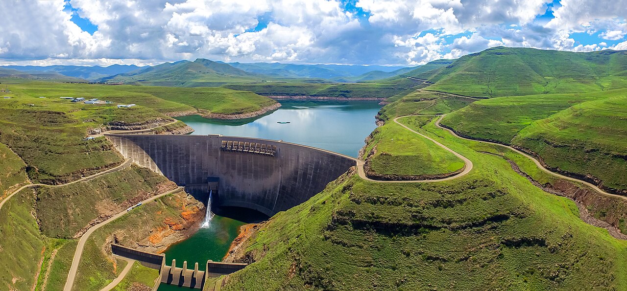
**Katse Dam** in the Maluti Mountains of central Lesotho is a **185-meter** double-curvature arch dam on the Malibamatso River, the second-tallest dam in Africa after Ethiopia's Gibe III. Completed in **1996**, it is the flagship structure of the **Lesotho Highlands Water Project (LHWP)**, one of the most ambitious water transfer schemes in the world, delivering water from Lesotho's mountain rivers through a network of tunnels to the Vaal River system in South Africa.
Introduction
Lesotho, a small mountainous kingdom entirely surrounded by South Africa, has an abundance of water relative to its size, while South Africa's economic heartland in Gauteng Province (home to Johannesburg and Pretoria) is chronically water-scarce. The LHWP exploits this geographic asymmetry through a system of dams and tunnels that move water across the continental divide, providing Lesotho with royalty payments that constitute a significant portion of the national budget.
Engineering & Structure
- Type: Double-curvature arch dam
- Height: 185 meters
- Crest Length: 710 meters
- Reservoir Capacity: 1.95 km³
Katse Dam's arch design is impressively slender, curving across the narrow Malibamatso valley in the heart of the Maluti Mountains at approximately 2,000 meters above sea level. The dam was one of the highest-altitude major dams constructed in Africa, and building in the remote, mountainous terrain required constructing access roads through some of the most challenging landscapes on the continent.
A 45-kilometer transfer tunnel, bored through the mountains at up to 1,000 meters below the surface, connects Katse Reservoir to the Muela hydropower station, where the water generates 72 MW of electricity as it descends before continuing northward through the delivery tunnel system into South Africa's Ash River and ultimately the Vaal Dam.
Geographic Setting
- River: Malibamatso River (Orange/Senqu tributary)
- Location: Thaba-Tseka District, Lesotho
- Coordinates: 29.35°S, 28.85°E
- Elevation: ~2,000 m above sea level
Lesotho is one of the most elevated countries on Earth, with its entire territory above 1,400 meters. The Maluti Mountains form the western escarpment of the Drakensberg range, and the Malibamatso River originates in these highlands before flowing into the Senqu (Orange) River, which eventually reaches the Atlantic Ocean. The dam site is surrounded by dramatic basalt peaks, alpine grasslands, and deep valleys.
The mountain terrain receives significant precipitation — 700 to 1,000 millimeters annually, mostly as summer rain and winter snow — making Lesotho one of the wettest countries in southern Africa relative to its size. This water, which would naturally flow westward to the Atlantic via the Orange River, is instead captured and redirected northward to the Vaal system through the transfer tunnels.
Hydroelectric Power
- Muela Station: 72 MW (using transfer tunnel water)
- Purpose: Water transfer to South Africa (power is secondary)
- Royalties: Significant portion of Lesotho's national budget
While Katse Dam itself does not have a powerhouse, the water transferred through the delivery tunnel drops 500 meters in elevation at the Muela hydropower station, generating 72 MW of electricity for Lesotho's domestic grid. This power supply is critical for a country that previously imported nearly all its electricity from South Africa.
The primary purpose of the entire system is water transfer, not power generation. South Africa pays Lesotho royalties for the water delivered to the Vaal system, and these payments constitute approximately 5-7 percent of Lesotho's GDP — a substantial source of revenue for one of Africa's smallest and poorest nations. The project effectively sells Lesotho's most abundant natural resource to its much larger neighbor.
Environmental & Social Impact
- People Displaced: ~20,000 across LHWP Phase I
- Alpine Ecology: Mountain grasslands and wetlands affected
- Corruption: World Bank-investigated bribery scandal
The LHWP Phase I displaced approximately 20,000 people from the Katse and Mohale reservoir areas, most of them subsistence farmers and herders in remote mountain communities. Compensation included replacement grazing land and cash payments, but the mountainous terrain limited available resettlement options, and many affected families experienced reduced living standards.
The Lesotho Highlands Water Project was also at the center of a landmark corruption scandal. In 2002, Lesotho's High Court convicted Masupha Sole, the former chief executive of the Lesotho Highlands Development Authority, of accepting $2 million in bribes from multinational construction firms competing for contracts. Several European firms were subsequently fined and barred from World Bank projects, making it one of the first successful international anti-corruption prosecutions in the dam-building industry.
Key Facts
- Katse Dam is 185 meters tall, one of the highest arch dams in Africa.
- It transfers water from Lesotho to South Africa's water-scarce Gauteng Province.
- Water royalties from the project constitute 5-7% of Lesotho's GDP.
- The 45 km transfer tunnel runs up to 1,000 meters below the mountain surface.
- The dam sits at approximately 2,000 meters elevation in the Maluti Mountains.
Fun Facts
- Katse Dam is so remote that construction workers had to build 100 kilometers of mountain roads just to reach the site.
- The project's anti-corruption prosecution was a landmark case that led to new international standards for procurement transparency in large infrastructure projects.
- Lesotho's mountains receive enough snow to support Africa's only ski resort, at Afriski near the dam catchment area.
Final Thoughts
Katse Dam is a remarkable example of how geography can be turned into economic opportunity. Lesotho's elevation and rainfall abundance, combined with South Africa's thirst for water, created the conditions for one of the world's most innovative water transfer schemes — one that continues to evolve with Phase II of the Lesotho Highlands Water Project now under construction.
Test Your Knowledge!
Think you know the world's great dams and reservoirs? Try our geography quiz games!
Play Geography Games →