
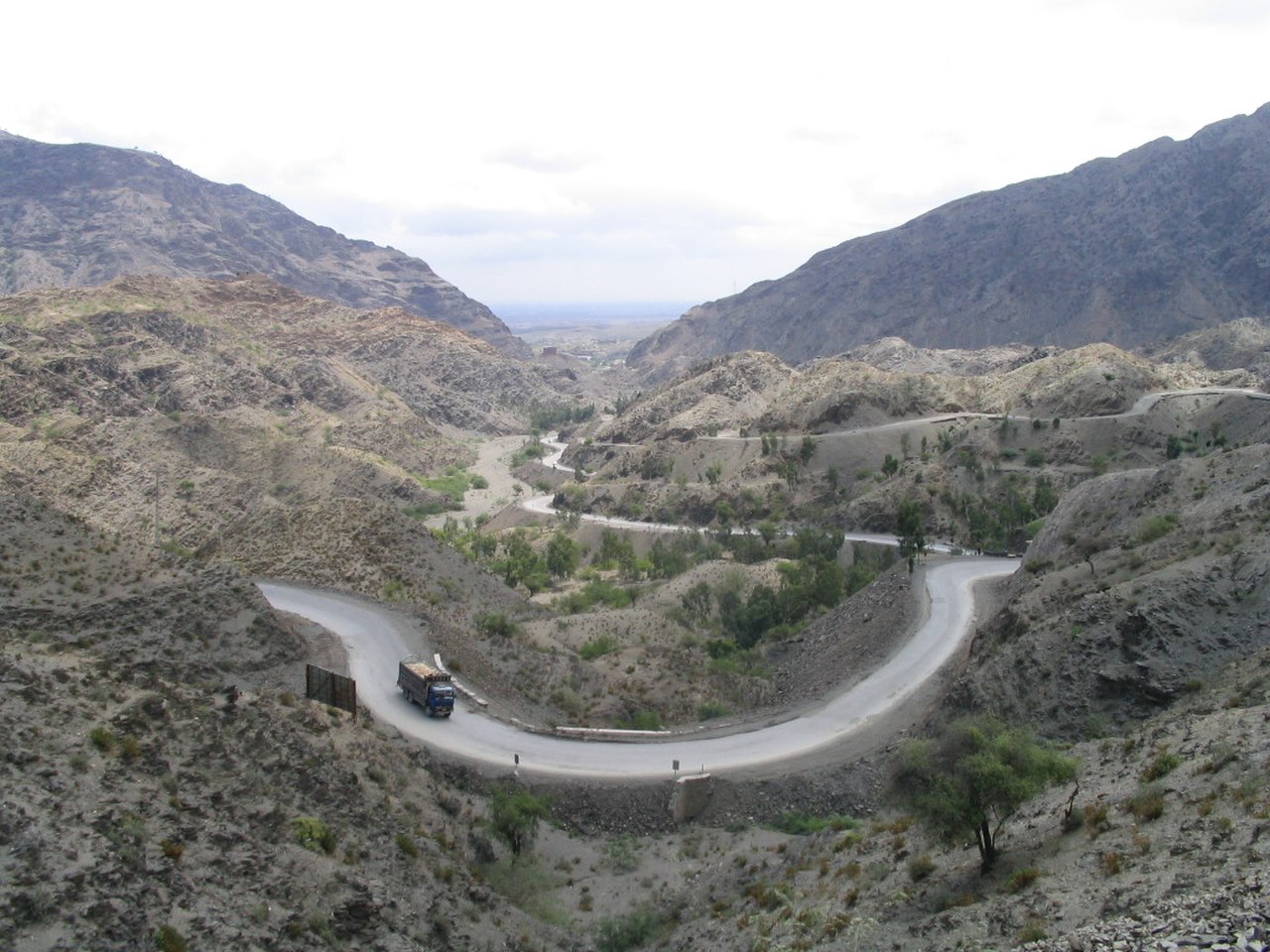
The Khyber Pass is a 53-kilometer-long mountain pass through the Spin Ghar (Safed Koh) range, connecting Peshawar in northern Pakistan to Jalalabad in eastern Afghanistan. Reaching a maximum elevation of about 1,070 meters at Landi Kotal, it has been the most important overland crossing between Central Asia and the Indian subcontinent for at least 2,500 years.
Introduction
Few geographic features in human history have witnessed as much consequential movement as the Khyber Pass. Persian armies under Darius and Cyrus, the Macedonian forces of Alexander the Great in 327 BCE, the Bactrian Greeks, the Kushans, the Mughals founded by Babur in 1526, the British during three Anglo-Afghan Wars, the Soviets in 1979, NATO supply convoys for the post-2001 Afghan War — all crossed the Khyber. The pass is the single defining geographic reason for the close historical and cultural connection between Afghanistan and the Indus Valley, and the political reason that the Pashtun people inhabit both sides of what is now an international border.

Geography & Path
- Length: Approximately 53 km
- Maximum elevation: 1,070 m at Landi Kotal
- Connects: Peshawar (Pakistan) to Jalalabad (Afghanistan)
- Range: Spin Ghar (Safed Koh) Mountains
- Width: 3 m at narrowest, 137 m at widest
The Khyber Pass cuts through limestone and shale ridges that form the eastern end of the Spin Ghar range, the snow-capped western prong of the Hindu Kush system. At Jamrud, where the pass begins, the Khyber rises gradually from the Peshawar Plain at 480 m. It climbs through narrow defiles past Ali Masjid, opens at Landi Kotal (the highest point of the route at about 1,070 m), and descends into Afghanistan through the Loya Shilman Valley toward Tor Kham at the modern border. Beyond Tor Kham, the pass continues down to Jalalabad on the Kabul River at 575 m.
What makes the Khyber strategically distinctive is not its altitude — at 1,070 m it is one of the lower passes through the Hindu Kush — but its accessibility. While most Hindu Kush passes (the Salang, Shibar, Gomal) require crossing 3,000+ m terrain, the Khyber offers a route that wheeled vehicles, pack animals, and modern military vehicles can negotiate year-round. The pass is rarely closed by snow, unlike higher Afghan crossings.
Historical Crossings
- Aryan migrations: ~1500 BCE (debated)
- Persian armies: 6th century BCE under Darius
- Alexander the Great: 327 BCE
- Mahmud of Ghazni: 17 raids into India 1001–1027 CE
- Babur: Founding the Mughal Empire, 1526
- British: Three Anglo-Afghan Wars (1839–42, 1878–80, 1919)
- Soviets: Invasion of Afghanistan, 1979
- NATO supply convoys: 2001–2021
Few geographic features have hosted more invasion armies than the Khyber. Most successful conquests of the Indian subcontinent from the west have come through this pass, beginning with the disputed Aryan migrations of around 1500 BCE and continuing through Mughal, Persian, and British invasions. Conversely, attempted invasions of Afghanistan from the south have repeatedly come to grief in the same pass — most famously in January 1842, when the entire 16,000-person British and Indian retreating column from Kabul was annihilated in the passes east of Jalalabad. Only one British survivor, Dr. William Brydon, reached Jalalabad alive.
The Modern Pass: Roads, Railways, and Drug Routes
- Khyber Pass Road: Modern paved highway following the historical route
- Khyber Pass Railway: 1925 narrow-gauge railway, 34 tunnels, 92 bridges
- Tor Kham crossing: Major Pakistan-Afghanistan border post
- Heroin trafficking: Major route for Afghan opiates to Pakistani and global markets
The Khyber Pass Railway, completed by the British in 1925 to provide rapid military reinforcement to the frontier, climbs from Peshawar to Landi Kotal through 34 tunnels and 92 bridges and culverts — a remarkable engineering achievement that Lord Curzon called "the most stupendous railway between Cairo and Calcutta." The railway is no longer in regular service but the modern N-5 highway remains the main road link between Pakistan and Afghanistan, and during the 2001–2021 NATO mission in Afghanistan, the bulk of allied supplies — perhaps 60–80% by some estimates — passed through Tor Kham via this route.
Geopolitical Significance
- Durand Line: 2,640 km Pakistan-Afghanistan border established in 1893; passes through Khyber territory
- Pashtunistan question: Pashtun population straddles both sides of the border
- Federally Administered Tribal Areas: Pakistani territory through which the Khyber passes (FATA, merged with Khyber Pakhtunkhwa province in 2018)
The Khyber sits at the heart of one of the world's most complex modern geopolitical frontiers. The Durand Line, drawn by British negotiator Sir Mortimer Durand in 1893, passes through the Khyber region but was never accepted by Afghanistan as the legitimate international border. Pashtuns — about 50 million people — straddle this line, with their cultural homeland split between modern Pakistan (where they are about 15% of the population) and Afghanistan (where they are roughly 42% and the dominant political ethnicity). The Khyber Pass is therefore not just a physical route but a contested cultural and political boundary.
Key Facts
- The Khyber Pass is approximately 53 km long with a maximum elevation of about 1,070 m at Landi Kotal
- It has been used as the main land route between Central Asia and India for at least 2,500 years
- Alexander the Great, Babur, the Mughals, and three British armies all crossed it
- The 1925 Khyber Pass Railway included 34 tunnels and 92 bridges in just 41 km
- The 1842 British retreat from Kabul lost 16,000 people in the passes near the Khyber, with only one British survivor reaching Jalalabad
Frequently Asked Questions
Where is the Khyber Pass?
The Khyber Pass is in the Spin Ghar (Safed Koh) Mountains on the border between Pakistan and Afghanistan. It runs for about 53 km from Jamrud near Peshawar in Pakistan's Khyber Pakhtunkhwa province to Tor Kham at the Afghan border, then continues another 50 km down to Jalalabad in eastern Afghanistan.
Why is the Khyber Pass historically important?
The Khyber has been the principal land route between Central Asia and the Indian subcontinent for at least 2,500 years. Persian, Greek, Bactrian, Kushan, Ghaznavid, Mughal, British, and Soviet armies have all used it; some, like Babur's Mughal forces in 1526, founded entire empires after crossing it. Its accessibility (only 1,070 m elevation) made it the practical route while higher Hindu Kush passes were impassable.
Who controls the Khyber Pass today?
The Pakistani side of the Khyber Pass is administered by the government of Khyber Pakhtunkhwa province (the former Federally Administered Tribal Areas were merged with the province in 2018). The Afghan side is in Nangarhar Province under the current Taliban government. The Tor Kham checkpoint is the main international border crossing.
Is the Khyber Pass safe to visit?
The Khyber Pass region has been a security concern for decades and visitor access depends on the security situation. The Pakistani government typically requires special permits for foreign visitors and tourism is limited. The Afghan side has been particularly volatile since 2001. Road convoys still move daily through the pass, but independent travel is not generally recommended.
What is the Khyber Pass Railway?
The Khyber Pass Railway was a 41-km narrow-gauge railway built by the British between 1920 and 1925 to provide military reinforcement to the Afghan frontier. It included 34 tunnels and 92 bridges in just 41 kilometers of track. The line is no longer in regular service, though restoration projects have run heritage trains in recent years.
Final Thoughts
The Khyber Pass is not just a geographic feature — it is one of the most consequential single locations in human history. The pass has shaped the languages, religions, ethnic distribution, and political geography of all of South Asia. Twenty-five centuries of armies, traders, and migrants have crossed it, and modern South Asia is in many ways their cumulative product.
Test Your Geography Knowledge!
Think you know the world's mountains, passes, and borderlands? Try our games.
Play Geography Games →