
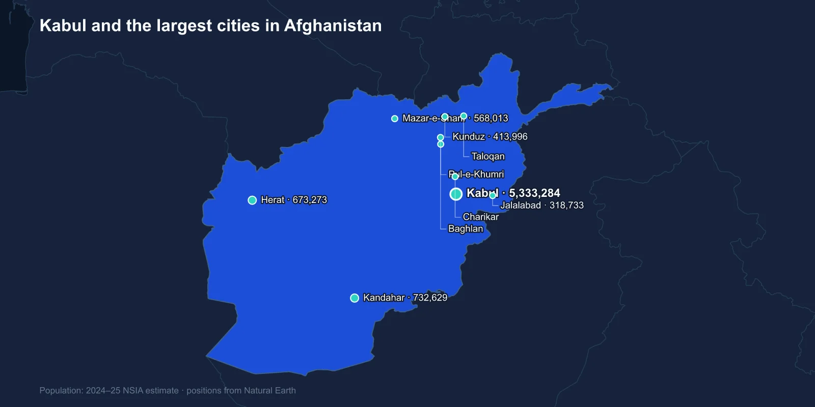
The largest cities in Afghanistan are Kabul (about 5,333,284), Kandahar (732,629), Herat (673,273), Mazar-e-Sharif (568,013), Kunduz (413,996), Jalalabad (318,733), Taloqan (284,990), Pul-e-Khumri (230,112), Charikar (222,751) and Baghlan (219,073). These are estimates from the National Statistics and Information Authority; Afghanistan's only complete census was taken in 1979.
Kabul is more than seven times the size of Kandahar, and the four largest cities between them hold a substantial share of all Afghan urban residents. The rest of the list is a set of provincial centres, almost all of them strung along one road.
The Ring Road Is the Urban System
Afghanistan's settlement pattern is dictated by the Hindu Kush, which runs diagonally across the country and splits it into basins that are difficult to cross. The response, built in stages from the 1960s with competing American and Soviet money, was Highway 1 — a circular route of roughly 2,200 kilometres linking Kabul, Kandahar, Herat and Mazar-e-Sharif and running around the mountains rather than through them.
Nearly every city on this list sits on that ring or on a spur from it. Jalalabad is on the road east to Peshawar, Kunduz and Pul-e-Khumri on the road north to the Uzbek border, Charikar just north of Kabul where the highway begins the climb to the Salang Pass.
The Salang Tunnel, opened by Soviet engineers in 1964 at about 3,400 metres, is the only reliable direct link between Kabul and the north. Close it and the northern cities are effectively a separate country, which is precisely what happened during several winters of the civil war.
Kabul Grew Faster Than Almost Anywhere
Kabul sits in a bowl at about 1,790 metres, ringed by mountains, on a site that has been a settlement for well over three thousand years. It was a Mughal favourite — Babur chose to be buried there, in gardens that still carry his name — and it became the Afghan capital in 1776.
Its modern growth is extraordinary. The city held somewhere around 500,000 people in 1979. It was then fought over and partly destroyed during the civil war of the 1990s, particularly in the western districts, before expanding after 2001 to more than five million.
That growth was driven by returning refugees, by rural displacement and by the international presence, and it far outran the infrastructure. Whole districts were built informally on the steep slopes of the surrounding hills — houses climbing gradients no vehicle can reach, carrying water up by hand — and those hillside settlements are now among the most visually distinctive parts of the city.
Kandahar and the Origins of the State
Kandahar in the south is the Pashtun heartland and, in a real sense, where the Afghan state began. Ahmad Shah Durrani was crowned there in 1747, and his mausoleum stands in the city centre next to the shrine that holds the Cloak of the Prophet.
That relic matters politically. In 1996, Mullah Omar displayed the cloak in Kandahar before a crowd and was proclaimed Amir al-Mu'minin, the act that established the Taliban's claim to legitimate authority. Kandahar was the movement's capital through its first period in power and remains its spiritual centre.
The city sits in an irrigated basin on the Arghandab river, historically famous for pomegranates and grapes, and the fertile districts around it were among the most heavily contested ground in the war after 2001.
Herat Looks West
Herat, in the far west near the Iranian border, has always been oriented towards Persia rather than the Indian subcontinent. It was the capital of the Timurid renaissance in the fifteenth century under Shah Rukh and Queen Gawhar Shad, and the centre of a school of miniature painting associated with Bihzad that shaped Persian and Mughal art for centuries.
The minarets of Gawhar Shad's musalla complex still stand in the open ground north of the city, leaning at alarming angles — what remains after British engineers demolished much of the complex in 1885 to clear fields of fire against an expected Russian advance that never came.
Herat is Afghanistan's most prosperous provincial city, largely because of trade with Iran and because its customs revenue is substantial. Persian, in its Afghan form Dari, is the dominant language, and the cultural distance from Kandahar is considerable.
Mazar-e-Sharif and the Blue Shrine
Mazar-e-Sharif means the noble shrine, and the city is named for the mosque at its centre — a blue-tiled complex that many Afghans believe holds the tomb of Ali, the same figure buried at Najaf in Iraq. Both claims cannot be true, but the Mazar shrine is the focus of the Nowruz celebrations each March, when a great banner is raised in the courtyard.
The city is the commercial hub of the north, close to the Uzbek border at Hairatan and to the Amu Darya. Its population is largely Tajik, Uzbek and Hazara rather than Pashtun, and it was the base of the northern factions through the 1990s.
Nearby Balkh, now a small town, was one of the great cities of the ancient world — Bactra, the mother of cities — and the birthplace attributed to Rumi.
The Northern Towns and the Cotton Belt
Kunduz, Taloqan, Pul-e-Khumri and Baghlan form a cluster across the northern plains. The region was developed for irrigated cotton from the 1930s, and Kunduz in particular grew around the Spinzar cotton company, which was for decades one of the largest industrial employers in the country.
Pul-e-Khumri has a hydroelectric plant and a cement works, and it sits at the junction where the road from the Salang Tunnel meets the routes west and east. Its name means bridge over the Khumri, and the crossing is the reason the town exists.
All four changed hands repeatedly after 2015, and Kunduz was briefly taken twice, in 2015 and 2016 — the first provincial capitals to fall to the Taliban before the general collapse of 2021.
Jalalabad and the Road to Pakistan
Jalalabad sits at a much lower altitude than Kabul, in a warm subtropical basin where the Kabul and Kunar rivers meet, and it has long been the winter retreat for people escaping the capital's cold.
It is the last Afghan city on the road to the Khyber Pass and Peshawar, which makes it the country's main overland trade link with Pakistan and a transit point for goods moving in both directions. Citrus and rice grow in the valley around it.
The road between Kabul and Jalalabad descends through a narrow gorge cut by the Kabul river and has a long reputation as one of the most dangerous highways anywhere, a combination of sheer drops, heavy lorry traffic and, for two decades, ambushes. It is also the route by which most of Afghanistan's imported goods reach the capital.
The Cities That Are Not There
Two absences are worth noting. Bamiyan, in the central highlands, is a small town rather than a major city, but it is the Hazara centre and the site of the sandstone Buddhas destroyed by the Taliban in March 2001 — an act that drew international condemnation months before the events that brought foreign forces into the country.
Ghazni, on the southern ring road, appears at the bottom of the top twelve today but was the capital of a much larger empire. Under Mahmud of Ghazni around the year 1000 it controlled territory from Persia into northern India, and its minarets and the tomb of Mahmud survive on the plain outside the modern town.
Both are reminders that Afghan urban importance has shifted repeatedly. The cities that matter now are not the ones that mattered a thousand years ago, and the ruins of the old ones are scattered across the country.
Why the Numbers Are Estimates
Afghanistan has conducted exactly one full census, in 1979, and even that was incomplete — the enumeration was cut short as the war began, and some districts were never covered. Every figure since has been a projection built on that base, adjusted with household surveys and satellite imagery.
Attempts to organise a count have failed for the same reasons they fail elsewhere in the region: population determines political representation among ethnic groups whose relative sizes are themselves disputed, and no government has been confident enough of the answer to ask the question.
The result is unusually wide uncertainty. National population estimates range from roughly 34 to 43 million depending on the source, and city figures inherit that spread. What is not in doubt is the ordering, and the scale of Kabul's lead.
Movement has also been exceptional. Afghanistan produced one of the largest refugee populations in the world for four decades, with millions in Pakistan and Iran, and those flows have reversed and reversed again with each change of government. Mass returns from Pakistan in 2023 and 2024 pushed hundreds of thousands of people back across the border into cities that had not planned for them.
Road Towns and Basin Towns
Afghan cities are road towns and basin towns: a capital in a mountain bowl, a Pashtun southern centre where the state was founded, a Persian-facing western city, a northern shrine city on the plains, and a string of provincial capitals along a single ring.
The Hindu Kush is the reason the ring road exists at all, and our Afghanistan country guide covers that terrain and the borders around it. Kabul has its own profile, and the shrines at Mazar and Kandahar are placed in context by Afghan religious life.
