
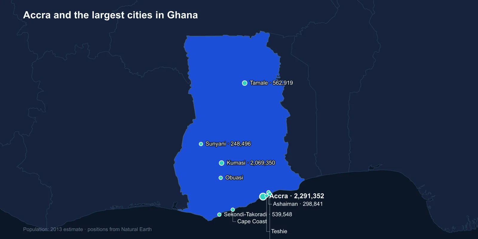
The largest cities in Ghana are Accra (about 2,291,352), Kumasi (2,069,350), Tamale (562,919), Sekondi-Takoradi (539,548), Ashaiman (298,841), Sunyani (248,496), Cape Coast (227,269), Obuasi (180,334), Teshie (176,597) and Tema (161,612). These are 2013 estimates; Ghana's 2021 census recorded a national population of 30.8 million and substantially larger metropolitan areas.
The notable feature is at the top. Accra leads Kumasi by only about ten per cent, which makes Ghana one of the few countries in the region without a runaway primate city. That near-parity is the product of two quite different histories.
Kumasi Was a Capital First
Kumasi was founded in the 1680s as the capital of the Asante Empire, which at its height controlled most of what is now southern Ghana and beyond. It was a planned royal city with a palace, a mausoleum complex at Bantama, and a road network radiating to the provinces — a genuine pre-colonial urban centre rather than a trading post.
The British burned it in 1874 and again in 1896, and in 1900 the governor's demand to sit on the Golden Stool — the sacred object embodying the soul of the Asante nation, which no person may sit upon — provoked the War of the Golden Stool, led by Yaa Asantewaa, the queen mother of Ejisu.
The Asantehene still reigns from the Manhyia Palace, and the Asante kingdom retains real cultural and considerable informal political authority. Kumasi's size reflects a centre that existed long before the colony and never stopped being important.
Accra Grew Around Three Forts
Accra's origins are the opposite: it is a coastal trading settlement that became a capital because of European commerce. The Ga people's towns on that shore acquired three European forts within a few kilometres of each other — Danish Christiansborg, Dutch Crevecoeur and English James Fort — each serving a different trading nation.
The British moved the colonial capital there from Cape Coast in 1877, largely on health and harbour grounds, and Christiansborg Castle became the seat of government, remaining so through independence until the presidency moved to the new Jubilee House.
Greater Accra has since spread far beyond the old town. The 2021 census put the region above five million, and the built-up area now runs continuously east to Tema and west along the coast, absorbing what were separate towns.
Ashaiman, Teshie, Tema: One City on the List Three Times
Three entries in the top ten are part of Greater Accra. Teshie is an old Ga coastal town now enveloped by the capital's eastern spread. Tema is the planned port city built from 1952 under Kwame Nkrumah, with a deep-water harbour, an industrial zone and a grid of numbered residential communities.
Ashaiman grew up immediately beside Tema as the unplanned settlement housing the labour that built and ran it — a dense, largely informal town that was never part of the plan and is now one of the largest urban areas in the country.
The pairing is a textbook case. A modernist port city laid out on paper for a designed population, and the much larger unplanned town that assembled itself next door to supply it with workers.
The Coast the Forts Are On
Cape Coast, seventh, was the colonial capital before Accra and sits among the densest concentration of European fortifications anywhere outside Europe — somewhere around thirty forts and castles along roughly 500 kilometres of shoreline, built by the Portuguese, Dutch, Danes, Swedes, Brandenburgers and British.
Cape Coast Castle and Elmina Castle are UNESCO World Heritage Sites and were principal points of embarkation in the Atlantic slave trade. Elmina, built by the Portuguese in 1482, is the oldest European building still standing south of the Sahara.
Both are now central to Ghana's diaspora tourism, formalised by the Year of Return in 2019 marking four centuries since the first recorded landing of enslaved Africans in Virginia. Cape Coast also holds a disproportionate share of the country's oldest secondary schools, and a long tradition of supplying the professional class.
Takoradi, Oil and the Western Line
Sekondi-Takoradi is a twin city on the western coast and was Ghana's first deep-water port, opened in 1928 as the outlet for the cocoa, timber and manganese of the western forests, connected inland by the Western Line railway.
Its recent growth comes from offshore oil. The Jubilee field, discovered in 2007 about sixty kilometres out, made Ghana a producer from 2010, and Takoradi became the onshore base for the industry — with the property inflation and service-sector boom that follows in such places.
Gold Under Obuasi
Obuasi exists because of one of the richest gold deposits in the world. Mining there predates the colony — Asante gold was traded north across the Sahara for centuries — and industrial extraction has been continuous since the 1890s under what became Ashanti Goldfields and later AngloGold Ashanti.
The mine has gone through closure, care and maintenance, and redevelopment, and the town's fortunes have followed it exactly. It is the clearest single-industry town on the list, and the reason the whole colony was called the Gold Coast.
Ghana overtook South Africa as Africa's largest gold producer in 2019, though a growing share of that output now comes from small-scale operations rather than the deep mines. The informal sector known as galamsey employs very large numbers of people and has become the country's most contentious environmental issue, silting rivers and stripping forest across the western regions.
Tamale and the North
Tamale is the third-largest city and the only one of the top ten in the north. It sits in savanna rather than forest, it is predominantly Muslim and Dagomba where the south is predominantly Christian and Akan, and it has a very different economic base — shea, cattle, grain and cotton rather than cocoa and gold.
The north-south divide is the structural fact of Ghanaian development. Colonial investment concentrated on the cocoa forests and the coastal ports; the northern territories were administered as a labour reserve, and poverty rates there remain markedly higher.
Tamale has nonetheless been one of the fastest-growing cities in West Africa, and it is now the service and education centre for the whole northern half of the country. Sunyani, sixth, sits in the transitional zone between the two, a cocoa and forestry administrative town.
Tamale is also a bicycle city, unusual in the region — the flat savanna terrain and the distances involved made two wheels the default long before motorcycles became affordable, and the morning traffic on its main roads looks unlike anywhere else in Ghana.
Cocoa, and the Farms That Are Not in the Cities
Ghana is the world's second-largest cocoa producer after neighbouring Ivory Coast, and the crop underwrites much of the economy that these cities service. It arrived late and by an individual act: Tetteh Quarshie, a blacksmith, is credited with bringing pods back from Fernando Po in 1876 and planting them at Mampong.
Within four decades the Gold Coast was the largest producer in the world. The farms are smallholdings in the forest belt around Kumasi and Sunyani rather than plantations, and the buying, weighing and haulage they generate is a substantial part of what those towns do.
It also explains the shape of the railway network. Both the Eastern and Western lines were built to bring cocoa and minerals down to the coast, and neither was ever extended north — which is a large part of why Tamale developed so much later than the forest towns.
The Lake That Displaced 80,000 People
The Akosombo Dam, completed in 1965, created Lake Volta, which by surface area is the largest reservoir in the world and covers about 3.6 per cent of Ghana's entire territory.
It was built to power an aluminium smelter at Tema, the industrial anchor of Nkrumah's development plan, and it flooded a substantial stretch of the Volta basin. Around 80,000 people in more than 700 villages were resettled, and the fishing communities that grew up along the new shoreline have since become the focus of long-running concerns about child labour on the lake.
What Changed at the 2021 Census
Ghana's 2021 census was the first conducted digitally, using tablets rather than paper, and it produced figures substantially higher than the projections in wide use. The national total came in at 30.8 million, and Greater Accra overtook Ashanti as the most populous region for the first time.
The city-level picture also shifted: municipal boundaries were redrawn repeatedly in the intervening years as districts were split and upgraded, which makes direct comparison between the 2013 estimates here and the 2021 results difficult. What is not in doubt is that both Accra and Kumasi are now well above two million and that the gap between them remains narrow.
Three Economies Stacked on Each Other
Ghana's cities record three economies stacked on each other: an Asante capital in the forest, a string of European forts along the coast that became ports and then a national capital, a gold town, an oil town, and a savanna city that the colonial economy largely bypassed.
The divide running between Tamale and the forest cities is largely the one described in Ghanaian religious life. The Accra profile covers the capital and its forts, and the Volta basin behind them appears in our Ghana country guide.
