
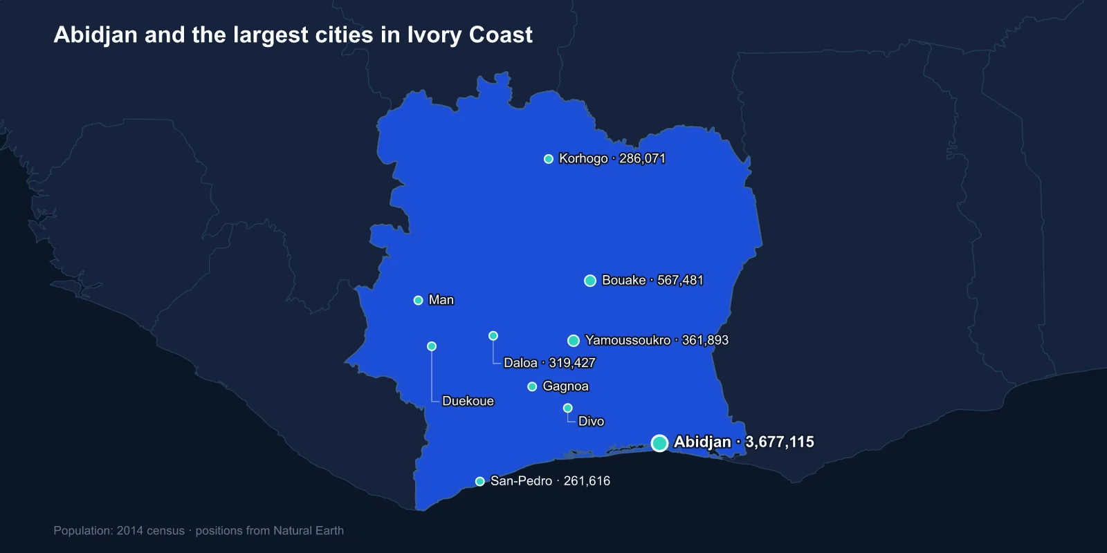
The largest cities in Ivory Coast are Abidjan (3,677,115), Bouake (567,481), Yamoussoukro (361,893), Daloa (319,427), Korhogo (286,071), San-Pedro (261,616), Gagnoa (213,918), Man (188,704), Duekoue (185,344) and Divo (184,481). These are 2014 census figures; the 2021 census put Abidjan's autonomous district above six million.
The ranking's oddity is in third place. Yamoussoukro is the official capital of Ivory Coast, and it is roughly a tenth the size of Abidjan, which holds every embassy, every ministry that matters in practice and the entire economy.
A Capital Moved to a President's Birthplace
In 1983 Felix Houphouet-Boigny, who had led the country since independence in 1960, declared that the capital would move to Yamoussoukro. It was his home village, a settlement of a few thousand people named after his great-aunt, Queen Yamousso.
What followed was a construction programme on a scale entirely out of proportion to the place: six-lane boulevards lit end to end, a presidential palace with a crocodile lake, a polytechnic institute, a foundation for peace, and an international airport with a runway long enough for Concorde.
The centrepiece is the Basilica of Our Lady of Peace, consecrated by John Paul II in 1990 and recognised by Guinness World Records as the largest church in the world by area, larger than St Peter's in Rome, which it deliberately echoes. It seats 18,000 and stands in a country where Christians are a minority of the population, in a town of a few hundred thousand.
The move was never completed. The National Assembly sits in Yamoussoukro and the Senate was established there, but the presidency, the ministries and the diplomatic corps have remained in Abidjan for four decades.
Abidjan Is Built Around a Lagoon
Abidjan sits on the Ebrie lagoon, a long shallow body of water separated from the Atlantic by a sandbar, and the city is spread across peninsulas and islands linked by bridges. The Plateau, the central business district, holds a skyline of 1970s towers that earned the city the nickname of the Manhattan of the tropics.
Its growth was unlocked by an engineering project. The Vridi Canal, cut through the sandbar and opened in 1951, gave the lagoon a deep-water connection to the ocean and turned Abidjan into the principal port of francophone West Africa almost overnight. Before that the coast had no usable harbour at all.
The port handles not only Ivorian trade but a large share of the imports and exports of Burkina Faso, Mali and Niger, which gives the city a regional weight beyond its own country.
The Miracle, and What Paid for It
Between 1960 and 1980 Ivory Coast recorded growth rates that were described at the time as the Ivorian miracle, and Abidjan was where it was visible. The basis was agricultural: the country became the world's largest producer of cocoa, a position it still holds by a wide margin, supplying something in the order of forty per cent of global output.
Coffee, palm oil and timber added to it. The plantation economy drew enormous labour migration from Burkina Faso and Mali into the forest zone of the south and west, and that migration is the origin of the political crisis that followed.
When cocoa prices fell in the 1980s and the founding president died in 1993, the question of who counted as Ivorian — ivoirite — became the central fault line in national politics, aimed squarely at the northern and immigrant populations who had worked the plantations.
Bouake and a Country Cut in Half
Bouake, the second city, sits in the centre of the country and was the headquarters of the rebellion that began in September 2002 and split Ivory Coast in two for nearly a decade.
The Forces Nouvelles held the north from Bouake; the government held the south from Abidjan; a buffer zone patrolled by French and UN troops ran between them. The division lasted until the post-election crisis of 2010 and 2011, which ended with several thousand dead and Laurent Gbagbo removed by force.
Bouake's population fell sharply during the partition as people left, and it has since recovered. The city is a textile and transport centre at the junction of the road and rail routes north, and its market is one of the largest in the interior.
The North, and the Other Ivory Coast
Korhogo, fifth, is the principal city of the north — Senufo country, savanna rather than forest, predominantly Muslim, with an economy based on cotton, cattle and shea rather than cocoa.
It is known for a distinctive painted cloth, made by applying fermented mud to hand-woven strips, and for a long tradition of Senufo sculpture. The north-south divide in Ivory Coast is agricultural, religious and linguistic at once, and it maps directly onto the wartime partition.
Ferkessedougou further north is the rail junction on the line to Burkina Faso, and the corridor through it is the reason Abidjan's port matters to three landlocked countries.
San-Pedro and the Second Port
San-Pedro, sixth, was built from nothing in the late 1960s as a deep-water port for the south-west, and it is now the world's largest cocoa-exporting port by volume. The region behind it was opened up for plantations at the same time, in a planned colonisation of the last stretch of dense forest in the country.
The environmental cost has been severe. Ivory Coast has lost the overwhelming majority of its original rainforest since independence — one of the steepest rates of deforestation recorded anywhere — and cocoa expansion is the principal cause, including inside supposedly protected areas.
San-Pedro is also the shipping point for the iron ore and manganese projects of the south-west and for timber from the last commercially worked forests. Its hinterland was settled largely by migrants from the centre and north within living memory, which is why land tenure there is contested in ways it is not in older parts of the country.
Ivory Coast has since become one of the first countries to face EU deforestation-free import rules, which require cocoa to be traced to a plot that was not forest after 2020. Compliance falls on smallholders around exactly these towns, and on the cooperatives in Daloa and Gagnoa that buy from them.
The Western Cities and the Forest Frontier
Daloa, Gagnoa, Duekoue and Divo all lie in the forest belt of the centre-west and south-west, and all grew on cocoa and coffee. They are the frontier towns of the plantation economy, and they were the most violent places in the country during the crises of the 2000s.
Duekoue in particular saw a massacre in March 2011 in which several hundred people were killed, a consequence of land disputes between indigenous Guere communities and migrant planters that had been building for decades.
Man, in the far west, sits among forested mountains near the Guinean and Liberian borders and is the centre of Dan country, known for mask traditions and for the stilt dancers that perform them.
The region around Man took in very large numbers of refugees during the Liberian civil wars, and the fighters and weapons that crossed in the other direction shaped the Ivorian conflict when it came. Borders in this corner of West Africa have been porous to armed movements for thirty years.
The Bridge, the Railway and the Corridor North
Abidjan's lagoon setting creates a permanent transport problem: the city is divided by water, and everything depends on a small number of bridges. For decades there were only two crossings between the northern districts and the Plateau, and the congestion on them was legendary.
The Henri Konan Bedie bridge, opened in 2014, was the first new crossing in more than forty years. A further bridge and an urban metro line financed by France have followed, the latter intended to carry hundreds of thousands of passengers a day along the north-south axis.
The older Abidjan-Ouagadougou railway runs from the port through Bouake and Ferkessedougou to Burkina Faso, and it is the artery that makes the city a regional hub rather than a national one. When the country partitioned in 2002 the line was cut, and the landlocked economies to the north felt the effect within weeks.
Two Names, and Which to Use
The country asked in 1986 that it be called Cote d'Ivoire in every language, rather than translated. The request has been honoured inconsistently: the United Nations uses Cote d'Ivoire, most English-language usage still says Ivory Coast, and both appear in official Ivorian material in English.
The underlying name comes from the same Atlantic trade that produced the Gold Coast and the Slave Coast, dividing the shoreline by commodity. Of the three names, this is the only one still attached to a country.
Everything Points at One Port
Ivory Coast's cities describe a plantation economy pointed at a single port: a lagoon city that a canal turned into the hub of francophone West Africa, a purpose-built capital in a village that never took, a central city that became a rebel headquarters, and a line of forest towns where the cocoa actually grows.
The north–south divide that split the country in two is the one described in Ivorian religious life. The capital that never took is examined in the Yamoussoukro profile, and the forest and savanna belts these cities sit in are covered by our Ivory Coast country guide.
