
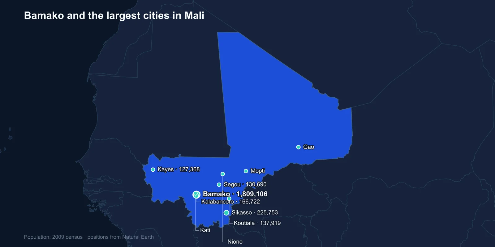
The largest cities in Mali are Bamako (1,809,106), Sikasso (225,753), Kalabancoro (166,722), Koutiala (137,919), Segou (130,690), Kayes (127,368), Kati (114,983), Mopti (114,296), Niono (91,554) and Gao (86,633). These are 2009 census figures; Bamako is now generally estimated well above three million.
The city most people associate with Mali is not in the top ten. Timbuktu holds somewhere around 30,000 people, which places it far down the national list — a reversal that took about four hundred years.
Bamako Grew From Almost Nothing
Bamako was a village of a few thousand when the French established a post there in 1883. It became the capital of French Sudan in 1908, largely because it sat at a navigable point on the Niger and at the end of the railway from Dakar.
Its growth since independence has been among the fastest of any African capital. From roughly 130,000 people in 1960 it has passed three million, expanding across both banks of the Niger and up into the sandstone escarpment that frames the city.
Kalabancoro and Kati, third and seventh on this list, are not independent cities at all — they are contiguous suburbs, Kalabancoro immediately south of the capital and Kati a garrison town just north of it. Their presence in the top ten is a measure of how much of Malian urban growth has been Bamako's growth.
Kati is worth noting for another reason: its military camp has been the starting point of more than one Malian coup, including the one in March 2012 that removed the government just as the north was being lost.
Timbuktu Was Never Mainly About Gold
Timbuktu's reputation in Europe was built on gold, and on the pilgrimage of Mansa Musa of Mali in 1324, whose spending in Cairo was reported to have disrupted the Egyptian gold price for years.
The city's real substance was scholarship and trade. It sat where the Niger comes closest to the Sahara, the transfer point between river craft and camel caravans, and it grew into a centre of Islamic learning with the Sankore, Djinguereber and Sidi Yahya mosques and a private manuscript culture that produced hundreds of thousands of texts on law, astronomy, medicine and poetry.
Its decline was commercial. When European ships began carrying West African trade by sea from the sixteenth century, the trans-Saharan routes lost their purpose, and a Moroccan invasion in 1591 removed what remained of the city's autonomy. By the time the first Europeans reached it in the nineteenth century, expecting a golden city, they found a modest desert town and were bitterly disappointed.
The Manuscripts and the Occupation
In 2012 a Tuareg rebellion and then jihadist groups took control of northern Mali, including Timbuktu. Mausoleums of Sufi saints in the city were destroyed as idolatrous, an act for which Ahmad al-Faqi al-Mahdi was later convicted at the International Criminal Court — the first conviction there for the destruction of cultural heritage.
The manuscripts were largely saved. Librarians and families, coordinated in part by Abdel Kader Haidara, moved hundreds of thousands of texts out of the city in trunks and on river boats to Bamako, in an operation conducted quietly over months.
French forces intervened in January 2013 and retook the northern towns. Insecurity across the north and centre has continued nonetheless, and Timbuktu remains difficult to reach.
The Cotton Belt in the South
Sikasso and Koutiala, second and fourth, sit in the far south where rainfall is highest and the land most productive. This is Mali's cotton zone, and it is the economic counterweight to the capital.
Koutiala is often called the cotton capital, and the crop supports several hundred thousand households across the region through the state-linked buying company CMDT. Sikasso, closer to the Ivorian and Burkinabe borders, is a fruit and vegetable centre as well — mangoes from the region are exported to Europe.
The south's productivity and the north's insecurity are the two poles of Malian politics, and the difference in rainfall between them is the underlying reason.
Mali is also Africa's third-largest gold producer, and the mines are in the west and south rather than near any of the famous desert towns. Industrial operations at Sadiola, Loulo and Morila sit closer to Kayes and Sikasso than to Timbuktu, and artisanal digging employs several hundred thousand people across the same belt.
Segou, Niono and an Irrigation Scheme From 1932
Segou, on the Niger upstream of Bamako, was the capital of the Bambara kingdom in the eighteenth and nineteenth centuries and retains a distinctive mud-brick colonial and pre-colonial architecture along the river.
Niono, ninth on the list, exists because of the Office du Niger. Begun by the French in 1932, the scheme diverts water from the Niger at the Markala barrage into a canal network irrigating a large area of the inland delta, originally intended to grow cotton for French mills and now producing a substantial share of Malian rice.
It is one of the oldest and largest irrigation schemes in West Africa, and its land has become the subject of major foreign investment interest — which has in turn raised disputes over the rights of the farmers already working it.
Mopti and the Inland Delta
Mopti sits where the Bani joins the Niger, at the edge of the inland delta — a vast seasonal floodplain that expands to thousands of square kilometres in the wet season and supports fishing, rice and cattle in an interlocking system worked out over centuries between Bozo fishers, Fulani herders and Bambara farmers.
The town is built on causeways between channels and is the main river port of the interior. Nearby Djenne holds the Great Mosque, the largest mud-brick building in the world, replastered each year by the whole town in a communal festival.
Central Mali around Mopti has since 2015 become the most violent part of the country, with conflict between armed groups and between farming and herding communities displacing large numbers of people towards the towns.
Kayes, the Hottest City in Africa
Kayes in the far west is a railway town on the line to Dakar and was the capital of French Sudan before Bamako. It has a reputation as one of the hottest inhabited places in Africa, with summer temperatures regularly above 45C.
The region is also the historic source of most Malian emigration to France, and remittances from the Kayes diaspora fund a visible share of local construction, clinics and mosques.
West of Kayes are the Manding highlands where the empire of Mali began. The Kurukan Fuga charter, an oral constitution attributed to Sundiata Keita's assembly in about 1236 and still recited by griots, is claimed as one of the earliest statements of rights anywhere; UNESCO added it to its intangible heritage list in 2009.
Gao and the Desert Towns
Gao, tenth on the list, sits on the Niger at the eastern end of the river's great bend and was the capital of the Songhai Empire, which succeeded Mali as the dominant power in West Africa in the fifteenth and sixteenth centuries. The Tomb of Askia, a stepped pyramid of mud brick built in 1495, is a UNESCO World Heritage Site.
Like Timbuktu, Gao was taken in 2012 and retaken in 2013, and it has remained a garrison town and a base for international forces since. Kidal, further north in the Adrar des Ifoghas, is smaller still and has been at the centre of Tuareg autonomy claims through every Malian rebellion since 1963.
The Music That Came Out of These Towns
Mali's cultural export is music, and it maps onto this list precisely. The griot tradition of hereditary musicians runs through Bamako and Segou; the desert blues associated with Tinariwen came out of Tuareg communities around Kidal and the refugee camps of the 1990s; Ali Farka Toure played from Niafunke on the river near Timbuktu.
The Festival au Desert, held in the dunes outside Timbuktu from 2001, became the best-known music event in the Sahara before the occupation forced it into exile in 2013. When the jihadist groups banned music across the north, it was understood locally as an attack on the region's principal form of public life.
Why the Census Is From 2009
Mali's last general census was conducted in 2009. A count planned for 2022 was repeatedly delayed by the security situation across the north and centre, the two coups of 2020 and 2021, and the departure of the French and United Nations missions.
Population has grown very fast in the interval — Mali's fertility rate is among the highest in the world — and Bamako in particular has roughly doubled. The list's ordering is probably still sound in the south; in the north, where displacement has been heaviest, it is much less reliable.
From the Desert Edge to the Wet South
Mali's cities record a shift from the desert edge to the wet south: a colonial river post that became one of Africa's fastest-growing capitals, a cotton belt along the southern border, an irrigation scheme that created a town, and a line of Niger river ports whose importance has been falling since Europeans learned to sail around them.
Timbuktu’s reputation rests on the scholarly tradition set out in Malian religious life, not on its size. The Bamako profile covers the capital that overtook it, and the Sahara, Sahel and Niger river are mapped in our Mali country guide.
