
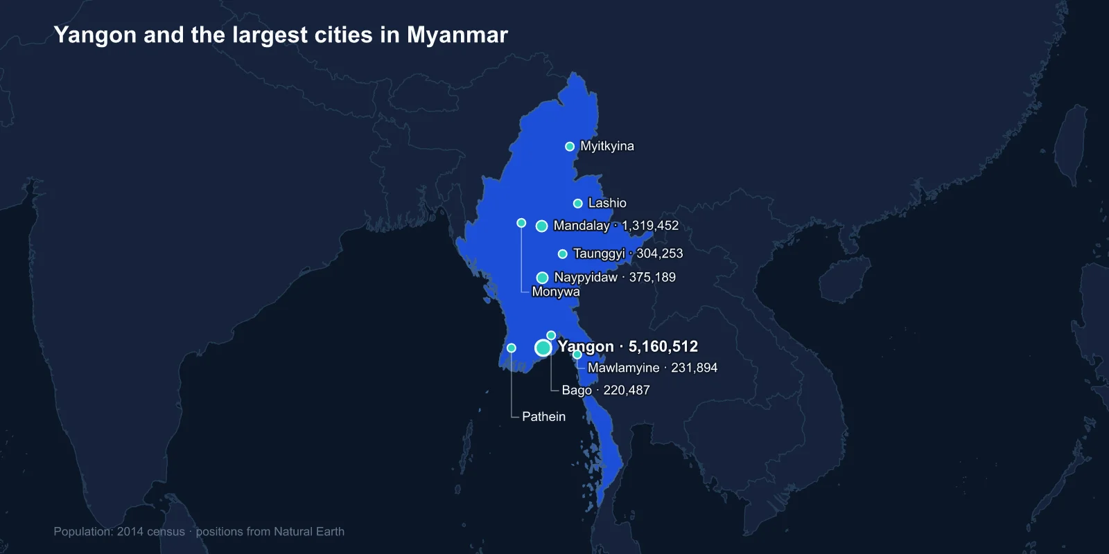
The largest cities in Myanmar are Yangon (5,160,512), Mandalay (1,319,452), Naypyidaw (375,189), Taunggyi (304,253), Mawlamyine (231,894), Bago (220,487), Monywa (201,446), Myitkyina (180,491), Pathein (172,923) and Lashio (144,031). These come from the 2014 census, the first the country had conducted in thirty-one years.
The list has an unusual shape. Yangon is nearly four times Mandalay, Mandalay is more than three times the capital, and the capital did not exist as a city at the previous census.
A Capital Announced After It Was Built
On 6 November 2005, at an hour reportedly chosen by astrologers, convoys of civil servants were ordered to leave Yangon for a site in the dry scrub near Pyinmana, roughly 320 kilometres north. The new capital was named Naypyidaw, usually translated as seat of the king, and its existence was made public only once the move was under way.
What they arrived at was a city built at a scale that has become notorious: boulevards up to twenty lanes wide carrying almost no traffic, ministries spread miles apart, separate residential zones for different grades of official, and a replica of Yangon's Shwedagon Pagoda — the Uppatasanti — built a foot shorter than the original out of deference.
The reasoning has never been officially explained. The most common readings are strategic: a capital in the interior is harder to invade from the sea and further from a population capable of mass protest, a consideration that looked prescient to the generals after the 2007 uprising and the 2021 coup, both of which centred on Yangon.
Yangon Kept Everything Except the Government
Yangon remains the commercial capital, the main port, the largest airport and the cultural centre, and the relocation did nothing to change that. Its defining structure is the Shwedagon Pagoda, a gilded stupa on a hill above the city that is among the most important Buddhist sites anywhere and which has repeatedly served as the focal point of political protest.
The British made Rangoon the capital of Burma after the Second Anglo-Burmese War and laid out a grid of colonial offices, banks and warehouses downtown. Because the city then spent decades with very little investment, that stock survived largely intact, and Yangon now holds what is generally reckoned the largest collection of colonial-era buildings in Southeast Asia — preserved, in effect, by economic stagnation.
The Last Royal Capital
Mandalay was founded in 1857 by King Mindon, who moved his court there to fulfil a prophecy that a city would be established at the foot of Mandalay Hill on the 2,400th anniversary of Buddhism. It was the capital for only twenty-eight years before the British deposed King Thibaw in 1885 and exiled him to India.
The royal palace was destroyed by fire during fighting in 1945 and later rebuilt. The city remains the centre of Burmese Buddhist learning, with a very high concentration of monasteries, and it is the traditional hub of jade, gold leaf and stone carving.
Mandalay is also the city most shaped by migration from China. Its trade links north to Yunnan are old and have intensified since the 1990s, and the resulting demographic change is one of the more politically sensitive subjects in the country.
Kipling Was Writing About a Different City
Mawlamyine, fifth on the list, has a literary claim that is routinely misattributed. Rudyard Kipling's poem Mandalay opens by the old Moulmein pagoda, looking eastward to the sea — and Moulmein is Mawlamyine, several hundred kilometres from Mandalay on the coast.
The city was the first capital of British Burma, from 1826 to 1852, and it was a teak port, shipping timber out of the Salween valley. George Orwell served there in the Imperial Police, and the elephant he describes shooting was shot in the district.
The Delta, and the Cyclone
Pathein sits in the Irrawaddy delta, the rice bowl of the country and the most densely settled rural landscape in Myanmar. It is also the part of the country most exposed to storms coming up the Bay of Bengal.
In May 2008 Cyclone Nargis came ashore across the delta and killed an estimated 138,000 people. The storm surge pushed far inland across flat, largely unprotected ground, and the response was slowed by a government that initially restricted foreign aid. It remains one of the deadliest natural disasters of the century.
Hill Towns and Border Towns
Taunggyi, fourth overall, is the capital of Shan State, sitting above 1,400 metres on the Shan Plateau. It is best known for a hot-air balloon festival at the Tazaungdaing full moon in which enormous paper balloons carrying fireworks are released, with predictable and well-documented consequences.
Pyin Oo Lwin, further west, was the British hill station of Maymyo, where the colonial administration decamped each hot season; it still has the botanical gardens and the pony carts. Lashio sits at the start of the old Burma Road, the supply route cut through to Kunming that kept Nationalist China fighting after the coast was lost.
Myitkyina, in the far north, is the Kachin State capital and the end of the railway. It is the administrative centre for the jade country around Hpakant, which produces most of the world's highest-grade jadeite and which has been at the centre of a long-running armed conflict over who controls that revenue.
The Old Mon Capital and the Copper Country
Bago, sixth on the list, was the capital of the Mon kingdom of Hanthawaddy and one of the great ports of Southeast Asia in the fifteenth and sixteenth centuries, when European traders described it as a city of extraordinary wealth. The Bago River silted and the coastline moved; the port function went to Yangon and Bago became an inland town with a very large reclining Buddha and a disproportionate quantity of history.
Monywa, seventh, sits on the Chindwin in the central dry zone and serves the Sagaing copper belt. The Letpadaung mine outside it has been the site of some of the most sustained land-rights protests in the country, involving farmers whose fields were expropriated for the concession, and it is one of the clearest examples of the resource politics that run through Myanmar's interior.
A Railway That Goes in a Circle
Yangon's best-known piece of transport infrastructure is the circular railway, a loop of roughly forty-six kilometres and thirty-nine stations that takes about three hours to complete a full circuit of the city and its outskirts. It was built under British administration and has run, slowly, ever since.
It is used mainly by market traders and commuters from the peri-urban townships, and it functions as a moving cross-section of the city: vegetable sellers with baskets, day labourers, students, the produce of the delta coming in and manufactured goods going out. For a city of five million, it is also a reminder of how little heavy transport investment Yangon received in the decades the capital was elsewhere.
A Census With a Deliberate Gap
The 2014 census matters because of what it left out. In Rakhine State, roughly 1.09 million people who identify as Rohingya were not enumerated, after the government refused to allow them to record that identity on the form.
The exclusion was decided during the count itself, under pressure from local demonstrations, and it means the official population of Rakhine State and of towns such as Sittwe is understated by a large margin. Sittwe appears on the list at 124,679; the surrounding district held camps housing over a hundred thousand displaced Rohingya at the time.
The 2017 military operations that drove more than 700,000 Rohingya into Bangladesh came three years later. Any urban figure for Rakhine from 2014 describes a population that no longer exists in that form.
What Has Happened Since
The 2014 figures are now the most recent reliable count, and the country they describe has changed drastically. The February 2021 coup was followed by armed resistance across much of the territory, and by 2024 fighting had reached the outskirts of several of the cities on this list.
Lashio was taken by an armed group in 2024, the first regional command headquarters to fall. Large parts of Rakhine and Kachin have changed hands. Internal displacement runs into the millions, which affects urban populations in both directions — emptying contested towns and swelling the ones still considered safe.
A census planned for 2024 was conducted only partially, with large areas inaccessible. For the foreseeable future, 2014 remains the last usable baseline.
Yangon has absorbed a share of that movement, as people leave contested townships for the one city with a functioning port and a reliable electricity supply. Mandalay has taken in others from the north. Neither flow has been measured, and both cut against the assumption that a decade-old census understates every city equally.
Four Capitals in One Century
Myanmar's urban list traces the country's political history in order: a colonial port that became the commercial capital, a royal capital founded on a prophecy, a purpose-built administrative city in the scrub, and then a series of state capitals in the hills where most of the country's armed conflicts are fought.
Naypyidaw is strange enough to deserve a profile of its own. The monasteries that give Mandalay its character appear in Burmese religious life, and the rivers and borders behind every city here are mapped in our Myanmar country guide.
