
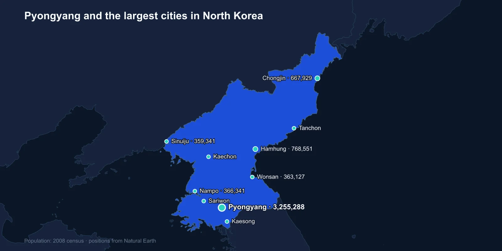
The largest cities in North Korea are Pyongyang (3,255,288), Hamhung (768,551), Chongjin (667,929), Nampo (366,341), Wonsan (363,127), Sinuiju (359,341), Tanchon (345,876), Kaechon (319,554), Kaesong (308,440) and Sariwon (307,764). These come from the 2008 census, which was conducted with United Nations technical assistance and is the most recent published count.
North Korea is more urban than most people assume — around sixty per cent of the population lives in towns and cities, a legacy of Soviet-style industrialisation. What makes its urban system unusual is that people cannot choose which city they live in.
Residence Is Assigned, Not Chosen
Movement within North Korea requires a travel permit, and permanent residence in Pyongyang is a status conferred by the state on the basis of political reliability, family background and occupation.
The songbun system classifies citizens by inherited loyalty into broad categories, and it governs access to education, employment and housing. The capital is reserved for the most favourably classified, and expulsion from Pyongyang to a provincial city or a rural county has been used as a punishment for decades — for individuals and, historically, for entire families.
The effect is a capital that functions as a showcase. Pyongyang has the electricity, the food supply, the metro and the monumental architecture, and its population is capped by policy rather than by the usual constraints of housing cost and employment.
A City Rebuilt From Nothing
Almost no pre-war Pyongyang survives. American bombing during the Korean War was extraordinarily heavy — the campaign dropped more ordnance on Korea than was used in the entire Pacific theatre of the Second World War — and by 1953 the city was largely rubble.
The reconstruction that followed, assisted by the Soviet Union, East Germany and China, produced a planned socialist capital: wide ceremonial avenues, Kim Il Sung Square laid out for parades, apartment blocks in coordinated colours, and later a series of monuments on a deliberately overwhelming scale — the Juche Tower, the Arch of Triumph built slightly larger than the one in Paris, and the 105-storey pyramid of the Ryugyong Hotel, begun in 1987 and still not opened.
The Pyongyang Metro runs very deep, doubling as a shelter, and its stations carry murals and chandeliers in a style closely comparable to Moscow's.
The Industrial Cities of the East Coast
Hamhung, the second city, is the centre of the chemical industry, built up around fertiliser and synthetic fibre plants established under Japanese rule and expanded afterwards with East German assistance. Vinalon, a synthetic fibre developed in Korea and promoted as a national material, is made there.
Chongjin in the far north-east is a steel city, and Tanchon is a mining and smelting centre for magnesite and non-ferrous metals — North Korea holds some of the world's largest magnesite reserves.
These cities were the hardest hit by the famine of the mid-1990s. The collapse of Soviet support ended the fuel and fertiliser supply that the whole system depended on, the public distribution system failed, and the north-eastern provinces — furthest from the capital and lowest in political priority — suffered the worst of it. Estimates of the death toll range widely, generally from several hundred thousand into the millions.
Ports, and What They Face
Nampo is Pyongyang's port, sitting at the mouth of the Taedong river about fifty kilometres downstream, connected by a motorway and by a long tidal barrage completed in 1986.
Wonsan on the east coast is a port and naval base, and it has been the focus of a sustained attempt to build a tourism economy — a ski resort at Masikryong, an airport rebuilt for international arrivals, and a large beach resort at Kalma that has been years in construction.
Beyond Wonsan lie the Kumgang mountains, long considered the most beautiful landscape on the peninsula and the site of a joint tourism venture with South Korea that ran from 1998 until a South Korean visitor was shot by a guard in 2008. The facilities sat unused for years and the North later announced it would demolish them.
Sinuiju sits on the Yalu directly across from Dandong in China, and the Friendship Bridge between them carries the overwhelming majority of North Korea's external trade. When that crossing closed almost entirely during the pandemic from 2020, the country's imports fell to a fraction of their previous level.
Kaesong, the Old Capital
Kaesong is the one city on this list with deep historical standing. It was the capital of the Goryeo dynasty from 918 to 1392 — the dynasty that gave Korea its English name — and its historic monuments, including the Manwoldae palace site, royal tombs and the Confucian academy, were inscribed by UNESCO in 2013.
It also sits just north of the Demilitarized Zone, and it was on the southern side of the line at the start of the Korean War, changing hands as a result of the armistice.
From 2004 the Kaesong Industrial Region operated there, with South Korean companies employing North Korean workers in a joint venture that was for a decade the most substantial economic cooperation between the two states. It was suspended in 2016, and the inter-Korean liaison office in the city was demolished by the North in 2020.
The Markets the State Did Not Plan
The famine broke the command economy in practice if not in law. When the public distribution system stopped delivering, people survived by trading, and the informal markets known as jangmadang spread across every city on this list.
They have since been partially legalised and taxed, and satellite imagery has been used by outside researchers to count several hundred official market sites across the country and to track their expansion. A substantial share of urban households now depends on market income rather than on state allocation.
This is the most significant change in North Korean urban life since the 1950s, and it is not visible in any census.
The trade has also produced a class of women traders who earn more than their assigned-workplace husbands, since men remain tied to state jobs that often pay nothing. Defector accounts consistently describe this as the largest social change of the past three decades, and it has happened entirely outside the official economy that the city plans were built around.
Sariwon, Kaechon and the Provincial Centres
Sariwon is the capital of North Hwanghae province in the agricultural south-west, the country's main grain-producing region, and it has a reconstructed folk village built in traditional style as a showpiece.
Kaechon, in South Pyongan, is a coal-mining and industrial town on the rail line north of the capital. It is also known outside the country for a reason its census entry does not record: the detention facilities in the surrounding district are among those most consistently documented in defector testimony and in the 2014 United Nations commission of inquiry.
The pairing is characteristic of the North Korean urban list. These are ordinary provincial capitals and industrial towns, and the institutions that make them internationally known appear in no official statistic.
A Country Lit by Almost Nothing
The single most reproduced image of North Korean geography is the satellite night-lights composite, in which the country appears as a dark gap between the dense illumination of South Korea and north-eastern China, with one small bright patch at Pyongyang.
It is a genuine measurement rather than a rhetorical device, and it maps the electricity problem precisely. Generating capacity is largely hydroelectric and coal-fired, both degraded, and supply outside the capital is intermittent enough that provincial cities run on a few hours a day.
The same imagery has become a research tool: outside analysts use changes in night-time light, alongside commercial satellite photography, to track construction, market activity and industrial output in cities that publish no data of their own.
What the 2008 Census Actually Was
The 2008 count was genuinely conducted with UN Population Fund support, and its raw tables were published, which makes it far more useful than outside observers initially expected. It recorded a national population of 24.05 million.
It has limits. Military personnel were handled in a way that is not transparent, and certain populations — including those held in the detention camp system documented by satellite imagery and defector testimony — are not separately identifiable in the results.
A further census was reportedly prepared for 2018 and its results have not been released. The 2008 figures therefore remain the working basis for any ranking of North Korean cities.
One further caution applies to the city figures specifically. North Korean urban units often include substantial rural territory within their administrative boundaries, and Pyongyang's has been redrawn more than once — counties were transferred out of the capital in 2010, reducing its area and its population on paper without anybody moving.
A System Planned Rather Than Grown
North Korea's urban ranking describes a planned system rather than an organic one: a capital rebuilt from rubble and restricted by permit, a chemical city and a steel city on the east coast, a port for the capital, a border city carrying nearly all the country's trade, and a former dynastic capital on the edge of the world's most fortified frontier.
What became of the churches and temples these cities once held is the subject of religion in North Korea. The Pyongyang profile covers the rebuilt capital, and the mountains, rivers and borders of the peninsula are in our North Korea country guide.
