
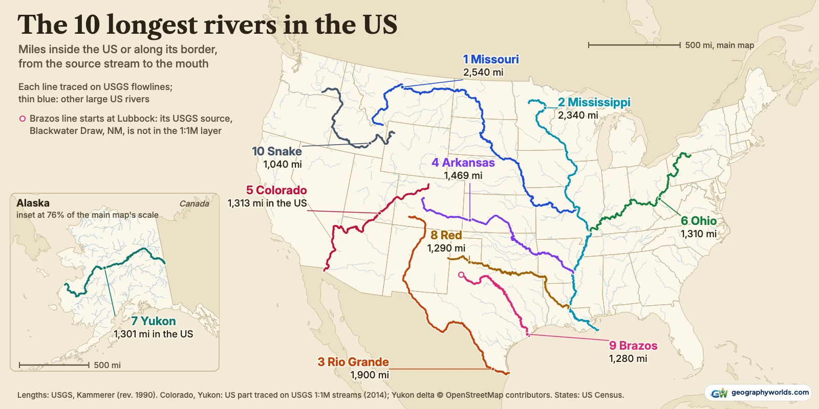
The 10 longest rivers in the US, in order, are the Missouri at 2,540 miles (4,090 km), the Mississippi at 2,340 (3,770 km), the Rio Grande at 1,900 (3,060 km), the Arkansas at 1,469, the Colorado at 1,313 (its US part), the Ohio at 1,310, the Yukon at 1,301 (its Alaska part), the Red at 1,290, the Brazos at 1,280 and the Snake at 1,040 miles. Each is measured from the source stream the US Geological Survey names to the river’s own mouth, and only the miles inside the United States or along its border count. The lengths are from the USGS table Largest Rivers in the United States, compiled by J.C. Kammerer and last revised in May 1990. For the Colorado and the Yukon, which cross into Mexico and out of Canada, we traced the US part ourselves on the USGS National Atlas 1:1,000,000 stream lines published in 2014, which also drew the map above; that layer stops at the head of the Yukon delta, so the last 46 miles come from OpenStreetMap.
Five of the ten belong to the Mississippi basin. Two more reach the Gulf of Mexico on their own, and the last three end in Mexico, the Bering Sea and the Columbia.
| # | River | Length in the US | Measured from | Ends in | States | Note |
|---|---|---|---|---|---|---|
| 1 | Missouri | 2,540 miles (4,090 km) | Red Rock Creek, Montana (Beaverhead County) | Mississippi, above St. Louis | 7 | USGS length, 1990 |
| 2 | Mississippi | 2,340 miles (3,770 km) | Mississippi River, Minnesota (Clearwater County) | Gulf of Mexico | 10 | USGS length, 1990 |
| 3 | Rio Grande | 1,900 miles (3,060 km) | Rio Grande, Colorado (San Juan County) | Gulf of Mexico | 3 | all in the US or on the Mexican border |
| 4 | Arkansas | 1,469 miles (2,360 km) | East Fork Arkansas River, Colorado (Lake County) | Mississippi | 4 | USGS length, 1990 |
| 5 | Colorado | 1,313 miles (2,110 km) | Colorado River, Colorado (Grand County) | Mexico (Gulf of California) | 5 | US part; 1,450 to the Gulf of California |
| 6 | Ohio | 1,310 miles (2,110 km) | Allegheny River, Pennsylvania (Potter County) | Mississippi, at Cairo | 7 | USGS length, 1990 |
| 7 | Yukon | 1,301 miles (2,090 km) | McNeil River, Yukon Territory, Canada | Bering Sea | 1 | Alaska part; 1,980 in all |
| 8 | Red | 1,290 miles (2,080 km) | Tierra Blanca Creek, New Mexico (Curry County) | Atchafalaya | 5 | USGS length, 1990 |
| 9 | Brazos | 1,280 miles (2,060 km) | Blackwater Draw, New Mexico (Curry County) | Gulf of Mexico | 2 | USGS length, 1990 |
| 10 | Snake | 1,040 miles (1,670 km) | Snake River, Wyoming (Teton County) | Columbia | 4 | USGS length, 1990 |
Where a river starts and stops on this list
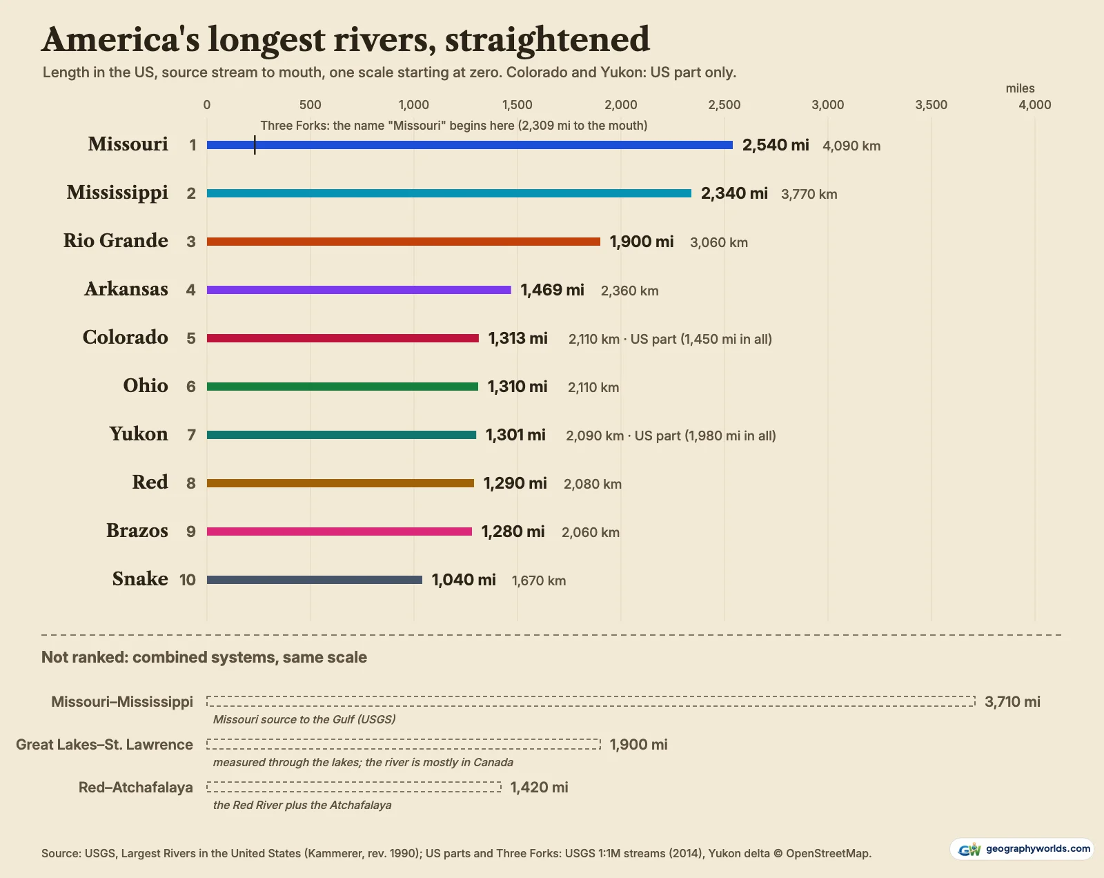
Rivers change names on the way down, so a length depends on where you start. USGS measures from the stream it treats as the source, whatever that stream is called. The Missouri’s source, in its table, is Red Rock Creek, Montana (Beaverhead County). Our trace from that creek runs through Red Rock River, Clark Canyon Reservoir, the Beaverhead and the Jefferson before the water is called the Missouri at all, and it comes to 2,540 miles, the same as the published figure. The Ohio is counted from the Allegheny River, Pennsylvania (Potter County): the Allegheny dips into New York before it reaches Pittsburgh, which is why the Ohio’s list of states, Pennsylvania, New York, Ohio, West Virginia, Kentucky, Indiana and Illinois, includes one that the Ohio itself never touches.
Each river ends where it loses its name. The Missouri ends above St. Louis, so it is one entry and the Mississippi is another. Run them together and USGS gets 3,710 miles (5,970 km) from Montana to the Gulf, but that is a system, not a river, and it stays off the ranking along with two others: the Red–Atchafalaya (1,420 miles, the Red plus the Atchafalaya) and the Great Lakes–St. Lawrence (1,900 miles, measured from the North River in Minnesota through all the lakes).
Missouri and Mississippi: two entries, 200 miles apart
On USGS figures the Missouri beats the Mississippi by 200 miles. Most of that margin is headwater: under its own name, from Three Forks, the Missouri runs 2,309 miles (3,720 km) on our trace, so the creeks and rivers above Three Forks add 231 miles. The National Park Service, which gives the Mississippi 2,350 miles from Lake Itasca, calls the Missouri “about 100 miles longer” on its Mississippi River facts page, without saying where it starts the Missouri; our Missouri versus Mississippi comparison finds the two almost level by name alone.
The same NPS page lists three published lengths for the Mississippi: 2,300 miles from USGS, 2,320 from the EPA and 2,350 from the Mississippi National River and Recreation Area. Between 1766 and 1885, 18 cutoffs across meander necks shortened the river between Cairo and New Orleans by 218 miles. Our trace of the Mississippi on the 2014 stream lines, from Clearwater County, Minnesota, to the Gulf, gives 2,287 miles through ten states. The Missouri touches seven: Montana, North Dakota, South Dakota, Nebraska, Iowa, Missouri and Kansas.
Arkansas, Ohio and Red: the basin’s long arms
The Arkansas rises as the East Fork Arkansas River, Colorado (Lake County) and runs 1,469 miles (2,360 km) through Colorado, Kansas, Oklahoma and Arkansas to the Mississippi. It drains 161,000 square miles (417,000 km²), yet by USGS figures delivers only 41,000 cubic feet per second at its mouth.
The Ohio is 159 miles shorter, at 1,310 miles (2,110 km), and carries far more water. Its average discharge of 281,000 cubic feet per second (8,000 m³/s) is 3.7 times the Missouri’s 76,200, from a basin of 203,000 square miles against the Missouri’s 529,000. At Cairo, Illinois, it brings the Mississippi a flow equal to 47% of the Mississippi’s own at the Gulf, as USGS counts it.
The Red River starts as Tierra Blanca Creek, New Mexico (Curry County), becomes the Prairie Dog Town Fork, and runs 552 miles along the Texas–Oklahoma line on our trace before turning into Louisiana: 1,290 miles (2,080 km) through New Mexico, Texas, Oklahoma, Arkansas and Louisiana. It ends where it meets the Atchafalaya, so USGS also lists an “Atchafalaya” of 1,420 miles that begins at the same creek.
The Brazos across Texas, the Snake to the Columbia
Apart from its headwater draw, the Brazos is a Texas river. USGS starts it at Blackwater Draw, New Mexico (Curry County), just over the state line, and gives it 1,280 miles (2,060 km) to the Gulf of Mexico. Our trace is shorter, 1,155 miles, because the 1:1,000,000 stream lines do not carry Blackwater Draw, so the published length is the one ranked.
The Snake, tenth at 1,040 miles (1,670 km), rises in Teton County, Wyoming, crosses southern Idaho, follows the Idaho–Oregon line for 224 miles on our trace and joins the Columbia in Washington. The Platte, at 990 miles, is the eleventh-longest river on the USGS list:
Length against discharge
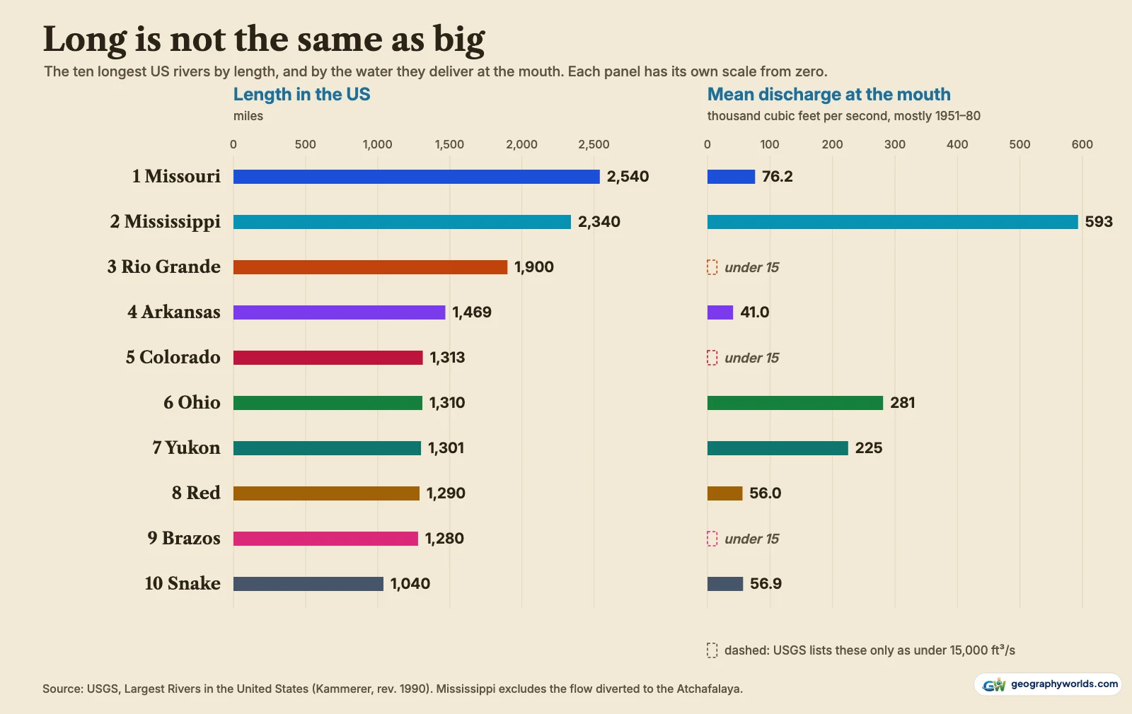
By water delivered, the order turns over. The Mississippi averages 593,000 cubic feet per second (16,800 m³/s), 2.1 times the Ohio, and the Yukon is third at 225,000 (6,400 m³/s). USGS gauges keep that order on more recent records: water-year means of 569,000 at Baton Rouge (19 water years, 2005–2024), 279,000 on the Ohio at Metropolis (1929–2014), 237,000 on the Yukon at Pilot Station (45 water years, 1976–2025, with a gap in 1997–2001) and 88,900 on the Missouri at Hermann (1958–2025).
Three of the ten were too small for the USGS discharge ranking, which listed only rivers above 15,000 cubic feet per second: the Rio Grande, the Colorado and the Brazos. On USGS records for water years 1991–2020, the Brazos near Rosharon averaged 9,070 cubic feet per second and the Colorado above Morelos Dam, at the Mexican border, 2,420. The USGS table notes that diversions cut the Colorado’s flow near its mouth from about 22,000 cubic feet per second in 1903–34 to less than 4,000 in 1951–80. Near Brownsville, the Rio Grande’s median daily flow in water years 1996–2000 was 69 cubic feet per second.
Cut at the border: Rio Grande, Colorado, Yukon and Columbia
The Rio Grande loses nothing. It rises in San Juan County, Colorado, and from El Paso to the Gulf it is the boundary: the International Boundary and Water Commission puts that reach at 1,255 miles, and our trace makes it 1,240. All 1,900 miles (3,060 km) of the USGS length therefore count.

The Colorado runs 1,450 miles from Grand County, Colorado, to the Gulf of California. It follows the boundary for 24 miles, by the IBWC’s count (24 on our trace), then leaves for Mexico. Traced from its source to that point, the US part is 1,313 miles (2,110 km) through Colorado, Utah, Arizona, Nevada and California. Against the Ohio’s published 1,310, which USGS rounds, the two are level; trace against trace, the Colorado leads by 19 miles.
The Yukon is 1,980 miles long on the USGS table, starting at the McNeil River, Yukon Territory, Canada. From the 141st meridian the USGS stream lines run 1,255 miles and stop at the head of the delta; the river’s own OpenStreetMap channel adds 46 miles to the Bering Sea, for 1,301 miles (2,090 km), seventh. The Canadian Encyclopedia puts 1,149 of its 3,185 km in Canada, which leaves about 1,265 miles for Alaska; on that figure the Yukon would drop behind the Red and the Brazos.
The Columbia falls out altogether. Its USGS length is 1,249 miles, but it rises in British Columbia; the USGS stream lines run 687 miles from the border and stop above the estuary, and OpenStreetMap’s channel adds 49 to the Pacific, for 736. The Northwest Power and Conservation Council places the border at River Mile 749. On either number it is well short of the Snake, its own tributary. For the whole-continent picture, with the Mackenzie and the full Yukon, see our list of the longest rivers in North America.
How old these numbers are
The USGS lengths date from the 1990 revision, and the table itself warns that some of its data are provisional. We checked them against the 2014 stream lines: for the seven ranked rivers that never leave the US, apart from the Brazos, the traced length was between −4% and +2% of the published one.
The ranking is solid at the top and loose in the middle. Ranks five to nine lie within 33 miles of each other; the Yukon leads the Red by 11 miles and the Red the Brazos by 10. The first four are safer: the Arkansas leads the next river by 156 miles.
You can download the data as a CSV with every river’s US length, the published total, our traced length, source stream, states and USGS discharge; dropped into Parity, those columns become a length-against-flow chart of your own in a few clicks.
The Rio Grande, the only one of the ten that is an international border for most of its length, has its own guide to the Rio Grande, from its source in San Juan County, Colorado, to the Gulf.
Sources
- USGS, Largest Rivers in the United States (J.C. Kammerer, Open-File Report 87-242, rev. May 1990): lengths, drainage areas and discharge (mostly 1951–80); US government work, public domain
- USGS National Atlas, 1:1,000,000-Scale Streams of the United States (March 2014): flowlines used to trace and draw every river; metadata: access and use constraints 'None'
- USGS National Water Information System, annual statistics: water-year mean discharge at Baton Rouge, Metropolis, Pilot Station, Hermann, the Northerly International Boundary and Rosharon
- USGS NASQAN summary statistics, Rio Grande near Brownsville (WRI 01-4255): daily flow, water years 1996–2000
- International Boundary and Water Commission, About us: boundary lengths along the Rio Grande and Colorado
- National Park Service, Mississippi River facts: published lengths of the Mississippi
- The Canadian Encyclopedia, Yukon River: length in Canada
- Northwest Power and Conservation Council, Columbia River: border river mile and BC length
- OpenStreetMap: Yukon River way 45394137 and Columbia River way 905085019: delta and estuary reaches below the end of the USGS 1:1M lines; © OpenStreetMap contributors, ODbL
- US Census Bureau state boundaries via us-atlas: map outlines, public domain
- Natural Earth via world-atlas: Canada and Mexico outlines, public domain