

Six countries surround landlocked Ethiopia: Eritrea to the north, Djibouti and Somalia to the east, Kenya to the south, and South Sudan and Sudan to the west. Wikipedia's articles on each border put the six lines at roughly 5,600 km in total, from about 1,500 km with Somalia down to 375 km with Djibouti, though published figures differ because parts of the Somali and Sudanese frontiers have never been fully demarcated. Ethiopia has had no coastline and so no sea neighbours since Eritrea became independent in 1993, and more than 95% of its trade now passes through Djibouti. That makes each of these six borders, and the de facto line with Somaliland inside Somalia, matter more than the map suggests.
Eritrea: roughly 1,033 km, Badme and twenty years of closed crossings
The northern border runs about 1,033 km along the edges of Ethiopia's Tigray and Afar regions, and stretches of it follow rivers: the Mareb, also called the Gash, which is dry for much of the year but floods suddenly in the rainy season, and, in the far west, the Tekezé, whose canyon is the deepest in Africa, more than 2,000 m deep in places. Its origin is Italian. The Treaty of Wuchale of 2 May 1889 recognised Italian Eritrea, but its Amharic and Italian texts disagreed about whether Ethiopia had become an Italian protectorate. Emperor Menelik II won the war that followed, and the Treaty of Addis Ababa of 1896 left Italy the land beyond the Mareb, Belesa and Muna rivers.
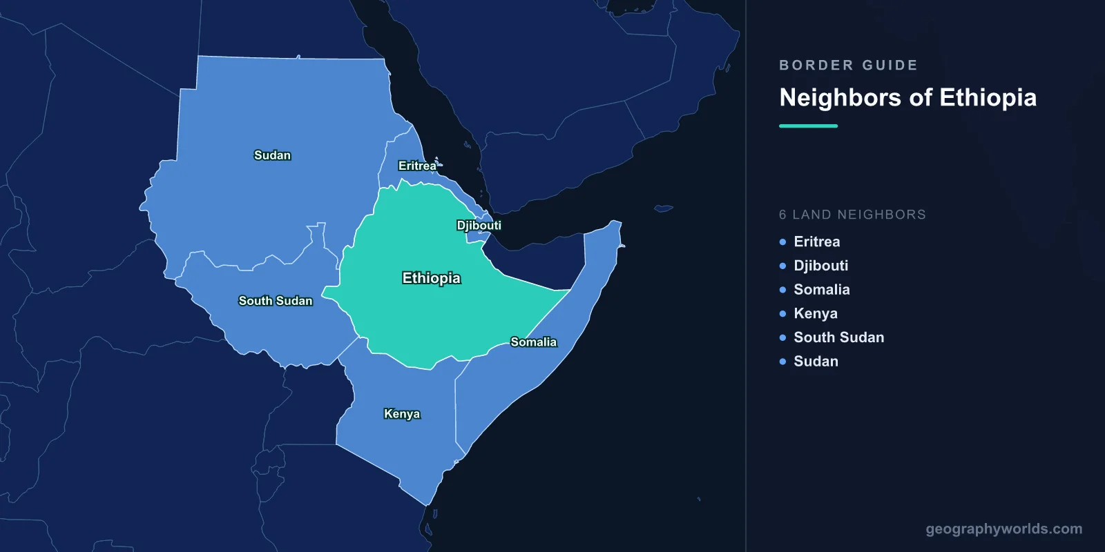
Eritrea was federated with Ethiopia in 1952, fought a long war of independence led first by the Eritrean Liberation Front and later by the Eritrean People's Liberation Front, and voted 99.81% for independence in a UN-sponsored referendum before becoming a sovereign state on 24 May 1993. The line then became a war zone. Fighting that began over the town of Badme lasted from May 1998 to June 2000 and ended with the Algiers Agreement of 12 December 2000. In April 2002 the Eritrea–Ethiopia Boundary Commission set up under that agreement awarded Badme to Eritrea, but Ethiopia refused to recognise the decision, leaving a state of "no war, no peace" with the crossings shut and telephone lines cut. At a summit in Asmara on 8–9 July 2018, President Isaias Afewerki and Prime Minister Abiy Ahmed declared the conflict over and Ethiopia said Badme would go to Eritrea; on 11 September 2018 the crossings at Serha–Zalambessa and Debaysima–Burre reopened for the first time since 1998. The alliance held into the Tigray war that began in November 2020, when Eritrean troops were reported fighting alongside Ethiopia's army, but relations have since deteriorated again as Eritrea has sided with Somalia in Ethiopia's dispute with Mogadishu. Our Eritrea guide looks at the country on the other side.
Djibouti: 375 km and the railway to the Red Sea
The shortest border runs 375 km from the Eritrean tripoint on Mount Mousa Ali to the Somali tripoint. It dates from the 1897 agreement that defined French Somaliland, was marked on the ground by a joint French–Ethiopian commission in the early 1950s, and has no disputed sections. The Awash River ends on this border in Lake Abbe, a hypersaline lake with no outflow, fringed by salt flats and known for its flamingos.
For Ethiopia this is the most important line on the map. More than 95% of its trade passes through Djibouti, making up about 70% of the port's business, and the standard-gauge Addis Ababa–Djibouti Railway, inaugurated on 1 January 2018, links the capital to the Port of Doraleh. Its full capacity is 24.9 million tonnes of freight a year, but traffic has run far below that, and in 2019 the line earned about US$40 million against operating costs of about US$70 million. The road crossings are at Galafi in the west, Dewele in the south-west and, since 20 September 2020, Balho in the north. A border trade protocol signed in 2015 also lets people in the frontier districts trade small quantities of goods across the line, and the two governments held their first joint border trade committee in April 2022. Our page on Djibouti City describes the port end of the corridor.

Somalia: about 1,500 km, the Ogaden and an unfinished line
The longest border curves around Ethiopia's Somali Region, from the Djibouti tripoint to the meeting point with Kenya in the Dollo area, close to where the Dawa and Genale rivers meet. It was drawn by deals between Menelik and the colonial powers, above all the 1897 Anglo-Ethiopian treaty, under which Britain ceded Somali territory to Menelik in return for his help against Somali clans, and, in the south, the 1907 Anglo-Ethiopian agreement that set the corner where the Dawa and Genale rivers meet. After the Second World War Britain ran the Ogaden and the Haud until it handed them back to Ethiopia between 1948 and 1954. The central section was never fully demarcated and is still shown on many maps as a provisional administrative line.
Somalia's claim to the Ogaden after its independence in 1960 led to clashes in 1964 and to the Ogaden War of July 1977 to March 1978, in which Ethiopia, backed by Soviet supplies and more than 12,000 Cuban troops, pushed back the army of Siad Barre's Somalia, which lost almost a third of its regular soldiers and half its air force; the Ethiopian government declared the last border post retaken on 23 March 1978. Since 1994 the land on the Ethiopian side has formed the Somali Regional State. The two governments fell out again in 2024 and agreed in Ankara on 12 December 2024 to restore relations.
Somaliland: the Tog Wajaale crossing and the 2024 port deal
The northern part of the Somali border is controlled by Somaliland, a self-declared state that Somalia and most of the world regard as part of Somalia. Its main crossing is at Tog Wajaale, with the Ethiopian settlements of Togo Wuchale and Wajaale about 20 km to the south-west. It is Somaliland's main crossing for goods, most of them moving to and from the port of Berbera. On 1 January 2024 Ethiopia and Somaliland signed a memorandum of understanding whose text was never published; Somaliland's president said it leased more than 19 km of coastline to Ethiopia for 50 years, and it reportedly included a provision for future Ethiopian recognition of Somaliland. Somalia recalled its ambassador in protest. The Ankara Declaration of 12 December 2024 did not mention the memorandum, Ethiopia has not confirmed cancelling it, and Somaliland maintains that it still stands.
Kenya: 861 km, Moyale and the Ilemi Triangle
The southern border runs 861 km past Kenya's Mandera, Wajir, Marsabit and Turkana counties and Ethiopia's Borena and Dawa zones. Britain first identified it in 1907, it was redefined in 1947 after the East African Campaign and demarcated in the 1950s, and independent Kenya and Ethiopia approved it in 1970. Much of the borderland is remote from both capitals, with poor roads, high poverty and recurrent drought, which is why the two governments run joint cross-border development programmes there. The main crossing is Moyale, a town split between the two countries on the Nairobi–Addis Ababa road, on the southern escarpment of the Borana Plateau north of the Chalbi Desert.

At the western end, the Omo River runs some 760 km, falling about 700 m from the confluence of the Gibe and Wabe rivers, before it empties into the north end of Lake Turkana, on the border, supplying most of the lake's water, and the Daasanach, Nyangatom and Turkana herders move across the line in search of pasture; clashes among them killed about 600 people between 1989 and 2011. Beyond lies the Ilemi Triangle, about 11,000 km² claimed by both Kenya and South Sudan and controlled by Kenya. Ethiopia makes no claim to it, having accepted it as Sudanese territory in treaties of 1902, 1907 and 1972.
South Sudan: about 1,114 km around the Gambela lowlands
The western frontier was set by Britain and Emperor Menelik in May 1902, when Sudan was an Anglo-Egyptian condominium. About 1,114 km of it now divides Ethiopia from South Sudan, wrapping around the lowland Gambela Region, which lies between the Openo and Akobo rivers and was confirmed as Ethiopian by the 1902 line; Gambella National Park there, at 5,016 km², is Ethiopia's largest. After South Sudan's independence in 2011 the two states signed a border agreement in Addis Ababa on 27 September 2012.
Sudan: 744 km, al-Fashaga and the Metemma crossing
The 744 km border with Sudan is more contested. Relations swung between hostility, when Sudan backed Eritrean rebels in the 1960s and Ethiopia backed southern Sudanese ones in return, and mediation, when Addis Ababa hosted the conference that ended Sudan's first civil war on 17 February 1972. In a circular of 15 April 1891 Menelik claimed land as far as Khartoum, and the 1902 treaty line was surveyed by the British engineer Charles Gwynn without Ethiopian officials present. The fertile al-Fashaga district, where Ethiopia claims land up to the Atbarah and Tekezé rivers, has been disputed ever since, and a clash there on 15 December 2020 turned violent. The towns of Metemma in Ethiopia and Gallabat in Sudan face each other across the line; at the Battle of Gallabat on 9–10 March 1889, Emperor Yohannes IV was killed fighting the Mahdist army. Close to this border, in Benishangul-Gumuz, stands the Grand Ethiopian Renaissance Dam on the Blue Nile, formally inaugurated on 9 September 2025 with 5.15 GW of capacity, the largest hydropower plant in Africa. Water and trade from the Ethiopian Highlands flow down to all six of these neighbours, across borders that run mostly through the lowlands below the plateau's edge.