
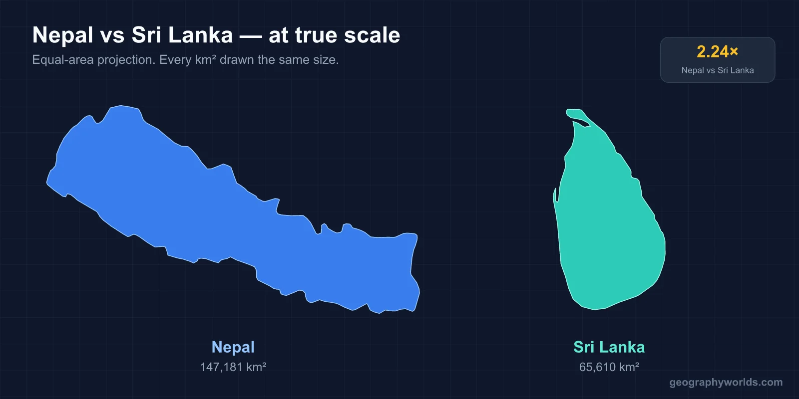
Nepal covers 147,181 km² to Sri Lanka's 65,610 km², about 2.2 times the area, and has roughly 29.6 million people to Sri Lanka's 22 million. Nepal is landlocked and rises to 8,849 metres; Sri Lanka is an island whose highest point reaches 2,524 metres. The most counter-intuitive difference is religious: the Buddha was born in Nepal, but Nepal is over 80% Hindu, while Sri Lanka — 2,000 kilometres away — is around 70% Buddhist.
The numbers, side by side
| Measure | Nepal 🇳🇵 | Sri Lanka 🇱🇰 |
|---|---|---|
| Area | 147,181 km² | 65,610 km² |
| Population | ~29.6 million | ~22 million |
| Coastline | None — landlocked | ~1,340 km |
| Capital | Kathmandu | Sri Jayawardenepura Kotte (Colombo is the commercial centre) |
| Official languages | Nepali | Sinhala and Tamil |
| Majority religion | Hinduism (~81%) | Buddhism (~70%) |
| Highest point | Mount Everest, 8,849 m | Pidurutalagala, 2,524 m |
| Currency | Nepalese rupee | Sri Lankan rupee |
Vertical country, horizontal country
Nepal's defining statistic is not its area but its range. It runs from about 59 metres above sea level in the southeastern Terai to 8,849 metres at the summit of Everest, and the distance between those two points is under 200 kilometres. No country packs a larger altitude span into so little horizontal distance.
Sri Lanka's relief is gentler and arranged in rings. A broad coastal plain surrounds the Central Highlands, which rise to Pidurutalagala at 2,524 metres near Nuwara Eliya. Adam's Peak — Sri Pada — is lower at 2,243 metres but far more prominent culturally, being a pilgrimage site claimed by Buddhists, Hindus, Muslims and Christians simultaneously. The depression at its summit is read as the Buddha's footprint, Shiva's, Adam's or St Thomas's depending on who is climbing, and the pilgrimage season runs from December to May with a night ascent timed to reach the top at dawn.
Those highlands also do the island's climatic work. They intercept both monsoons, which is what creates the wet-zone and dry-zone division described below, and their elevation gave the British the cool conditions that made large-scale tea planting possible at a latitude of six degrees north.
Being an island changes everything downstream. Sri Lanka has about 1,340 kilometres of coastline, ports that have mattered to Indian Ocean trade for two millennia, and a fishing sector. Nepal has none of that, and routes effectively all of its trade overland through India.
How the rain arrives, and why it matters more in Sri Lanka
Both are monsoon countries, but they receive the monsoon differently.
Nepal has one dominant wet season: the southwest summer monsoon from roughly June to September, which delivers the large majority of annual rainfall and is intercepted by the Himalayan wall. That wall casts a rain shadow, which is why the trans-Himalayan districts of Mustang and Dolpo are arid while the middle hills are lush.
Sri Lanka gets two. The Yala monsoon arrives from the southwest between May and September and soaks the western and southern coasts; the Maha monsoon comes from the northeast between roughly December and February and waters the north and east. The result is that the island is split into a permanently wet zone in the southwest and a dry zone across the north and east — and that there is no single month when the whole country is in season, which is the main thing to understand about when to visit.
The religious inversion
This is the comparison's most surprising result. Lumbini, in Nepal's Terai, is the Buddha's birthplace and a UNESCO World Heritage Site. Yet Nepal's 2021 census recorded 81.19% of the population as Hindu and only 8.21% as Buddhist.
Sri Lanka runs the other way: roughly 70% Buddhist, with Hindus at about 12.6%, Muslims near 9.7% and Christians around 7.4%. Theravada Buddhism reached the island in the third century BCE and the Sinhalese chronicles have carried it since.
The explanation is that Buddhism largely receded from its region of origin over the following millennium while taking permanent root elsewhere, and that in Nepal the boundary between Hindu and Buddhist practice is genuinely blurred rather than contested — many Nepalis worship at sites both traditions claim. Our guide to religion in Nepal covers that overlap in detail.
One capital, and one country that has two
Kathmandu is unambiguously Nepal's capital: seat of government, largest city, cultural centre, all in one valley.
Sri Lanka splits the role. The legislative capital is Sri Jayawardenepura Kotte, a suburb southeast of Colombo, where parliament moved in 1982. Colombo remains the commercial capital, the largest city and the place almost everyone means when they say the capital. It is one of a small set of countries that keeps its legislature and its commercial hub deliberately apart.
Who lives there, and in which language
Nepal is one of the most linguistically fragmented countries in Asia relative to its size. Nepali is the sole official language of the federal state, but more than 120 others are spoken, spread across Indo-Aryan languages in the south and Tibeto-Burman languages through the hills and high north. Ethnic and caste identity maps closely onto that pattern — Bahun and Chhetri, Newar in the Kathmandu Valley, Magar, Tharu in the Terai, Tamang, Rai, Limbu, Gurung and the Tibetan-descended communities of the far north.
Sri Lanka's diversity is smaller in number and much sharper in political consequence. Sinhala speakers are roughly three-quarters of the population and Tamil speakers about a quarter, and both Sinhala and Tamil are official languages, with English as a designated link language. The Tamil-speaking population divides between Sri Lankan Tamils, concentrated in the north and east and long established there, and Indian Tamils brought to the highlands as plantation labour in the nineteenth century.
The difference is structural. Nepal's many languages are not organised into two blocs facing each other, so its politics fragment along several axes at once. Sri Lanka's split into two large linguistic communities produced a binary that the state's post-independence language policy — making Sinhala the sole official language in 1956 — turned into the central grievance behind the civil war.
An island on a shipping lane, and a country with no coast
Sri Lanka sits just off the southern tip of India, separated from it by the Palk Strait and the Gulf of Mannar. Between the two runs Adam's Bridge, a chain of shoals and sandbanks — called Rama's Setu in Hindu tradition — shallow enough to block shipping, which is why vessels round the island rather than cutting through.
That position put Sri Lanka on the main east-west route across the Indian Ocean for two thousand years, and it still does: Colombo is one of South Asia's busiest container ports and a significant transhipment hub. Being on that lane is the reason the island has been contested by outside powers repeatedly, from Portuguese and Dutch coastal control to British annexation of the whole island in 1815, and it is the reason its ports attract strategic interest today.
Nepal has the mirror-image problem. With no coast and a Himalayan wall to the north, effectively all of its trade moves overland through India, which makes its economy structurally exposed to that single relationship — as the 2015 border blockade demonstrated. Landlockedness is not a neutral fact for Nepal; it is a permanent constraint on its foreign policy.
What each country lives on
Sri Lanka's export identity is agricultural and coastal: tea above all — Ceylon tea is still marketed under the pre-1972 name — along with garments, rubber, spices and tourism. The Central Highlands were converted to tea in the nineteenth century after coffee blight, and the labour brought in for it is the origin of the island's Indian Tamil community.
Nepal's economy leans on agriculture, tourism and, above all, remittances from citizens working abroad, which make up an unusually large share of GDP — among the highest ratios of any country. Most of that money comes from workers in the Gulf states, Malaysia and India, and the outflow of working-age men has reshaped rural Nepal, leaving many hill villages run by women, children and the elderly.
Sri Lanka has a labour-export economy too, concentrated in the Gulf and historically weighted towards women in domestic work, but it is a smaller share of national income than Nepal's and sits alongside a genuine manufacturing base. The garment sector employs hundreds of thousands and is the island's largest industrial export earner, which is something Nepal has never managed to build at scale — partly because landlocked freight costs make export manufacturing hard to compete on.
Both have had a hard recent quarter-century. Sri Lanka came through a civil war that ran from 1983 to 2009, the 2004 Indian Ocean tsunami that killed more than 30,000 people on the island, and a sovereign default in 2022. Nepal fought a civil war from 1996 to 2006, abolished its monarchy in 2008, and lost around 9,000 people in the 2015 Gorkha earthquake.
Which is bigger, and in what sense
By area and population, Nepal. By coastline, ports and access to the sea, Sri Lanka wins by default. By vertical extent it is not close — Everest alone is more than three times Sri Lanka's highest point.
The more useful framing is that these are not really the same kind of country. Nepal is a mountain state whose geography is organised by altitude and whose external relations are shaped by having no coast. Sri Lanka is a maritime state whose geography is organised by rainfall zones and whose history is shaped by sitting on the Indian Ocean's main east-west route. For more on each, see Nepal geography and Sri Lanka geography.
