

Introduction
At its peak in the 16th and 17th centuries, the Spanish Empire encompassed approximately 13.7 million square kilometers across four continents, making it the first truly global empire — and the first "empire on which the sun never set." From Patagonia to California, from the Philippines to the Netherlands, Spanish territory circled the globe.
Unlike the land-based empires of Asia, Spain's empire was fundamentally oceanic. Mastery of the Atlantic Ocean, control of Caribbean island staging points, and the development of reliable transoceanic sailing routes transformed a medium-sized European kingdom into the world's first global colonial power.
Territory & Extent
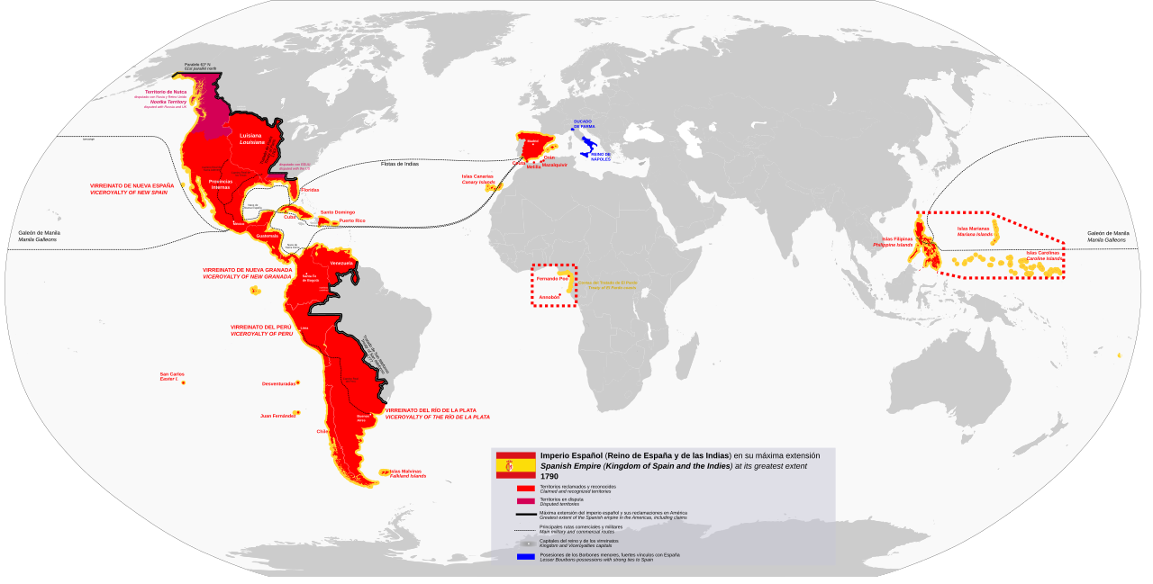
The Spanish Empire included modern Spain, much of the Americas (from Argentina and Chile in the south to California and Florida in the north), the Philippines, portions of Italy, the Netherlands (briefly), Portugal and its colonies (1580-1640), and various African coastal possessions including the Canary Islands, Ceuta, and Melilla.
In the Americas, Spanish territory was organized into viceroyalties: New Spain (Mexico, Central America, Caribbean, Philippines), Peru (western South America), New Granada (northern South America), and Río de la Plata (southern South America). These administrative divisions would later become the template for independent Latin American nations.
Key Geographic Features
- Atlantic Ocean: Mastery of Atlantic sailing routes was the foundation of Spanish imperial power. The Canary Islands served as the critical waypoint where ships caught the trade winds to cross to the Americas.
- Caribbean Islands: Cuba, Hispaniola, Puerto Rico, and Jamaica served as staging points for conquests on the mainland and as defensive bastions protecting the sea lanes of the empire.
- Andes Mountains: The Andes contained the empire's greatest source of wealth — the silver mines of Potosí (in modern Bolivia), which produced roughly 60% of the world's silver in the late 16th century.
- Central American Isthmus: The narrow land bridge between North and South America was a critical geographic feature, with Panama serving as the transshipment point for silver traveling from Peru to Spain.
- Philippine Archipelago: Spain's Pacific outpost, comprising over 7,000 islands, provided access to the lucrative Asian spice and silk trade and served as the western terminus of the Manila Galleon route.
Trade Routes & Strategic Locations
- Manila Galleon Route: One of the most remarkable trade routes in history, connecting Manila in the Philippines to Acapulco in Mexico across the Pacific Ocean. This route operated continuously for 250 years (1565-1815), carrying Asian silk, spices, and porcelain to the Americas and European silver to Asia.
- Silver Fleets (Flota de Indias): Heavily armed convoys that carried American silver from Havana to Seville, following the Gulf Stream and trade winds across the Atlantic. These fleets transported the wealth that made Spain the dominant European power.
- Strait of Magellan: The treacherous passage at the tip of South America connecting the Atlantic to the Pacific was a critical (if dangerous) route for circumnavigating the globe.
- Isthmus of Panama: Silver from Potosí was shipped up the Pacific coast to Panama, transported overland across the narrow isthmus, and then loaded onto Atlantic-bound ships at Portobelo — a geographic bottleneck that shaped global trade for centuries.
- Treaty of Tordesillas Line: The 1494 treaty divided the non-Christian world between Spain and Portugal along a geographic meridian, giving Spain claim to most of the Americas while Portugal received Brazil and the route to Asia around Africa.
Geographic Legacy
The Spanish Empire's geographic legacy is among the most visible of any empire in history. The borders of virtually every Latin American nation — from Mexico to Argentina — follow the administrative boundaries of Spanish colonial viceroyalties, audiencias, and captaincies general. These colonial divisions, drawn for administrative convenience, became the national borders that persist today.
The Philippines, named after King Philip II of Spain, bears the cultural and linguistic imprint of over 300 years of Spanish colonial rule. The global spread of the Spanish language — spoken by over 500 million people today across 20 countries — is a direct geographic consequence of the empire's territorial extent in the Americas.
Key Facts
- Peak territory: approximately 13.7 million km² — the first "empire on which the sun never set"
- The Manila Galleon route operated continuously for 250 years (1565-1815)
- Potosí's silver mines produced roughly 60% of the world's silver supply in the late 16th century
- Spanish colonial administrative borders became the national borders of 18 modern Latin American countries
- The Philippines is named after King Philip II of Spain, who ruled from 1556 to 1598
Fun Facts
- The Spanish Empire was the first empire to literally circle the globe, with territory on every inhabited continent and the Manila Galleon connecting its Pacific and Atlantic halves
- Potosí in modern Bolivia was once one of the largest and wealthiest cities in the world, with a population exceeding 200,000 — larger than London or Paris at the time — entirely because of its geographic location atop the world's richest silver deposits
- The Manila Galleon route operated for 250 continuous years — longer than the entire existence of the United States — carrying goods across 15,000 km of Pacific Ocean
- Colonial borders drawn by Spanish administrators in the 16th-18th centuries became the national borders of modern Latin American countries, often following rivers, mountain ridges, and other geographic features that are still boundaries today
- The Canary Islands, located off the coast of Africa, were the geographic key to the entire empire — their position in the Atlantic trade wind belt made them the essential last stop before the crossing to the Americas
Final Thoughts
The Spanish Empire demonstrated that control of ocean routes could be just as powerful as control of land. By mastering the Atlantic, establishing island staging points in the Caribbean, exploiting Andean mineral wealth, and linking it all through the Manila Galleon to Asian markets, Spain built the first truly global empire — one whose geographic legacy is still written in the borders, languages, and cultures of four continents.
