
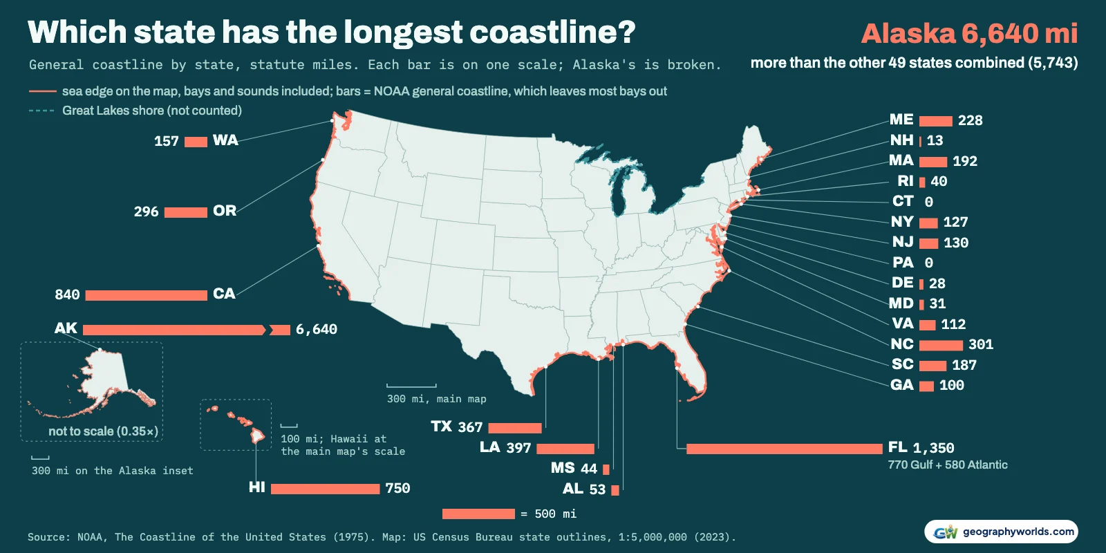
Alaska has the longest coastline of any US state, on both of the measures NOAA publishes: 6,640 statute miles (10,686 km) of general coastline, more than the other 49 states put together (5,743 miles), and 33,904 miles (54,563 km) of tidal shoreline. Florida is second on both, with 1,350 miles of general coastline and 8,436 miles of tidal shoreline. Below that the two rankings part ways. On the general coastline, California (840 miles) is third and Hawaii (750) fourth. On the tidal shoreline, Louisiana (7,721 miles) is third, Maine (3,478) fourth and California (3,427) fifth.
Why "longest coastline" has two official answers
Both numbers come from one NOAA publication, The Coastline of the United States (1975), and NOAA still uses The Coastline of the United States in the formulas that allocate its coastal grants, Maryland's natural resources department notes. They measure different lines. The general coastline follows the outline of the open coast. Its rule, as the 1980 Statistical Review of the U.S. Coastal Zone sets it out, takes in only sounds and bays whose entrances are wider than 30 miles, and only as far in as they stay that wide, so Chesapeake Bay and San Francisco Bay are left out. The tidal shoreline goes everywhere the tide does: the outer coast, offshore islands, sounds, bays, rivers and creeks, up to the head of tidewater or to the point where tidal water narrows to 100 feet, according to the note on NOAA's shoreline mileage table.
Adding up the 24 states that touch the ocean gives 12,383 miles (19,929 km) of general coastline and 88,633 miles of tidal shoreline (in the 1975 table, where Florida has 8,426). Alaska alone holds 54% of the first and 38% of the second. That is why the headline is safe either way, and why "Alaska has more coastline than all the other states combined" is true of the general coastline only: on the tidal measure the other 23 have 54,729 miles to Alaska's 33,904.
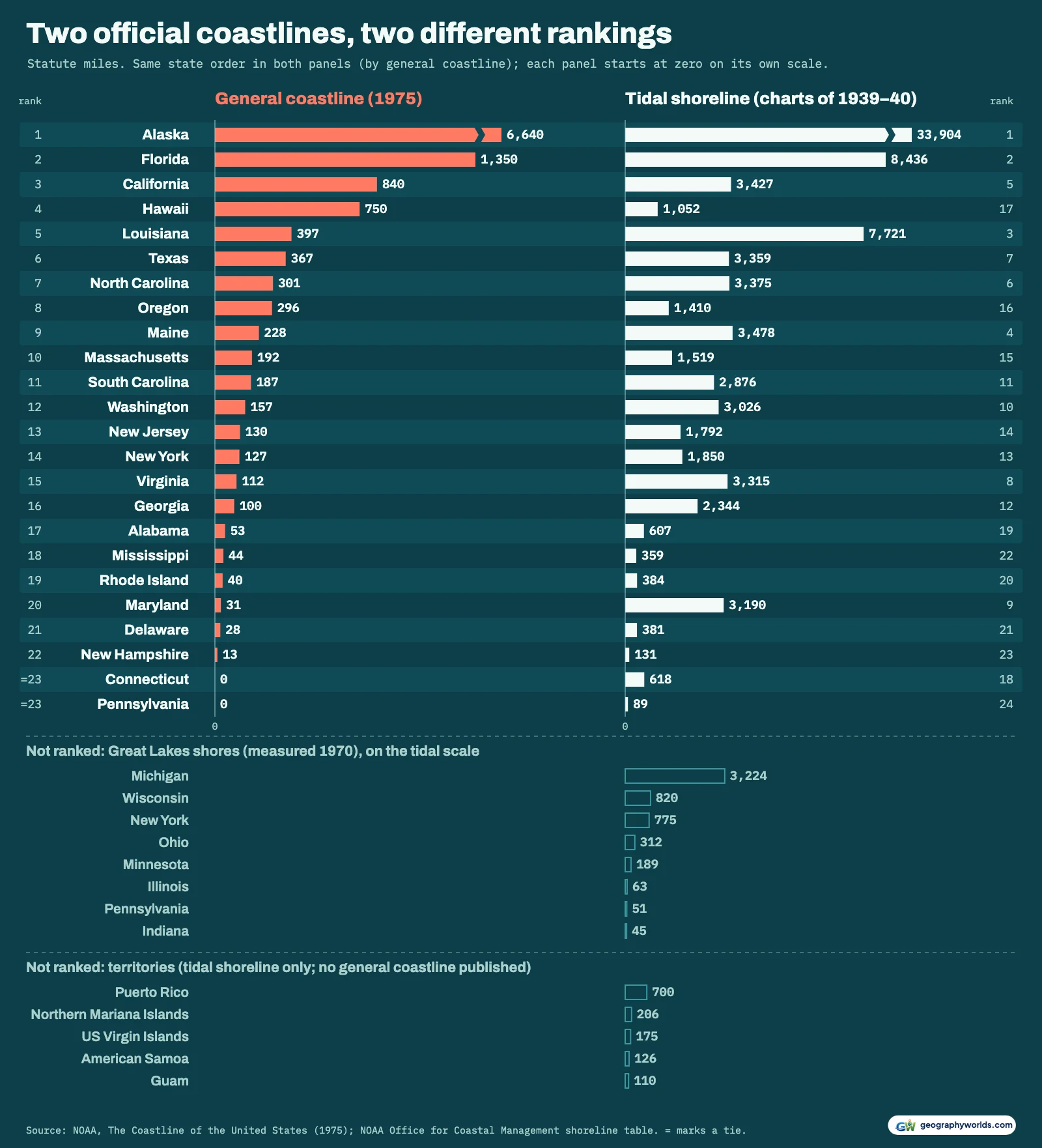
Louisiana's tidal shoreline is 19.4 times its general coastline; Maine's is 15.3 times. Hawaii moves the other way: fourth on the outline, it is only 17th on the tide, with 1,052 miles. Among states with any open coast, the gap is widest in Maryland, where 31 miles of open coast on the Atlantic sit beside 3,190 miles of Chesapeake shoreline, about 103 times as much.
| Rank | State | General coastline (mi) | Tidal shoreline (mi) | Tidal rank | 2021 tabulation (mi) |
|---|---|---|---|---|---|
| 1 | Alaska | 6,640 | 33,904 | 1 | 76,231 |
| 2 | Florida | 1,350 | 8,436 | 2 | 22,447 |
| 3 | California | 840 | 3,427 | 5 | 6,094 |
| 4 | Hawaii | 750 | 1,052 | 17 | 1,373 |
| 5 | Louisiana | 397 | 7,721 | 3 | 30,916 |
| 6 | Texas | 367 | 3,359 | 7 | 7,207 |
| 7 | North Carolina | 301 | 3,375 | 6 | 7,548 |
| 8 | Oregon | 296 | 1,410 | 16 | 2,734 |
| 9 | Maine | 228 | 3,478 | 4 | 5,000 |
| 10 | Massachusetts | 192 | 1,519 | 15 | 2,510 |
| 11 | South Carolina | 187 | 2,876 | 11 | 7,009 |
| 12 | Washington | 157 | 3,026 | 10 | 5,165 |
| 13 | New Jersey | 130 | 1,792 | 14 | 4,759 |
| 14 | New York | 127 | 1,850 | 13 | 3,112 |
| 15 | Virginia | 112 | 3,315 | 8 | 8,016 |
| 16 | Georgia | 100 | 2,344 | 12 | 5,107 |
| 17 | Alabama | 53 | 607 | 19 | 1,358 |
| 18 | Mississippi | 44 | 359 | 22 | 1,281 |
| 19 | Rhode Island | 40 | 384 | 20 | 616 |
| 20 | Maryland | 31 | 3,190 | 9 | 7,149 |
| 21 | Delaware | 28 | 381 | 21 | 1,232 |
| 22 | New Hampshire | 13 | 131 | 23 | 247 |
| =23 | Connecticut | 0 | 618 | 18 | 1,105 |
| =23 | Pennsylvania | 0 | 89 | 24 | 202 |
The coastline paradox, with real numbers
There is no single true length for a coast: the finer the map, the more bends it shows and the longer the line. The tidal figures make the point themselves. According to Maryland's Department of Natural Resources, NOAA's tidal mileage was measured by hand in 1939–40 on the largest-scale charts of the day and reconfirmed in 1961. When the Maryland Geological Survey traced the state's shore again from air photos at 1:12,000 rather than 1:20,000, it found 7,719 miles instead of 3,190.
To show the same effect on one state from one method, we measured Maine's sea edge on the Census Bureau's state outlines at three scales, leaving out the borders with New Hampshire and Canada. At 1:20,000,000 it comes to 374 miles. At 1:5,000,000 it is 705. At 1:500,000, where the islands appear, it is 1,512, 4.0 times the first figure. NOAA's own numbers bracket ours: 228 miles of general coastline, 3,478 of tidal shoreline, and 5,000 in a 2021 tabulation.
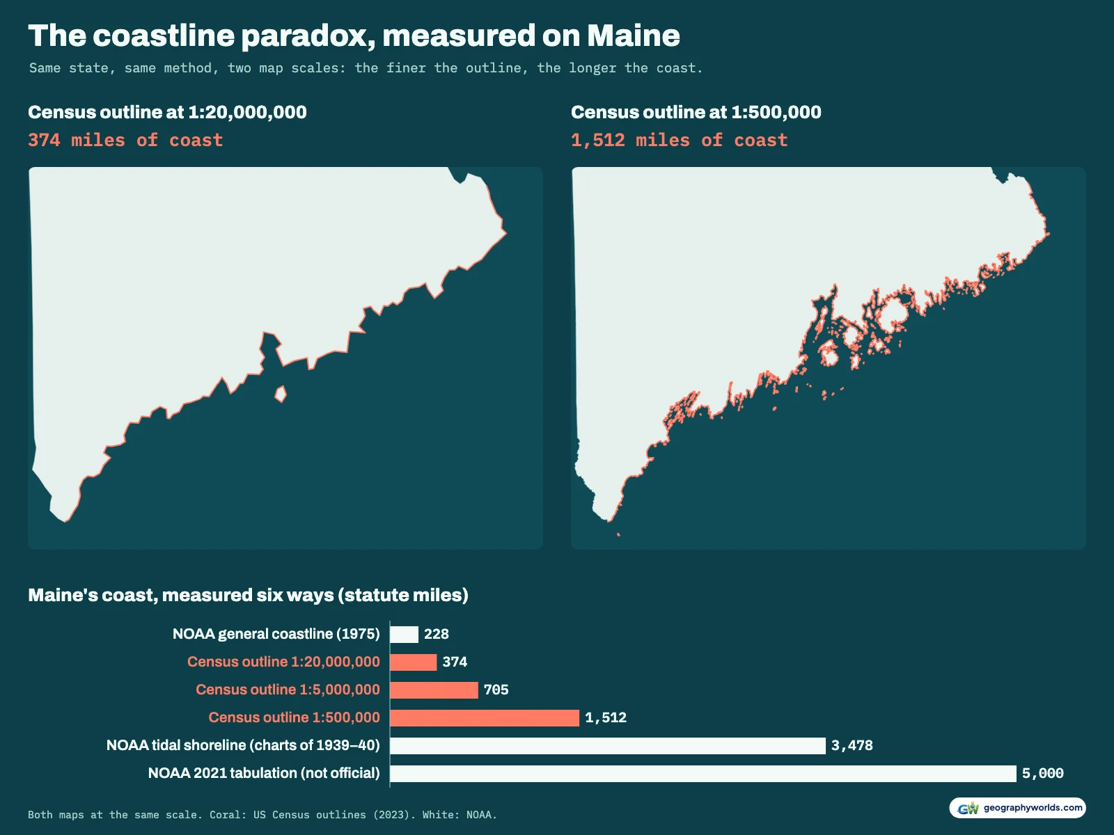
That 2021 tabulation is the third NOAA measure, and the finest. Published on NOAA's shoreline website, it uses the Continually Updated Shoreline Product simplified to a 1:24,000 scale, keeping streams at least 12 meters wide, and adds up to 221,923 miles for the United States and its territories. NOAA says plainly that it is not considered official. It changes second place: Louisiana, with 30,916 miles (49,754 km), comes out 38% ahead of Florida's 22,447. Alaska, at 76,231 miles, is still far in front.
On the 1:20,000,000 outlines our measured order of the top five, Alaska, Florida, California, Hawaii and Louisiana, is exactly NOAA's general-coastline order, and Alaska's 11,152 miles exceed the other 23 states' 8,726. At 1:500,000 the order shifts toward the tidal list: Florida stays second, but Washington rises to third, North Carolina to fourth and Maine to fifth, while California drops to sixth.
Alaska: three seas and two coasts
Alaska's general coastline splits into 5,580 miles on the Pacific side (NOAA's table has no separate Bering Sea row) and 1,060 miles on the Arctic Ocean. Its tidal shoreline is 31,383 Pacific miles and 2,521 Arctic miles. The State of Alaska quotes the same two totals and a third, larger one, 47,300 miles of estimated tidal shoreline. That is the number the US Army Corps of Engineers' 1971 National Shoreline Study gives for Alaska, printed beside NOAA's columns in the 1980 review.

Fjords like Aialik Bay show why: an outline steps across their mouths, while the tidal line runs in along one wall and out along the other. For the mountains and ice fields behind that coast, see our guide to Alaska's geography.
The Pacific states and Hawaii
California has 840 miles (1,352 km) of general coastline, third in the country, and 3,427 miles of tidal shoreline, fifth. Oregon has 296 and 1,410 miles. Washington is the Pacific's answer to Maryland: only 157 miles of general coastline, 12th, but 3,026 miles of tidal shoreline, tenth, because the outline stops at the narrow mouths of inland waters such as Puget Sound.
Hawaii's 750 miles (1,207 km) of general coastline put it fourth. The State of Hawaii Data Book gives the same 750 and 1,052 and splits them by county. NOAA's 2021 table gives the state 1,373 miles, listing a further 29 miles for the small Northwestern Hawaiian Islands separately.
The Gulf coast, from Texas to Florida
On the Gulf, Louisiana is where the measure matters. Its general coastline, 397 miles, ranks fifth. Its tidal shoreline, 7,721 miles (12,426 km), ranks third, and the 2021 tabulation, at 30,916, is 4.0 times the 1975 tidal figure, the largest jump of any state. The Mississippi delta and the marshes either side of it are laced with bayous, lakes and channels, and the finer the map, the more of them a measured line has to follow; our piece on Louisiana's bayous explains how that maze formed.

Texas has 367 miles of general coastline, sixth, and 3,359 miles of tidal shoreline, seventh. Mississippi (44 and 359 miles) and Alabama (53 and 607) have the shortest Gulf coasts. Florida counts on both seas. Its 1,350 miles of general coastline are 770 on the Gulf and 580 on the Atlantic; of its 8,436 tidal miles, 5,095 face the Gulf and 3,341 the Atlantic. The 1975 reprint has 3,331 and 8,426, the only state whose ocean figure differs between the two NOAA tables (New York's and Pennsylvania's OCM rows also include Great Lakes shore). Florida's environmental department rounds it to "the state's 8,400 miles of coastline" on its own site.
The Atlantic, from Georgia to Maine
North of Florida, North Carolina has the longest Atlantic coast on the outline measure, 301 miles, seventh overall, and 3,375 miles of tidal shoreline, sixth. Virginia has only 112 miles of general coastline but 3,315 tidal miles, eighth, and Maryland's 3,190 tidal miles rank ninth. South Carolina (187 and 2,876) and Georgia (100 and 2,344) each have more than ten times as much tidal shoreline as open coast.
Farther north, New Jersey has 130 and 1,792 miles, New York 127 and 1,850 on its ocean side, Massachusetts 192 and 1,519, Rhode Island 40 and 384, Delaware 28 and 381, and New Hampshire, with the shortest general coastline of any state that has one, 13 and 131. Two states have tidal shoreline but no general coastline at all: Connecticut, whose 618 miles all face Long Island Sound, and Pennsylvania, whose 89 miles run along the tidal Delaware River. Maine, at the northern end, climbs from ninth on the outline to fourth on the tide.
The Great Lakes, kept apart
The 1975 general coastline covers only the ocean, so the Great Lakes are not in it. NOAA's shoreline table does include them, measured in 1970 by the International Coordinating Committee on Great Lakes Basic Hydraulic and Hydrologic Data, and folds them into the state rows: New York's 2,625 miles there are 1,850 on the ocean side and 775 on the lakes, and Pennsylvania's 140 are 89 and 51. We keep all of them out of the ocean ranking.
Michigan has by far the most, 3,224 miles in NOAA's table; that would put it ninth on the tidal list if lake shores counted. Michigan's environment department gives a slightly higher 3,288 miles, 1,056 of them on islands. The 2021 tabulation gives 6,295.
Territories, and the numbers behind this page
The 1975 general coastline was published for states only. NOAA's tidal table adds Puerto Rico (700 miles), the Northern Mariana Islands (206), the US Virgin Islands (175), American Samoa (126) and Guam (110). With them and the Great Lakes, its national total is 95,439 miles. One warning if you use the 1980 reprint: its United States line, 13,443 and 91,154 miles, counts Alaska's Arctic coast twice, so we added up the states instead.
Our measurements count every edge of a Census Bureau state outline (2023) that no other state shares and that lies over 6 km from the Canadian or Mexican land border. You can download the data as a CSV with every state's general coastline, tidal shoreline, Great Lakes shore, 2021 figure and our three measurements; if you would rather see the map scales against each other as a chart than as a table, Parity will plot the columns you choose. Sources:
- NOAA, The Coastline of the United States (1975), Table 1 as reprinted in Statistical Review of the U.S. Coastal Zone (1980, for NOAA's Office of Coastal Zone Management): general coastline and tidal shoreline by state, statute miles; US government work, public domain (GPO govinfo)
- NOAA Office for Coastal Management, Shoreline Mileage of the United States: tidal shoreline by state and territory, Great Lakes shores measured in 1970; US government work, public domain
- NOAA Shoreline website, Shoreline Mileage: the 2021 tabulation (CUSP): a finer measurement that NOAA says is not official; public domain
- US Census Bureau, cartographic boundary files, states, 2023 (1:20,000,000, 1:5,000,000 and 1:500,000): state outlines measured for this article and drawn on the map; public domain
- Natural Earth 1:10m country boundaries (via world-atlas): US–Canada and US–Mexico land boundary, to keep borders out of the measured coast; public domain
- Maryland Department of Natural Resources, Maryland's Shoreline Length (January 2013)
For how the same question plays out between nations, compare this list with our ranking of the countries with the longest coastlines.