
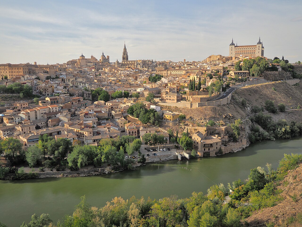
The Tagus (Tejo in Portuguese, Tajo in Spanish) is the longest river in the Iberian Peninsula at approximately 1,007 kilometers, flowing from its source in the Sierra de Albarracín in eastern Spain westward through Toledo and across Portugal to the Atlantic Ocean at Lisbon. It is the most important shared river between Spain and Portugal.
Introduction
Lisbon, Portugal's capital, was built on the Tagus's magnificent natural harbor, where the river widens into a broad estuary before meeting the Atlantic. The Tagus has been central to Iberian history, from Roman bridges to Moorish fortifications to the Age of Exploration, when Portuguese navigators sailed from its banks to chart the world's oceans.

Source to Sea
- Length: ~1,007 km (731 km in Spain, 276 km in Portugal)
- Source: Fuente de García, Sierra de Albarracín, Teruel, Spain (~1,593 m elevation)
- Mouth: Atlantic Ocean, at Lisbon, Portugal
The Tagus rises in the mountains of eastern Spain and flows westward across the Iberian Meseta, passing through Toledo, one of Spain's most historic cities. It enters Portugal at Vila Velha de Ródão, passing through dramatic gorges before broadening into a wide, navigable river through central Portugal. At Lisbon, the Tagus opens into a vast estuary called the Mar da Palha (Sea of Straw).
The Tagus Estuary at Lisbon is one of the largest in Europe, covering approximately 320 square kilometers. The estuary provided a perfect natural harbor for Lisbon, sheltering the Portuguese fleet and serving as the departure point for Vasco da Gama, Magellan, and countless other explorers during the Age of Discovery.
Geography & Course
- Basin Area: ~80,600 km² (69% in Spain, 31% in Portugal)
- Major Tributaries: Jarama, Guadiela, Alberche (Spain); Zezere, Sorraia (Portugal)
- Dam Count: Over 60 dams in the Spanish portion alone
The Tagus Basin extends across the central Iberian Meseta, a high interior plateau that gives the river a relatively arid catchment. Two-thirds of the basin lies in Spain, where the river has been heavily dammed for irrigation, hydroelectric power, and inter-basin water transfers. The Tagus-Segura water transfer, one of the most controversial water projects in Europe, diverts water from the Tagus to southeastern Spain.
In Portugal, the Tagus flows through a wider, lower valley with more Mediterranean vegetation. The riverside town of Santarém, on a bluff above the Tagus, is known as the "capital of Portuguese Gothic" for its medieval churches. The Almourol Castle, built on a tiny island in the Tagus, is one of Portugal's most romantic landmarks.
Climate & Hydrology
- Average Discharge: ~500 m³/s at mouth (historically; declining)
- Flow Reduction: Spanish dams and transfers have significantly reduced flow to Portugal
- Water Conflict: Spain-Portugal tensions over Tagus water allocation
The Tagus has a Mediterranean flow regime, with high winter and spring flows and very low summer flows. Spanish dam construction and inter-basin water transfers have significantly reduced the water reaching Portugal, creating diplomatic tensions. The Albufeira Convention (1998) established minimum flows at the Spanish-Portuguese border, but compliance is frequently disputed.
Climate change is exacerbating water scarcity in the Tagus Basin. Decreasing rainfall and increasing evaporation are reducing river flows across the Iberian Peninsula. Some climate projections suggest the Tagus could see flow reductions of 30 to 40 percent by mid-century, with severe consequences for both countries.
Ecology & Wildlife
- Tagus Estuary: One of Europe's most important wetlands for waterbirds
- Bird Species: Over 200,000 waterbirds winter in the estuary
- Fish: Native species declining due to dams and pollution
The Tagus Estuary is one of the most important wetlands in Europe for waterbirds, hosting over 200,000 wintering birds including flamingos, avocets, black-tailed godwits, and dunlins. The estuary's mudflats and salt marshes provide critical feeding and roosting habitat along the East Atlantic Flyway, which connects Arctic breeding grounds with African wintering areas.
The river's ecological health has declined significantly due to dam construction, agricultural pollution, and urban sewage, particularly in the Spanish section. The Tagus through Toledo and in parts of central Spain has suffered from severe water-quality problems, including algal blooms and fish kills. Conservation efforts focus on improving wastewater treatment and ensuring minimum ecological flows.
Human Geography & History
- Population in Basin: ~10 million people
- Historical Cities: Toledo, Lisbon, Santarém, Aranjuez
- Age of Exploration: Portuguese navigators departed from the Tagus at Lisbon
The Tagus has shaped Iberian history for millennia. Toledo, perched on a gorge above the Tagus in central Spain, was the capital of Visigothic Spain and later a center of the Reconquista. The Romans built the magnificent Alcantara Bridge over the Tagus in 106 CE, still standing after nearly 2,000 years and one of the greatest Roman engineering achievements.
Lisbon's position at the Tagus mouth made it the natural capital for Portugal's maritime empire. From the waterfront at Belém, Vasco da Gama departed in 1497 to find the sea route to India, and Magellan's fleet sailed in 1519 to circumnavigate the globe. The Tower of Belém and the Jeronimos Monastery, both UNESCO World Heritage Sites, stand on the Tagus banks as monuments to this era.
Key Facts
- The Tagus is the longest river in the Iberian Peninsula at approximately 1,007 km.
- The Tagus Estuary at Lisbon is one of Europe's largest and most important for waterbirds.
- Spanish dams and inter-basin transfers have significantly reduced water reaching Portugal.
- The Roman bridge at Alcantara, built in 106 CE, still spans the Tagus after nearly 2,000 years.
- Portuguese explorers departed from the Tagus at Lisbon to chart the world's oceans.
Fun Facts
- The Tagus-Segura water transfer diverts Tagus water 292 km to southeastern Spain via canals and tunnels.
- Lisbon's 25 de Abril Bridge over the Tagus looks nearly identical to the Golden Gate Bridge in San Francisco.
- The Mar da Palha (Sea of Straw) estuary at Lisbon covers 320 km², among Europe's largest.
- Toledo's El Greco painted the Tagus gorge in his famous "View of Toledo," one of art's first pure landscapes.
Final Thoughts
The Tagus is the thread that stitches the Iberian Peninsula together, connecting the dry interior of Spain to the Atlantic coast of Portugal. Its waters launched an age of global exploration and sustain critical ecosystems today. Managing the Tagus fairly between two nations in a warming, drying climate is one of Iberia's most pressing challenges.
Test Your Knowledge!
Think you know the world's rivers? Test your knowledge!
Play Geography Games →