
Tsunamis — from the Japanese "tsu" (harbor) and "nami" (wave) — are among the deadliest natural hazards on Earth. Unlike wind-driven ocean waves, tsunamis are generated by the sudden displacement of enormous volumes of water, typically by undersea earthquakes, volcanic eruptions, or submarine landslides. In the open ocean, tsunami waves travel at speeds up to 800 km/h with wave heights of less than a meter, making them nearly undetectable. But as they approach shallow coastal waters, they slow down, compress, and can build into walls of water exceeding 30 meters.
Introduction
The Pacific Ocean basin is the most tsunami-prone body of water on Earth, accounting for about 80 percent of all recorded tsunamis. The Ring of Fire subduction zones that rim the Pacific generate the megathrust earthquakes capable of displacing enough water to create transoceanic tsunamis. However, the catastrophic 2004 Indian Ocean tsunami proved that devastating tsunamis can originate in any ocean basin with active tectonic boundaries.

How Tsunamis Form
- Primary Cause: Submarine earthquakes (>7.0 magnitude) with vertical fault displacement
- Speed: Up to 800 km/h in deep ocean
- Wavelength: 100-200 km between crests in open ocean
- Run-up Height: Can exceed 30 m on land
Tsunamis require the sudden vertical displacement of a large area of ocean floor. This occurs most commonly during megathrust earthquakes at subduction zones, where the overriding plate snaps upward after being dragged down by the subducting plate. The 2011 Tohoku earthquake displaced the seafloor by up to 10 meters along a fault rupture 500 km long, displacing billions of cubic meters of water.
In the deep ocean, tsunami waves have extraordinarily long wavelengths (100-200 km) and small amplitudes (less than 1 meter), passing beneath ships undetected. But as the wave enters shallow coastal waters, the front slows while the back continues at high speed, causing the wave to compress and grow. This process, called shoaling, can amplify a 50-centimeter deep-ocean wave into a 10-meter-high wave at the coast.
Pacific Tsunami Zones
- Most Active Source: Chile-Peru subduction zone, Cascadia, Japan Trench, Aleutians
- Affected Coastlines: All Pacific Rim nations
- Historical Record: Over 1,000 tsunamis recorded in Pacific since 1900
- Warning System: Pacific Tsunami Warning Center (est. 1949, Hawaii)
The Pacific Ocean is ringed by subduction zones capable of generating transoceanic tsunamis. Chile's coastline has produced some of the most devastating: the 1960 Chilean earthquake generated a tsunami that crossed the Pacific in 15 hours, killing 61 people in Hawaii and 199 in Japan. The 1946 Aleutian Islands earthquake sent a tsunami that killed 159 in Hawaii, prompting the creation of the Pacific Tsunami Warning Center.
Japan has the most extensive tsunami historical record of any nation, with over 1,000 years of documented events. The word "tsunami" itself is Japanese, reflecting the country's long experience with these waves. The 2011 Tohoku tsunami reached run-up heights of 40.5 meters in Iwate Prefecture and penetrated up to 10 km inland, killing nearly 20,000 people despite Japan's advanced warning system and coastal defenses.
The 2004 Indian Ocean Tsunami
- Earthquake: Magnitude 9.1 off Sumatra, Indonesia
- Death Toll: ~227,898 across 14 countries
- Wave Heights: Up to 30 m in Banda Aceh
- Warning: No Indian Ocean tsunami warning system existed
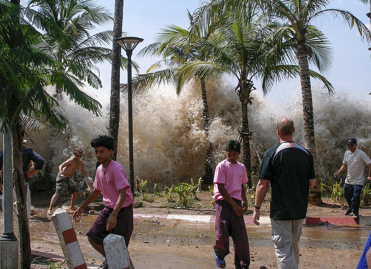
On December 26, 2004, a magnitude 9.1 earthquake off the west coast of Sumatra generated the deadliest tsunami in recorded history. Waves up to 30 meters high struck the coast of Banda Aceh, Indonesia, within minutes, then radiated across the Indian Ocean to strike Sri Lanka, India, Thailand, and eventually the east coast of Africa — over 7,000 km away. The death toll exceeded 227,000 across 14 countries.
The catastrophe was magnified by the complete absence of a tsunami warning system in the Indian Ocean. While the Pacific Tsunami Warning Center detected the earthquake within minutes, there was no mechanism to alert Indian Ocean nations. Beach-goers in Thailand actually walked toward the receding ocean — a classic tsunami precursor — unaware of the danger. The disaster led to the rapid creation of the Indian Ocean Tsunami Warning System, operational since 2006.
Tsunami Warning and Defense
- DART Buoys: Deep-ocean Assessment and Reporting of Tsunamis
- Warning Time: Minutes for local, hours for distant tsunamis
- Natural Indicators: Receding ocean, ground shaking, loud roaring sound
- Coastal Defenses: Seawalls, breakwaters, evacuation towers (Japan)
Modern tsunami warning systems rely on seismometers to detect triggering earthquakes and DART (Deep-ocean Assessment and Reporting of Tsunamis) buoys to confirm tsunami generation and measure wave height in the open ocean. The Pacific Tsunami Warning Center in Hawaii can issue basin-wide warnings within minutes of a major earthquake, giving distant coastlines hours of advance notice.
Japan has invested billions in tsunami defenses, including massive seawalls up to 15 meters high, breakwaters, and coastal evacuation towers. However, the 2011 Tohoku tsunami overtopped many of these defenses, leading to a reassessment of design standards. The most effective defense remains public education and rapid evacuation — communities in Japan that practiced regular tsunami drills experienced significantly lower casualty rates in 2011.
Emerging Tsunami Threats
- Cascadia Subduction Zone: Pacific Northwest US/Canada — overdue for magnitude 9+
- Mediterranean: Active faults near dense coastal populations
- Atlantic: Canary Islands volcanic landslide scenario
- Caribbean: Puerto Rico Trench subduction zone
The Cascadia Subduction Zone off the Pacific Northwest coast of the US and Canada last ruptured in a magnitude 9+ earthquake on January 26, 1700. Geological evidence shows these great earthquakes recur roughly every 200-500 years, meaning the zone is within its recurrence window. A Cascadia megathrust earthquake would generate a tsunami striking the coasts of Washington, Oregon, and British Columbia within 15-30 minutes — far less warning time than a transoceanic event.
The Mediterranean Sea, surrounded by active tectonic boundaries, has produced significant historical tsunamis. The 365 AD Crete earthquake generated a tsunami that devastated Alexandria, Egypt. The densely populated Mediterranean coastline — home to major cities like Nice, Barcelona, and Athens — faces tsunami risk from faults in the Hellenic Arc, the Calabrian Arc, and offshore Algeria.
Key Facts
- About 80% of all recorded tsunamis occur in the Pacific Ocean basin.
- The 2004 Indian Ocean tsunami killed ~228,000 people across 14 countries.
- Tsunami waves can travel at up to 800 km/h in deep ocean — as fast as a jet aircraft.
- The 2011 Tohoku tsunami reached a maximum run-up height of 40.5 meters.
- The Cascadia Subduction Zone is considered overdue for a magnitude 9+ earthquake and tsunami.
Fun Facts
- The Japanese town of Aneyoshi has a centuries-old stone tablet reading "Do not build your homes below this point!" — placed above the reach of historical tsunamis.
- The 1958 Lituya Bay, Alaska tsunami produced the tallest wave ever recorded — 524 meters — caused by a landslide, not an earthquake.
- Tsunami waves can cross the entire Pacific Ocean in less than 24 hours.
- Ancient oral traditions of indigenous peoples in the Pacific Northwest describe great floods now confirmed to be the 1700 Cascadia tsunami.
Final Thoughts
Tsunami zones are defined by the tectonic boundaries that generate the earthquakes, eruptions, and landslides that displace ocean water. While the Pacific Ring of Fire remains the most prolific source, the 2004 Indian Ocean catastrophe proved that tsunami preparedness must be global. Advances in detection, warning systems, and public education have saved thousands of lives, but the threat of a major tsunami striking an unprepared coastline remains one of the most serious natural hazards facing humanity.
Test Your Knowledge!
Think you know the world's extreme weather?
Play Geography Games →