
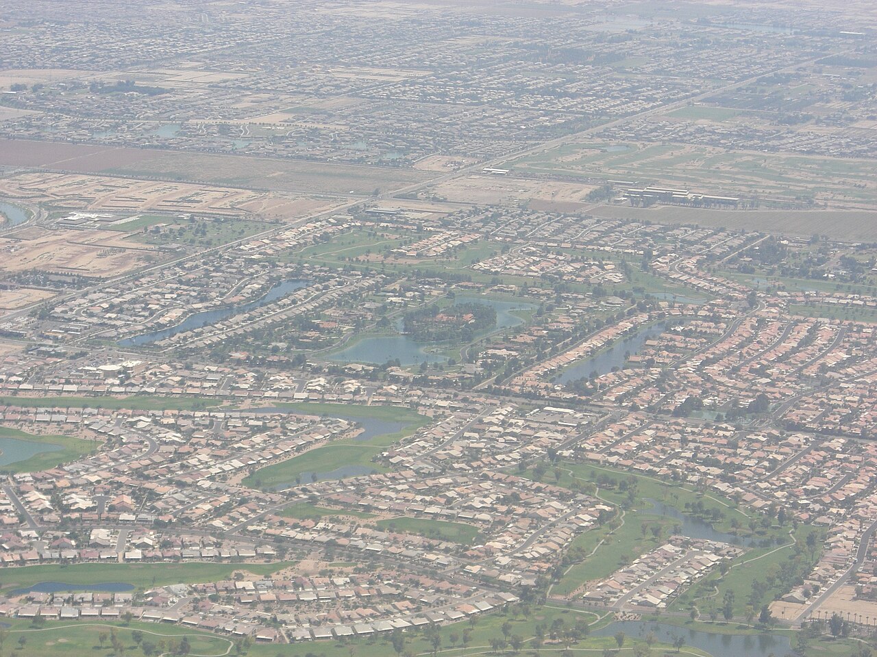
Urban sprawl is the uncontrolled, low-density expansion of cities and suburbs into surrounding rural areas, characterized by car-dependent development, separated land uses, and large amounts of open space consumed by scattered development. Sprawl is one of the most significant geographic transformations of the modern era — globally, urban areas have expanded at twice the rate of population growth since 1945.
Introduction
The consequences of sprawl are profound: longer commutes, higher infrastructure costs, loss of farmland and natural habitat, increased greenhouse gas emissions, and social isolation. Yet sprawl also reflects genuine human preferences for space, privacy, and homeownership. Understanding urban sprawl requires examining the geographic, economic, and policy forces that shape how cities grow.
What Causes Urban Sprawl
- Cheap Land: Rural land on city edges is much cheaper than urban core land
- Car Dependence: Highways enable people to live far from work
- Zoning Laws: Single-use zoning separates housing, shopping, and employment
- Housing Preferences: Many people prefer single-family homes with yards
- Lack of Planning: Weak regional planning allows uncoordinated development
- Subsidies: Government subsidies for highways, mortgage interest, and utilities encourage low-density development
In the United States, the federal government heavily subsidized sprawl through highway construction (the Interstate system), mortgage interest tax deductions that favored homeownership in suburbs, and utility pricing that did not reflect the true cost of extending infrastructure to low-density areas. The result was an explosion of suburban development from the 1950s onward.
In developing countries, a different kind of sprawl occurs. Cities like Lagos, Dhaka, and Cairo grow outward through informal settlements as rural migrants seek economic opportunities. This "informal sprawl" happens without planning, infrastructure, or services, creating vast peripheral areas without adequate water, sewage, or transportation.
Effects of Urban Sprawl
- Environment: Loss of farmland, habitat fragmentation, increased emissions
- Transportation: Average American commutes 55 minutes/day; car dependency
- Cost: Sprawl costs US cities $1 trillion/year in extra infrastructure
- Health: Obesity rates higher in sprawling areas; less walking and cycling
- Social: Isolation, fewer community interactions, car-dependent elderly
- Agriculture: US loses about 2,000 acres of farmland per day to development
The environmental costs of sprawl are substantial. When a city spreads across the landscape, it paves over farmland, forests, and wetlands, fragmenting wildlife habitats and increasing impervious surfaces that cause flooding. Per-capita greenhouse gas emissions are typically 2-3 times higher in sprawling suburbs than in compact urban neighborhoods, primarily due to car travel.
The economic costs are often hidden. Extending roads, water pipes, sewer lines, and electric grid to scattered low-density development costs far more per household than serving compact neighborhoods. A study by the London School of Economics estimated that sprawl costs US cities over $1 trillion per year in additional infrastructure and transportation expenses.
Examples Around the World
- Houston, USA: No zoning laws; extreme car dependency; 4,841 km² urban area
- Atlanta, USA: 7,296 km² metro area for only 6 million people
- Lagos, Nigeria: Informal sprawl; population grew from 1.4M (1970) to 15M+ today
- Phoenix, USA: Desert city sprawling across 1,340 km²; heavy water demands
- Cairo, Egypt: Expanding onto irreplaceable Nile Valley farmland
- Melbourne, Australia: Rapid outer suburban growth consuming bushland
Houston is often cited as the epitome of sprawl. It is the only major US city without zoning laws, meaning development is largely unregulated. The result is a vast, low-density metropolitan area where the average resident drives over 35 km per day and public transit carries less than 3% of commuters.
Lagos represents developing-world sprawl driven by rapid urbanization. The city adds hundreds of thousands of new residents each year, most settling in informal peripheral areas without basic services. The result is a metropolitan area of over 15 million people where traffic congestion is among the worst on Earth and many residents live without reliable water or electricity.
Solutions & Smart Growth
- Smart Growth: Compact, walkable, transit-oriented development
- Urban Growth Boundaries: Portland, Oregon limits outward expansion by law
- Mixed-Use Zoning: Allow housing, shops, and offices in the same areas
- Transit Investment: Rail and bus systems reduce car dependency
- Infill Development: Building on vacant or underused land within existing cities
- Copenhagen Model: Finger plan concentrates growth along transit corridors
Portland, Oregon pioneered the "urban growth boundary" in 1979, drawing a legal line around the metropolitan area beyond which development is prohibited. This has kept Portland significantly more compact than comparable US cities, preserved surrounding farmland, and supported one of the most successful light-rail systems in the country.
Copenhagen's "Finger Plan" of 1947 shaped the city's growth along five transit corridors radiating from the center, like the fingers of a hand. Between the fingers, green wedges of parkland and farmland were preserved. This plan has given Copenhagen a compact, transit-friendly form that makes it one of the most livable cities in the world.
Key Facts
- Urban areas have expanded at twice the rate of population growth since 1945.
- The US loses about 2,000 acres of farmland to development every day.
- Per-capita greenhouse gas emissions are 2-3 times higher in sprawling suburbs than compact cities.
- Sprawl costs US cities an estimated $1 trillion per year in extra infrastructure.
- Portland's urban growth boundary has kept the city significantly more compact than comparable metros.
Fun Facts
- If Los Angeles had the density of Paris, its entire metropolitan population could fit into an area just 10% of its current size.
- The phrase "urban sprawl" was first used in print in 1937 by the sociologist Earle Draper.
- Tokyo is denser than Los Angeles yet has lower average commute times, thanks to its extensive rail network.
- In 1950, only 30% of the world's population lived in cities; today it is 56%, and by 2050 it will be 68%.
Final Thoughts
Urban sprawl is one of the most consequential geographic phenomena of the modern era, reshaping landscapes, transportation patterns, and lifestyles worldwide. As cities continue to grow, the choice between sprawl and compact development will determine the environmental, economic, and social future of urban geography.
Test Your Knowledge!
Think you know your geography? Try our interactive quiz!
Play Geography Games →