
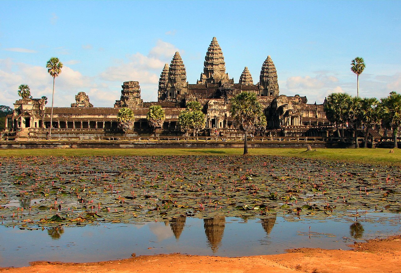
Angkor Wat is the world's largest religious monument — a 162.6-hectare temple complex in the jungles of northwestern Cambodia that represents the pinnacle of the Khmer Empire's extraordinary civilization.
Introduction
The Khmer Empire (802–1431 CE) was Southeast Asia's most powerful medieval state, controlling territory from modern Myanmar to Vietnam. At its heart was the city of Angkor, which at its peak in the 12th–13th centuries may have housed 750,000–1,000,000 people, making it the largest pre-industrial city on Earth.
What made Angkor possible was not military might but hydraulic engineering. The Khmer built an enormous water management system — reservoirs (barays), canals, and rice paddies — that turned seasonal monsoon floods into year-round irrigation, enabling multiple rice harvests per year in the tropical lowlands north of Tonle Sap lake.
Geography and Water Systems
- Tonle Sap: Southeast Asia's largest freshwater lake — expands from 2,500 km² to 16,000 km² during monsoon season
- West Baray: Largest Khmer reservoir: 8 km × 2.3 km, holding 56 million m³ of water
- Canal Network: Over 1,000 km of canals distributing water across the Angkor plain
Angkor sits on a flat plain between the Kulen Hills to the north and Tonle Sap lake to the south. The monsoon climate delivers 80% of annual rainfall between May and October, creating a feast-or-famine water cycle. The Khmer solution was monumental: they built vast rectangular reservoirs (barays) to store monsoon water and canal networks to distribute it during the dry season.
The West Baray alone could irrigate thousands of hectares of rice paddies year-round. This hydraulic system supported rice yields of 2–3 harvests per year, compared to the single harvest possible with rain-fed agriculture. The resulting food surplus sustained the massive population and labor force needed to build Angkor's temples.
Angkor Wat and Temple Architecture
- Angkor Wat: Built by Suryavarman II (c. 1113–1150 CE) — 162.6 hectares, moat 190 m wide, central tower 65 m tall
- Bayon: Built by Jayavarman VII — 216 serene stone faces carved into 54 towers
- Ta Prohm: Buddhist temple complex left partially unrestored — massive tree roots engulf stone walls
Angkor Wat was designed as a representation of Mount Meru, the cosmic mountain of Hindu mythology. Its five towers represent Meru's five peaks; the surrounding moat represents the cosmic ocean. The temple faces west (unusual for Hindu temples, which typically face east), possibly indicating its original function as a funerary temple.
The construction of Angkor Wat required an estimated 5–10 million sandstone blocks, quarried from Phnom Kulen (50 km away) and transported by canal and raft. The bas-reliefs along its outer gallery stretch for 800 m and depict Hindu epics, historical battles, and scenes of daily Khmer life with extraordinary detail.
Empire and Trade
- Peak Territory: Modern Cambodia, Thailand, Laos, southern Vietnam, and parts of Myanmar and Malaysia
- Population: 750,000–1,000,000 in greater Angkor at its 13th-century peak
- Trade: Chinese ceramics, Indian textiles, and regional spices flowed through Khmer ports
The Khmer Empire's power was based on rice production and control of regional trade routes. The Mekong River and Tonle Sap provided natural highways connecting the empire to the South China Sea and Chinese maritime trade. Khmer ports traded rice, aromatic woods, animal hides, and forest products for Chinese ceramics and Indian luxury goods.
A 13th-century Chinese diplomat, Zhou Daguan, left a detailed account of Angkor describing golden towers, elaborate ceremonies, and a sophisticated multi-ethnic society. His writings remain one of the most important primary sources for understanding daily life in the Khmer Empire.
Decline and Rediscovery
Angkor was gradually abandoned in the 15th century, with the Khmer capital shifting to Phnom Penh. Researchers now believe the hydraulic system that sustained Angkor ultimately failed due to a combination of factors: mega-droughts (confirmed by tree-ring data), over-engineering that made the water system fragile, and the erosion of canals caused by deforestation.
The jungle reclaimed most of Angkor's 1,000+ temples over the following centuries. French naturalist Henri Mouhot famously "rediscovered" Angkor Wat in 1860, though local Cambodians had always known of its existence. Today, the Angkor Archaeological Park is Cambodia's top tourist destination and a UNESCO World Heritage Site, attracting over 2 million visitors annually.
Key Facts
- Angkor Wat is the world's largest religious monument at 162.6 hectares
- Greater Angkor may have held 750,000–1,000,000 people — the largest pre-industrial city on Earth
- The West Baray reservoir held 56 million cubic meters of water
- Over 1,000 temples survive in the Angkor Archaeological Park
- Tonle Sap expands from 2,500 km² to 16,000 km² between dry and wet seasons
Fun Facts
- Angkor Wat appears on Cambodia's national flag — the only building to appear on any national flag
- The temple complex is so vast that it was identified from NASA satellite imagery in the 1990s, revealing a previously unknown urban sprawl
- Angkor Wat's moat is home to a population of crocodiles that have lived there for centuries
- The Khmer Empire's decline coincided with the Medieval Climate Anomaly — mega-droughts in the 14th–15th centuries disrupted their water system
Final Thoughts
Angkor and the Khmer Empire demonstrate how hydraulic engineering can transform tropical lowlands into the foundation of a great civilization. The Khmer turned seasonal monsoon floods into year-round irrigation, supporting the largest pre-industrial city on Earth — but when the water system failed, the civilization fell with it.
Test Your Knowledge!
Think you know your ancient civilizations? Try our interactive geography quiz!
Play Geography Games →