
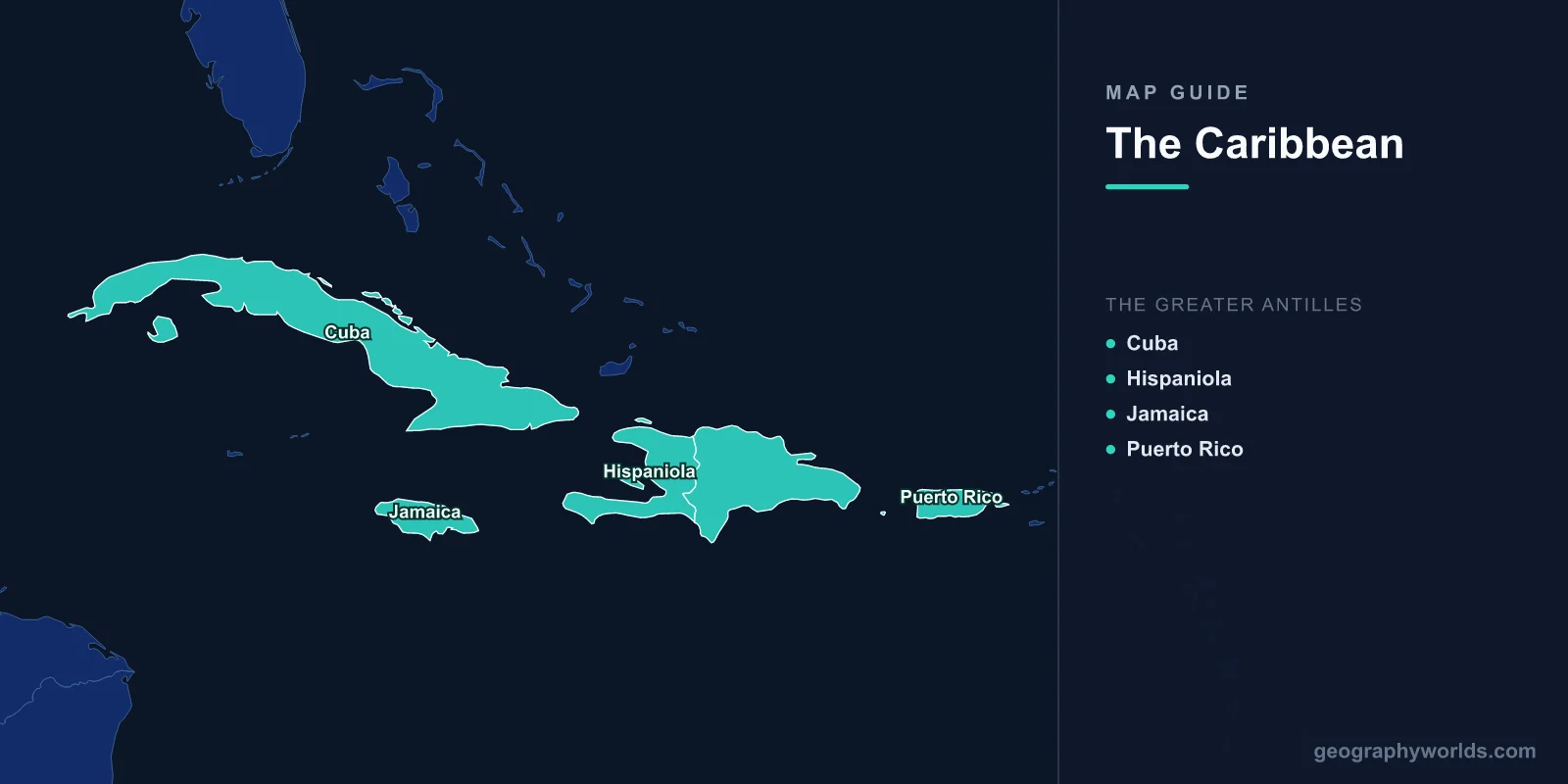
A map of the Caribbean shows a crescent-shaped archipelago of more than 7,000 islands, islets, reefs, and cays stretching 4,000 km from the Bahamas near Florida to Trinidad off the coast of Venezuela. The Caribbean Sea, covering 2.75 million km2, is bounded by Central America to the west, South America to the south, and the island chains to the north and east. The region contains 13 sovereign nations and numerous overseas territories, with a combined population of approximately 44 million people.
Geography of the Caribbean
The Caribbean region is defined by the Caribbean Sea, a body of the western Atlantic Ocean. The sea sits on the Caribbean Plate, which is bounded by subduction zones on its eastern and western margins. This tectonic activity has created the volcanic islands of the Lesser Antilles and the deep Cayman Trench (7,686 m—the deepest point in the Caribbean).
The islands are divided into three main groups: the Bahamas (which technically lie in the Atlantic rather than the Caribbean Sea), the Greater Antilles, and the Lesser Antilles. The region's geography ranges from low-lying coral atolls barely above sea level to volcanic peaks exceeding 3,000 m on Hispaniola.
The Caribbean Sea is generally 1,000–3,000 m deep, with warm surface temperatures (26–29°C year-round) that fuel the Atlantic hurricane season from June to November. Coral reefs—including the Mesoamerican Barrier Reef (the second-longest in the world at 1,000 km)—fringe many islands and provide critical marine habitat.

Greater Antilles
The Greater Antilles comprise the four largest Caribbean islands, containing over 90% of the region's land area:
- Cuba: 109,884 km2; largest Caribbean island; population 11.2 million; capital Havana. Mostly flat to rolling plains with the Sierra Maestra mountains (1,974 m) in the southeast.
- Hispaniola: 76,192 km2; shared by Haiti (27,750 km2, 11.6 million) and the Dominican Republic (48,671 km2, 11.1 million). Pico Duarte (3,098 m) is the Caribbean's highest peak. Dramatic terrain contrast between the lush Cibao Valley and the arid Azua basin.
- Jamaica: 10,991 km2; population 3 million; capital Kingston. Mountainous interior with Blue Mountain Peak (2,256 m). Known for its lush vegetation and over 120 rivers.
- Puerto Rico: 9,104 km2; population 3.2 million; US territory. Central mountain range (Cordillera Central) with El Yunque tropical rainforest. One of the most densely populated islands in the world.
Lesser Antilles
The Lesser Antilles form an arc of smaller islands from the Virgin Islands south to Trinidad and Tobago, divided into the Leeward and Windward Islands:
- Leeward Islands (north): US and British Virgin Islands, Anguilla, Saint Martin/Sint Maarten, Saint Kitts and Nevis, Antigua and Barbuda, Montserrat, Guadeloupe (France). Mix of volcanic and coral limestone islands.
- Windward Islands (south): Dominica, Martinique (France), Saint Lucia, Saint Vincent and the Grenadines, Grenada. Predominantly volcanic with lush rainforests, hot springs, and dramatic peaks. Dominica has 365 rivers and 9 active volcanoes.
- Southern Caribbean: Barbados (coral limestone island east of the main chain), Trinidad and Tobago (continental shelf islands off Venezuela), and the ABC Islands (Aruba, Bonaire, Curacao—Netherlands).
Countries & Territories
The Caribbean contains 13 sovereign nations:
- Antigua and Barbuda, The Bahamas, Barbados, Cuba, Dominica, Dominican Republic, Grenada, Haiti, Jamaica, Saint Kitts and Nevis, Saint Lucia, Saint Vincent and the Grenadines, Trinidad and Tobago.
Additionally, the region includes territories of the United States (Puerto Rico, US Virgin Islands), United Kingdom (Cayman Islands, Turks and Caicos, British Virgin Islands, Montserrat, Anguilla), France (Guadeloupe, Martinique, Saint Barthélemy, Saint Martin), and the Netherlands (Aruba, Bonaire, Curacao, Sint Maarten, Saba, Sint Eustatius).
Major Cities
- Havana: 2.1 million; Cuba's capital; largest city in the Caribbean; historic colonial architecture.
- Santo Domingo: 3.6 million (metro); capital of the Dominican Republic; oldest continuously inhabited European settlement in the Americas (founded 1496).
- San Juan: 2.3 million (metro); capital of Puerto Rico; major cruise ship port.
- Kingston: 1.2 million (metro); Jamaica's capital; natural harbor backed by the Blue Mountains.
- Port-au-Prince: 2.8 million (metro); capital of Haiti; situated on the Gulf of Gonave.
- Nassau: 275,000; capital of The Bahamas; on New Providence Island.
Climate
- Type: Tropical maritime; warm and humid year-round. Average temperatures 24–29°C.
- Hurricane season: June 1 to November 30; peak activity August–October. The Caribbean lies in the main development region for Atlantic hurricanes.
- Rainfall: Varies dramatically by island and aspect. Windward slopes may receive 3,000–5,000 mm annually; leeward sides as little as 500 mm. Dry season typically January–May.
- Trade winds: Northeast trade winds moderate temperatures and create distinct windward (wet) and leeward (dry) sides on mountainous islands.
Key Facts About the Caribbean Map
- The Caribbean contains over 7,000 islands, islets, reefs, and cays.
- Cuba (109,884 km2) is larger than all other Caribbean islands combined.
- Pico Duarte in the Dominican Republic (3,098 m) is the highest point in the Caribbean.
- The Cayman Trench reaches 7,686 m—the deepest point in the Caribbean Sea.
- The Caribbean has 13 sovereign nations and numerous overseas territories of four different countries.
- Haiti and the Dominican Republic share the island of Hispaniola—one of only two Caribbean islands divided between nations (the other is Saint Martin/Sint Maarten).
- Trinidad sits just 11 km from the Venezuelan coast and was once connected to South America.
Final Thoughts
The Caribbean map reveals a region of remarkable geographic diversity packed into a relatively compact ocean basin. From Cuba's sprawling plains to Dominica's volcanic peaks, from the Bahamas' low-lying coral cays to Hispaniola's mountain summits rivaling the Alps in height, the Caribbean islands showcase the full spectrum of tropical island geography. Understanding the distinction between the Greater and Lesser Antilles, the role of plate tectonics and volcanism, and the influence of trade winds and hurricanes is essential for anyone studying this dynamic region.
Test Your Geography Knowledge!
Think you know your maps? Try our interactive geography games!
Play Geography Games →