
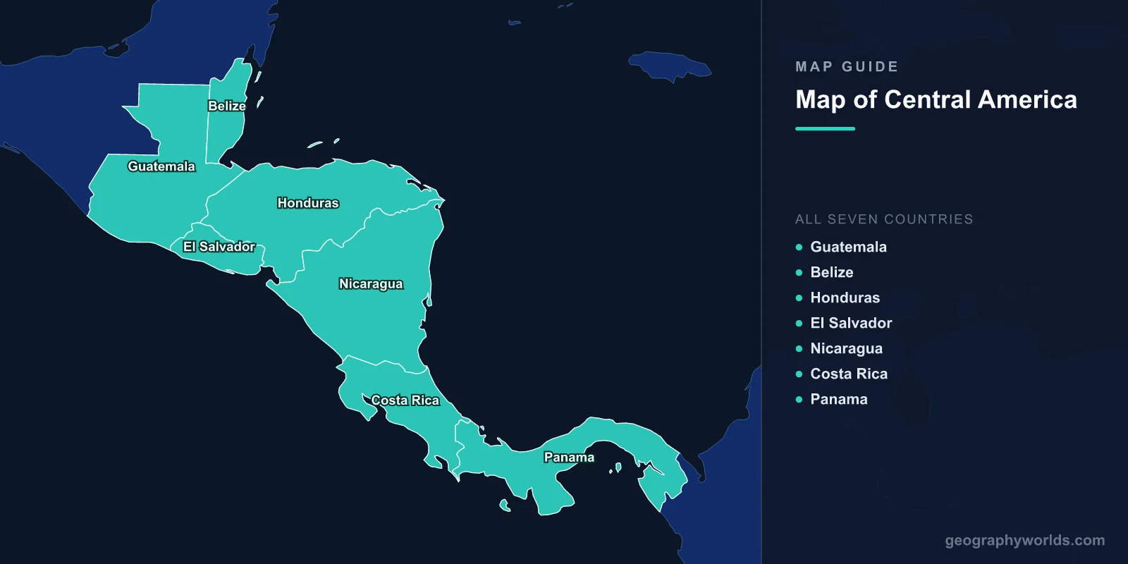
Central America is a narrow isthmus connecting North America to South America, covering approximately 522,760 km2 (201,838 sq mi) with a combined population of about 50 million across 7 countries. The region stretches roughly 1,800 km from Guatemala’s border with Mexico in the northwest to Panama’s border with Colombia in the southeast, narrowing to just 50 km at the Panama Canal.
Introduction
Central America is bordered by Mexico and the Caribbean Sea to the north and east, the Pacific Ocean to the south and west, and Colombia to the southeast. The region sits on the Caribbean Plate and is part of the Pacific Ring of Fire, resulting in frequent volcanic eruptions and earthquakes. A chain of over 100 volcanoes runs through the Pacific lowlands, and several remain highly active.

Geographic Overview
- Area: ~522,760 km2 (201,838 sq mi)
- Population: ~50 million (2024)
- Countries: 7 sovereign nations
- Highest Point: Volcán Tajumulco, 4,220 m (Guatemala)
- Major Waterway: Panama Canal (82 km)
- Climate: Tropical; wet and dry seasons
Central America’s terrain features a volcanic highland spine along the Pacific side and lower Caribbean lowlands covered in tropical rainforest. The volcanic chain includes over 100 volcanoes, with at least 14 considered currently active. The isthmus narrows dramatically in Panama, where the 82 km Panama Canal connects the Atlantic and Pacific oceans.
The 7 Countries
- Guatemala: Guatemala City; 108,889 km2; 18 million; Maya heritage; volcanoes
- Belize: Belmopan; 22,966 km2; 410,000; Mesoamerican Barrier Reef; English-speaking
- Honduras: Tegucigalpa; 112,492 km2; 10.3 million; Bay Islands; largest area
- El Salvador: San Salvador; 21,041 km2; 6.3 million; smallest; most densely populated
- Nicaragua: Managua; 130,373 km2; 7 million; largest Central American country; Lake Nicaragua
- Costa Rica: San José; 51,100 km2; 5.2 million; biodiversity hotspot; no military
- Panama: Panama City; 75,417 km2; 4.4 million; Panama Canal; banking hub
Each Central American country has distinct geographic character. Guatemala’s highlands contain the largest indigenous Maya population. Belize has the Western Hemisphere’s largest barrier reef. Nicaragua contains Central America’s two largest lakes. Costa Rica protects 25% of its territory in national parks. Panama controls one of the world’s most strategic waterways.
Major Geographic Features
- Volcán Tajumulco: 4,220 m; Central America’s highest peak; Guatemala
- Lake Nicaragua: 8,264 km2; largest lake in Central America; freshwater sharks
- Panama Canal: 82 km; connects Atlantic and Pacific; opened 1914
- Mesoamerican Barrier Reef: 1,000 km; second-longest reef; Belize coast
- Mosquito Coast: Caribbean lowland; Honduras/Nicaragua; tropical rainforest
- Laguna de Apoyo: Volcanic crater lake; Nicaragua; formed ~23,000 years ago
Central America’s volcanic geology has created fertile highland soils ideal for coffee cultivation—the region is a major global coffee producer. Lake Nicaragua is the only freshwater lake known to harbor bull sharks, which travel up the San Juan River from the Caribbean. The Darién Gap between Panama and Colombia remains one of the last unroaded sections of the Pan-American Highway.
Bodies of Water
- Caribbean Sea: Eastern coastline; coral reefs; island groups
- Pacific Ocean: Western coastline; volcanic beaches; surfing destinations
- Lake Nicaragua: 8,264 km2; Ometepe Island with twin volcanoes
- Lake Atitlán: 130 km2; volcanic caldera lake; Guatemala; 340 m deep
- Gatun Lake: 425 km2; artificial lake; part of the Panama Canal system
Central America’s dual coastlines give it access to both the Caribbean and Pacific, a key factor in trade and biodiversity. The Caribbean coast tends to be wetter, with tropical lowland rainforests, while the Pacific side has more pronounced dry seasons. Rivers in the region are short but powerful, fed by heavy tropical rainfall.
Climate & Biodiversity
- Climate: Tropical; temperatures 24–32°C; wet/dry seasons
- Biodiversity: 7–12% of world’s species in 0.5% of Earth’s land
- Cloud Forests: Highlands above 1,500 m; Monteverde (Costa Rica)
- Coral Reefs: Mesoamerican Reef; Caribbean coast
Despite covering only 0.5% of Earth’s land surface, Central America harbors an estimated 7–12% of the world’s biodiversity. Costa Rica alone has recorded over 500,000 species. The region serves as a land bridge that allowed species from North and South America to intermix during the Great American Interchange about 3 million years ago. Cloud forests in the highlands shelter quetzals, jaguars, and thousands of orchid species.
Key Facts
- Central America has 7 countries spanning 522,760 km2 of isthmus between the Americas.
- The Panama Canal handles about 5% of global maritime trade.
- Lake Nicaragua (8,264 km2) is Central America’s largest lake.
- Volcán Tajumulco (4,220 m) in Guatemala is the region’s highest point.
- Central America contains 7–12% of global biodiversity on 0.5% of Earth’s land.
Fun Facts
- Bull sharks in Lake Nicaragua travel 190 km up the San Juan River from the Caribbean.
- Costa Rica abolished its military in 1948 and redirected defense spending to education and healthcare.
- The Darién Gap is a 100 km stretch of roadless jungle separating Panama from Colombia.
- El Salvador is the only Central American country without a Caribbean coastline.
Final Thoughts
Central America’s map reveals a narrow but geographically dynamic isthmus shaped by volcanism, tropical climate, and its unique position as a land bridge between continents. Its 7 countries pack extraordinary biodiversity, volcanic landscapes, coral reefs, and the world’s most important interoceanic waterway into a compact geographic space.
Test Your Geography Knowledge!
Think you know your maps? Try our interactive geography games!
Play Geography Games →