

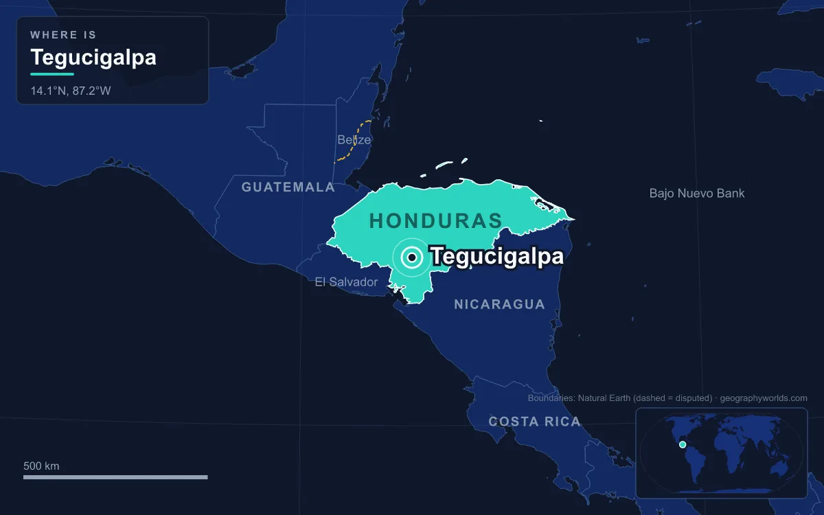
Tegucigalpa is the capital and largest city of Honduras, and formally it is not one city but two: Tegucigalpa and its sister city Comayagüela, facing each other across the Choluteca River, make up the Central District (Distrito Central) that the constitution names as the permanent national capital. The district lies in a mountain-ringed valley in the south-central highlands, at roughly 1,000 m above sea level, and had a projected 1,326,460 inhabitants in 2023. Tegucigalpa has held the title only since 30 October 1880, when President Marco Aurelio Soto moved the government from the old colonial capital of Comayagua, ending more than half a century in which the two cities had traded the role back and forth.
Comayagua Versus Tegucigalpa, 1537–1880
The colonial capital in the middle of two oceans
For most of Honduran history the capital was somewhere else. Captain Alonso de Cáceres founded Santa María de la Concepción de Comayagua in 1537, under orders to find a site for a city “in the middle of the two oceans”, and the result was a city in the centre of the country, in a flat valley about 80 km northwest of Tegucigalpa. Philip II granted it the title of city in 1557, the bishopric moved there from Trujillo on the Caribbean coast in 1561, and the cathedral that still stands on its central square was built between 1634 and 1715. Comayagua remained the capital of the province throughout the colonial period and was the first town in Honduras with a system of aqueducts and fountains.

A silver camp founded in 1578
Tegucigalpa began as a mining settlement. Spanish settlers founded Real de Minas de San Miguel de Tegucigalpa on 29 September 1578, on the site of an existing Lenca and Tolupan village, and Juan de la Cueva became its first mayor the next year. The name is often explained as Nahuatl for “hills of silver”, although that reading is disputed. As the silver mines prospered, the town began to challenge Comayagua from the mid-17th century. In 1762 it became the Real Villa de San Miguel de Tegucigalpa y Heredia, and its church of San Miguel Arcángel, built from 1765 to 1786 and consecrated in 1782, was the largest church in colonial Honduras.
Comayagua answered with administrative weight. When it became the seat of an intendancy in 1788, Tegucigalpa was absorbed as a sub-delegation, provoking a revolt, and in 1791 it was placed under Comayagua’s control outright. It regained its own government only in 1817. That year its mayor, Narciso Mallol, started a ten-arch masonry bridge across the Choluteca River, finished four years later, and in 1821 Tegucigalpa legally became a city. It was also the birthplace, in 1792, of Francisco Morazán, who would serve three times as president of the Federal Republic of Central America between 1829 and 1839.
The alternating capital of 1824
After independence the rivalry was built into the constitution. In 1824 the first Honduran Congress declared that Tegucigalpa and Comayagua, then the country’s two most important cities, would alternate as capital. Once Honduras became a fully separate republic in 1838, the seat of government kept moving between them for four more decades, leaving the state without a fixed home.
30 October 1880: Marco Aurelio Soto Moves the Government
The switching ended with Marco Aurelio Soto, a Tegucigalpa-born liberal reformer who was president from 1876 to 1883. On 30 October 1880 he declared Tegucigalpa the permanent capital. The popular explanation, still repeated in Honduras, is that the society of Comayagua snubbed Soto’s wife and he took revenge by taking the government away. The likelier reason is money and geography. Soto was an important partner in the Rosario Mining Company, an American silver company whose operations were based at San Juancito, close to Tegucigalpa, and moving the capital put him near his interests.
Soto’s reforms marked the new capital. He founded the Biblioteca Nacional de Honduras in the same year, 1880, and the capital now holds the institutions that define the state: the ministries, the National Congress, the Central Bank of Honduras and the National Autonomous University of Honduras (UNAH), the country’s most important public university, along with 25 foreign embassies. Comayagua, left behind, kept its colonial buildings. It now has about 120,500 people (2023 estimate) and its historic centre is considered the best preserved in Honduras.
The new capital’s own colonial monument stands on its central square. The Cathedral of St. Michael the Archangel, about 60 m long with a dome 30 m high, remained the largest building in Tegucigalpa until the end of the 19th century. It came through the civil wars of 1919 and 1924, when fighting left bullet damage on buildings across the city, and was restored between 1934 and 1938, later regaining its original salmon colour.

Comayagüela and the Central District of 1936
Two cities on one river
Being the capital soon outgrew one bank of the river. The Choluteca flows north through the valley and divides old Tegucigalpa, on the east bank, from Comayagüela on the west. By 1898 the government had decided that both would form the capital, with separate names and separate local governments. The 1936 constitution went further and merged them into a single Central District, and the 1982 constitution, still in force, confirms that district as the permanent capital. The official name of the capital is therefore “Tegucigalpa, Municipio del Distrito Central”, usually abbreviated to Tegucigalpa, M.D.C.
A capital that is also a department seat
The Central District carries three layers of government at once. It is the seat of the national government, the capital of Francisco Morazán department, and a municipality run by a mayor and ten aldermen. It is the largest of the department’s 28 municipalities, covering about 1,396 km², of which only some 201 km² is the built-up area of the twin cities. Until 1991 the national government controlled most city management; the Law of Municipalities, passed as Decree 134-90, gave the district its own autonomy, though large projects still usually pass through the Office of the President. It is also better off than most of the country. In 2009 it reported revenue of 1.955 billion lempiras, more than any other Central American capital except Panama City, and in 2010 average monthly income in the district was about L.8,321, against a national average of about L.4,767. Its Human Development Index of 0.759 in 2006 was the highest in Honduras, yet in the same year 47.6% of its residents lived in poverty, 17.9% of them in extreme poverty.
What Being Capital Means for Tegucigalpa Today
Growth on the hillsides
Tegucigalpa grew past 250,000 people between the 1930s and the 1960s but stayed relatively provincial, a city largely of two-storey buildings, until rural migration from the 1970s onward turned it into a sprawling metropolis without the planning or zoning rules to match. Its terrain made that hard to manage: the city sits on hills ranging from about 975 m to 1,463 m, with El Picacho Hill rising over the downtown and more than 100 neighbourhoods rated at high risk of floods or landslides. The Colonia Kennedy district in the south alone has more than 137,000 residents. The ring of mountains traps pollution, so a layer of smog hangs over the basin in the dry season, and more than 400,000 vehicles jam roads that rarely carry more than three lanes each way.
Water and a highland climate
Altitude gives the capital a milder climate than the Honduran lowlands. It is classed as tropical savanna, with median temperatures between about 19 °C and 23 °C; December and January are the coolest months, with average lows of about 14 °C, while March and April are the hottest. The dry season runs from November to April and the rainy season from May to October, with about 107 rainy days a year. Supplying a growing capital in a valley is a constant struggle: the Los Laureles reservoir west of the city provides about 30% of its water.
Hurricane Mitch and the Choluteca in 1998
The river that defines the capital also nearly destroyed it. On 30 October 1998, Hurricane Mitch settled over Honduras for five days. Rain on already saturated ground sent the Choluteca and its tributaries over their banks, tearing away bridges and whole neighbourhoods. Landslides on El Berrinche Hill near the downtown destroyed most of the Soto neighbourhood, and the debris dammed the river, flooding low-lying Comayagüela, where historic buildings on Calle Real were destroyed or damaged beyond repair. Twelve years later, scars were still visible along the riverbanks.
From Toncontín to Palmerola
Even the capital’s airport reflects its site. Toncontín, just 6 km from the centre on the southern edge of Comayagüela, has an approach considered one of the most difficult in the world. In October 2021 international flights moved to the new Palmerola International Airport, built at the Soto Cano Air Base in the Comayagua valley about 60 km northwest of the city, while Toncontín kept domestic and regional services. More than 140 years after the government left Comayagua, the capital’s main gateway to the world now sits in its old rival’s valley.
The same highland terrain runs through the rest of the country, described in our guide to the geography of Honduras; for the Maya city in the far west that predates both capitals by centuries, see Copán, and for the wider picture of the country and its people, continue with the Honduras country guide.
Quick Facts About Tegucigalpa
- Country: Honduras
- Continent: North America (Central America)
- Country population: approximately 11.2 million
- Capital city status: Tegucigalpa is the capital of Honduras, the seat of national government, and the location of foreign embassies, parliament, and the head of state's official residence.
Frequently Asked Questions
What is the capital of Honduras?
The capital of Honduras is Tegucigalpa. Tegucigalpa is the seat of national government, hosts most foreign embassies and consulates, and is typically where the head of state and parliament are located.
What continent is Tegucigalpa in?
Tegucigalpa, the capital of Honduras, is located in North America, in the Central America region. As Honduras's capital, Tegucigalpa serves as the country's primary connection to the broader North American political, economic, and cultural sphere.
Why is Tegucigalpa the capital of Honduras?
Tegucigalpa was chosen as the capital of Honduras for reasons that typically combine geography, history, and politics. Capital city selections often reflect a desire for centrality (being accessible from across the country), historical importance (being a longstanding seat of government or culture), or neutrality (being acceptable to multiple regions or ethnic groups within the country). The specific reasons for Tegucigalpa's designation are detailed in the city's history above.
What is Tegucigalpa known for?
As the capital of Honduras, Tegucigalpa is best known for housing the country's central government institutions — parliament, presidential or royal residences, supreme court, and key ministries. It is also typically a major cultural and economic center within Honduras, hosting national museums, embassies, and signature monuments. The introduction and history sections above provide detailed coverage of the city's specific notable institutions and landmarks.
Related Pages
- Honduras Country Guide — full geography, climate, economy, and culture overview
- Flag of Honduras — meaning, history, and design of Honduras's national flag