

The Line of Actual Control (LAC) is the de facto border between India and China: the line separating territory each country actually holds, as opposed to what each claims. The full China–India boundary is commonly given as about 3,488 km, running from the Karakoram Pass in Ladakh to the Myanmar tripoint near the Diphu Pass in Arunachal Pradesh, and the LAC is normally split into a western sector (Ladakh against Aksai Chin), a middle sector (Himachal Pradesh and Uttarakhand) and an eastern sector (Arunachal Pradesh, broadly following the McMahon Line). No agreed map of it exists. India claims all of Aksai Chin, which China administers; China claims Arunachal Pradesh, which it calls Zangnan and India administers. The line matters because both armies patrol up to where they each believe it runs, and at a handful of passes, lakes and valleys that overlap has produced trade, pilgrimage, ceremonial meetings and, in 1962, 1967 and 2020, deadly fighting.
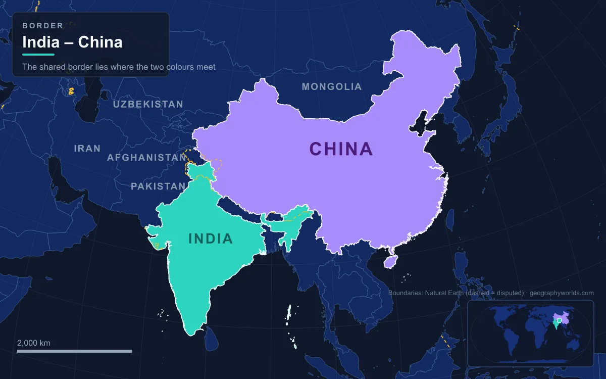
The phrase itself goes back to a letter of 7 November 1959, in which the Chinese premier Zhou Enlai proposed that both sides pull back 20 km from “the line up to which each side exercises actual control”. Jawaharlal Nehru rejected the idea, arguing the two governments could not even agree on who held what. After the Sino-Indian War of October–November 1962, the ceasefire positions became the working boundary, and the 1993 Agreement on the Maintenance of Peace and Tranquility along the LAC, followed by a 1996 agreement, committed both sides to respect the line without ever drawing it. What the LAC means on the ground is best seen place by place, from west to east.
Daulat Beg Oldi and the Depsang Plains: The Highest Meeting Point
The LAC starts in the far north of Ladakh, where Daulat Beg Oldi (DBO) sits at about 5,100 m on the northern edge of the Depsang Plains. The Karakoram Pass, on the old caravan route to Yarkand in the Tarim Basin, lies 8 km to the north; the LAC with Chinese-held Aksai Chin is roughly 9 km to the east. Winter temperatures fall to about −55 °C, and apart from the Siachen Glacier bases DBO is India’s northernmost settlement. An Indian post was set up here in the summer of 1960, and its advanced landing ground is among the highest airstrips in the world. The Darbuk–Shyok–DBO road, completed in 2019 along the old winter caravan route up the Shyok valley, now links it to the rest of Ladakh.
DBO is where the two armies meet at the highest of their five formal Border Personnel Meeting (BPM) points, opened in 2015 opposite the Chinese camp at Tianwendian. It is also where the fragility of the line showed in 2013, when a three-week standoff about 30 km southeast of DBO ended only after India agreed to dismantle military structures near Chumar, more than 250 km to the south.
Galwan, Pangong Tso and the Chushul–Moldo Hut
South of the Depsang Plains the LAC crosses the Galwan valley. The Galwan River rises near the old camping ground of Samzungling in Chinese-administered Aksai Chin, cuts west through about 48 km of Karakoram gorges and joins the Shyok 102 km south of DBO. It carries the name of Ghulam Rasool Galwan (1878–1925), a Ladakhi caravan leader, one of the rare major features in the region named after a local explorer. In 1962 an Indian forward post in the upper valley was overrun. On 15–16 June 2020 the valley saw hand-to-hand fighting in which 20 Indian soldiers died, and in February 2021 Chinese state media honoured four PLA soldiers killed there. That September, shots were fired along the LAC for the first time in 45 years.
Further south lies Pangong Tso, a saline lake at about 4,300 m that stretches 134 km but is only 5 km across at its widest. The LAC runs through the water: roughly two-thirds of the lake is administered by China and the western third by India, and both shores became standoff sites in 2020. Disengagement from both banks was completed in February 2021.
About 16 km south of the lake is Chushul, a village in the Chushul Valley where the LAC runs about 8 km to the east. The meeting hut at Spanggur Gap, called Chushul–Moldo after the villages on each side, became the venue for the corps-commander talks that followed 2020; the 14th round took place there on 12 January 2022. At the southern end of the western sector, the LAC in the Demchok area follows the Charding Nullah, a stream named as the Ladakh–Tibet boundary in a treaty of 1684, with one Demchok village on each bank. An October 2024 agreement on patrolling arrangements was followed on 3 December 2024 by India’s foreign minister telling parliament that disengagement in eastern Ladakh had been “achieved in full”.
Shipki La and Lipulekh: Trade and Pilgrim Passes of the Middle Sector
The middle sector, facing Tibet’s Ngari Prefecture, is shorter and quieter. At Shipki La, on the edge of Himachal Pradesh’s Kinnaur district near the village of Khab, the Sutlej River (Langqên Zangbo in Tibet) enters India. A spur road climbs to 4,720 m just southwest of the pass, but the crossing is used only for small-scale local trade and is closed to outsiders. For centuries wool, pashm and salt moved through here to the Lavi fair at Rampur Bushahr, held every November and still running, though Tibetan traders no longer attend as they once did.

Lipulekh, at about 5,115 m (16,780 ft) in Uttarakhand, is the pilgrims’ pass. It sits close to the India–Nepal–China trijunction and leads to the Tibetan market town of Purang (Taklakot) and on to Mount Kailash and Lake Manasarovar. India and China named it a border trade point in 1991, and in May 2020 an 80 km Border Roads Organisation road from Ghatiabagarh to the pass cut the pilgrimage from two or three weeks to about one. The Kailash Mansarovar Yatra, which has crossed here since 1981, stopped after 2019 and resumed in June 2025; on 30 April 2026 India announced that summer’s yatra for 1,000 pilgrims in batches of 50, using Lipulekh and Nathu La. Lipulekh also shows that the LAC is not the only line in play: Nepal claims the Kalapani area south of the pass, which India administers, and on 3 May 2026 it formally objected to the route. India rejected the objection, saying the yatra had used Lipulekh since 1954.
Nathu La: The Sikkim Pass Where the Two Armies Stand Closest
Sikkim’s short stretch of boundary lies between the middle and eastern sectors. Its best-known crossing, Nathu La, stands at about 4,310 m on the Dongkya Range, 52–54 km east of Gangtok and about 35 km from Yadong in Tibet’s Chumbi Valley. Before 1962, some 200 mules each carrying about 80 kg made the 20–25 day journey from Gangtok to Lhasa, taking cotton cloth, cereals and even dismantled scooters north and bringing back wool, silk and musk.

The pass was sealed after the 1962 war and saw fatal clashes in 1967. It reopened to trade in July 2006, with business allowed Monday to Thursday; India initially exempted 29 export items and 15 import items from duty, adding 12 more in 2012. Snow limits trading to roughly May to November, and volumes have fallen well short of the forecasts made before reopening; in 2010 and 2011 Sikkim recorded no imports through the pass at all. Soldiers here are posted closer to each other than almost anywhere else on the border, Nathu La is one of the five BPM points, and pilgrims to Kailash have a second route through it. In 2020 even this sector saw scuffles near the Sikkim–Tibet boundary.
Bum La and Kibithu: The McMahon Line in Arunachal Pradesh
East of Bhutan, the LAC broadly follows the McMahon Line, agreed between British India and Tibet in March 1914 as part of the Simla Convention; the People’s Republic of China disputes its legal status. The main crossing is Bum La, at about 4,613 m, roughly 40 km north of Tawang on an old traders’ route to Tsona Dzong in Tibet. Chinese troops advanced through here in 1962, and the pass saw fierce fighting. In 2006 the pass reopened to traders for the first time in 44 years, and the two armies held ceremonial meetings there every 15 August from 2006 to 2016, until the Chinese side stayed away in 2017 during the Doklam standoff. Indian civilians can visit with army permission. Reaching it became easier in March 2024, when the Sela Tunnel opened beneath the 4,170 m Sela Pass, giving Tawang an all-weather road.
The last meeting point is at the far eastern end. Kibithu, in Anjaw district on the Lohit River, is one of India’s easternmost permanently inhabited villages and is often called “India’s first village”. The Lohit enters India just to the north at Kaho, where a BPM point opened in May 2015, and the India–China–Myanmar tripoint near the Diphu Pass is about 40 km away. Nearby Walong gave its name to one of the battles of 1962.
From Depsang to Kibithu, the LAC is less a single line than a chain of places where two governments have learned to meet, trade and, at times, fight without agreeing where the border is. For the treaty behind the eastern sector, read our guide to the McMahon Line; for India’s other disputed frontier, see the Kashmir border dispute; and for the high country on the Chinese side, explore the Tibetan Plateau.