
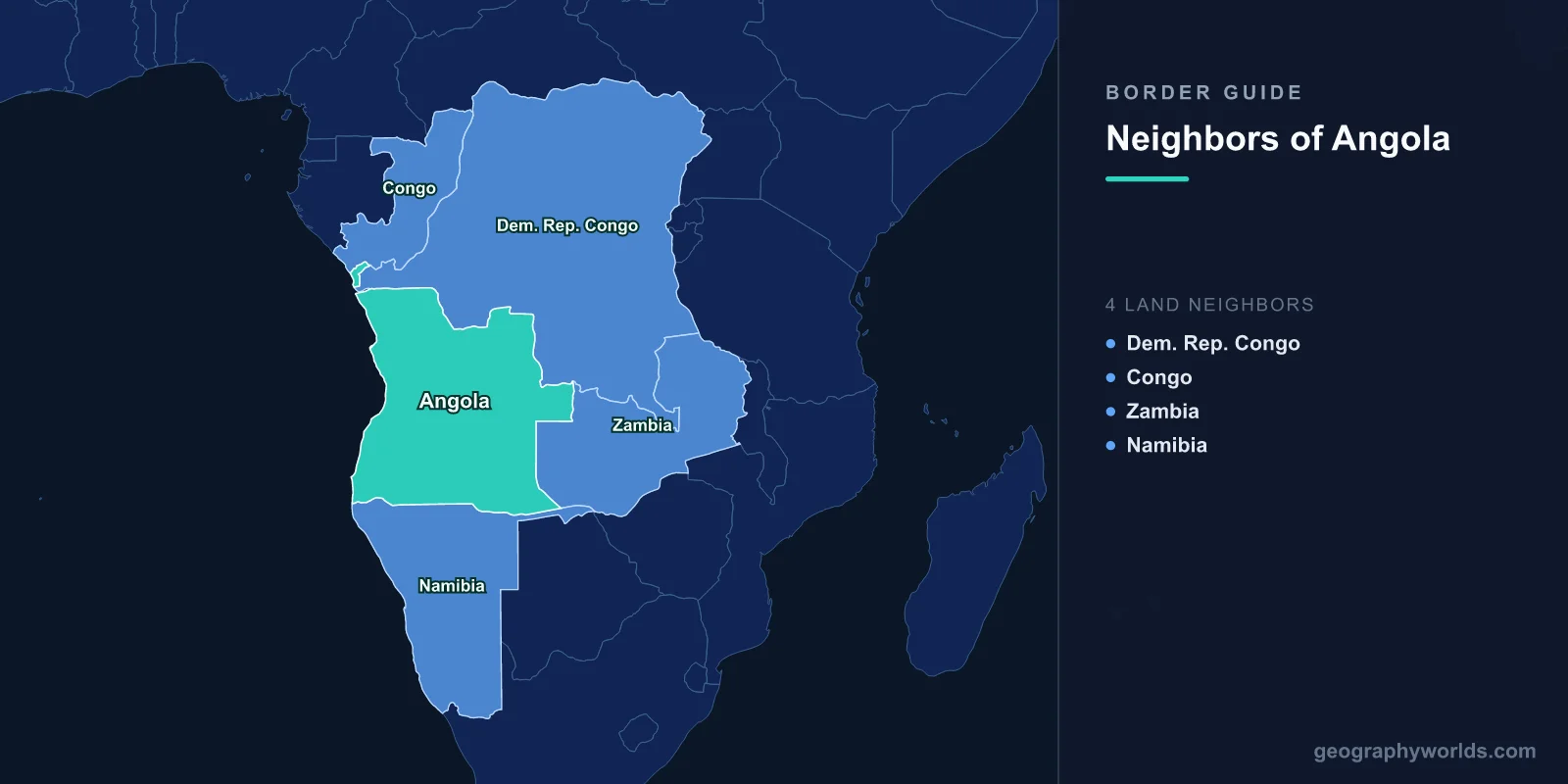
Angola shares land borders with four countries: the Democratic Republic of the Congo to the north and east, the Republic of the Congo to the far north, Zambia to the east, and Namibia to the south. The DRC boundary alone runs about 2,640 kilometres, the longest of the four by a wide margin. The Atlantic forms the western edge, and one Angolan province sits detached from the rest of the country entirely.
The Province That Does Not Touch Angola
Cabinda is Angolan territory, but it does not border Angola. It lies north of the mouth of the Congo river, cut off from the main body of the country by a strip of DRC territory roughly 60 kilometres wide — the corridor that gives the Democratic Republic of the Congo its short Atlantic coastline. Cabinda's own land borders are with the Republic of the Congo to the north and the DRC to the east and south.
This arrangement was formalised at the Berlin Conference and in the Anglo-Portuguese and Franco-Portuguese agreements that followed. Portugal held Cabinda under a separate 1885 protectorate treaty with local rulers, and it was administered as a distinct entity for much of the colonial period before being absorbed into Angola.
That history is the basis of a separatist claim. The Front for the Liberation of the Enclave of Cabinda has fought a low-intensity insurgency since the 1970s, arguing that Cabinda was never legitimately part of Angola. The stakes are not symbolic: Cabinda's offshore fields have long produced a substantial share of Angolan oil, which is the main reason Luanda has never entertained the argument.
A Border Drawn to Reach the Sea
The DRC's narrow corridor to the Atlantic exists because King Leopold II insisted on it. A landlocked Congo Free State would have depended entirely on Portuguese or French ports, and the Berlin Conference settlement gave Leopold a sliver of coast at the river mouth — around 40 kilometres of shoreline for a territory the size of Western Europe.
The consequence for Angola was permanent partition of its northern territory, and the consequence for the Congo was a coastline so short and so poorly suited to modern shipping that the country's main outlet has often been the ports of neighbouring states instead.
The Pink Map, and the Ultimatum That Killed It
Angola's eastern boundary might have looked very different. In 1886 Portugal published the Mapa Cor-de-Rosa, the Pink Map, claiming a continuous band of territory across the continent from Angola to Mozambique — the whole of what is now Zambia, Zimbabwe and Malawi.
Britain, with Cecil Rhodes pressing for a Cape-to-Cairo corridor running the other way, refused. The British Ultimatum of January 1890 demanded Portuguese withdrawal from the disputed territory, and Lisbon complied. The humiliation destabilised the Portuguese monarchy and is often cited as a step toward its fall in 1910.
What survived is the line Angola has today: a long eastern boundary with Zambia, drawn by the 1891 treaty and running for stretches along parallels and meridians rather than along anything on the ground.
The Longest Border, and the Least Governed
The frontier with the DRC crosses savanna, forest and the diamond fields of the Lunda provinces, and for most of its length there is little state presence on either side. It is crossed constantly and mostly informally — by traders, by artisanal miners and by people fleeing whatever is happening on the other side.
Diamonds are the reason the border has a security apparatus at all. Angola's Lunda Norte and Lunda Sul provinces hold rich alluvial deposits, and Congolese miners have crossed to work them for decades. Angola has responded with mass expulsions, the largest of which removed several hundred thousand people in 2018, conducted with a speed and roughness that drew condemnation from the United Nations and a retaliatory expulsion of Angolans from the DRC.
Zambia, and the Peoples the Line Runs Through
The Zambian border runs about 1,110 kilometres through the high plateau of eastern Angola. It divides the Lunda, Luvale, Chokwe and Luchazi peoples, whose territories predate both states, and cross-border kinship remains the organising fact of life along it.
During Angola's civil war this was a strategic problem. Zambia's location made it a route for supplies and a refuge, and hundreds of thousands of Angolan refugees crossed east during the fighting; Meheba camp in north-western Zambia was among the largest and longest-running settlements of its kind in Africa. Many residents stayed for decades, and Zambia eventually offered a path to local integration.
Namibia, the Kunene and a Panhandle
The southern boundary with Namibia follows the Kunene river in the west and the Okavango in the east, with a long straight section between them. It was drawn by Germany and Portugal in 1886 and adjusted in 1926, which is why it combines river courses with abrupt geometric lines.
At the eastern end the border meets the Zambezi Region — the strip formerly called the Caprivi Strip, a corridor of Namibian territory about 450 kilometres long and in places only 30 wide, extending east to the Zambezi. It exists because the Heligoland-Zanzibar Treaty of 1890 gave German South West Africa access toward the river, on the mistaken assumption that this would open a route to the Indian Ocean. Victoria Falls, which lies downstream, makes the Zambezi unnavigable from that point, so the corridor never served its purpose.
During the apartheid era this border was militarised: South African forces operating from Namibia crossed repeatedly into southern Angola, and the campaign culminated in the fighting around Cuito Cuanavale in 1987 and 1988, which preceded the settlement that brought Namibian independence.
Rivers That Begin Here and Matter Elsewhere
Angola's central plateau is one of Africa's great watersheds, and several rivers that define or cross its borders are more consequential downstream than at home.
The Okavango rises in the Angolan highlands and flows south-east to spill into the Kalahari as the Okavango Delta, one of the largest inland deltas on earth and the basis of Botswana's tourism economy. Because the headwaters are Angolan, decisions about irrigation and dams in Angola have direct consequences for Botswana, and the three basin states manage it through a joint commission.
The Zambezi's headwaters also rise near the Angola-Zambia boundary, and the Kwango and Kasai flow north into the Congo system. A country that is often described as oil-dependent is also, hydrologically, upstream of much of southern Africa.
How the Borders Fed the War
Angola's civil war lasted from independence in 1975 until 2002, and its borders were the mechanism that kept it going. UNITA's supply lines ran through Zaire under Mobutu and, earlier, through Zambia and Namibia; the MPLA government was supported by Cuban forces arriving by sea and Soviet materiel.
When the Cold War sponsors withdrew, UNITA financed itself by exporting diamonds across the northern and eastern borders — the trade that produced the phrase conflict diamonds and eventually the Kimberley Process certification scheme. The war ended in 2002 only after Jonas Savimbi was killed and those routes had been substantially closed.
Trade That Runs the Wrong Way
Angola's borders reveal an odd economic pattern: for a country with four land neighbours, remarkably little of its trade crosses them. Oil goes out by tanker, imports arrive by container at Luanda and Lobito, and the great majority of Angolan commerce never touches a land frontier at all.
The Lobito Atlantic Railway is the attempt to change that. The Benguela railway, completed under Portuguese rule in 1929, ran from the port of Lobito to the Congolese border and onward to the Copperbelt, and it was built precisely to carry Katangan and Zambian minerals to the Atlantic. The war destroyed it; bridges were blown, track was lifted and mines were laid along the route, and it ceased to function for decades.
Rehabilitation was completed in the 2010s with Chinese contractors, and in 2023 a European and American-backed consortium took over its operation with the explicit aim of moving cobalt and copper from the DRC and Zambia to the Atlantic rather than east to the Indian Ocean. The corridor has become a piece of great-power competition over critical minerals, and its viability depends entirely on two of Angola's land borders working properly.
The Coast Angola Faces
Angola's Atlantic frontage runs about 1,600 kilometres, and the cold Benguela Current that flows north along it makes the coastal strip arid — the Namib desert continues north across the Namibian border into Angola's Namibe province, one of the driest inhabited places on the continent.
Offshore, Angola's maritime boundaries with the DRC, the Republic of the Congo and Namibia matter because the oil does. A long-running disagreement with the DRC over the maritime boundary off Cabinda concerns fields that straddle any plausible line, and the two states have periodically discussed joint development rather than delimitation.
For a country whose borders were drawn in European capitals in the 1880s and 1890s, that is a fitting modern postscript: the lines that matter most now are the ones out at sea. Angola in the round is our Angola country guide, and the waterway whose mouth cut Cabinda off is traced in our Congo river guide.
