
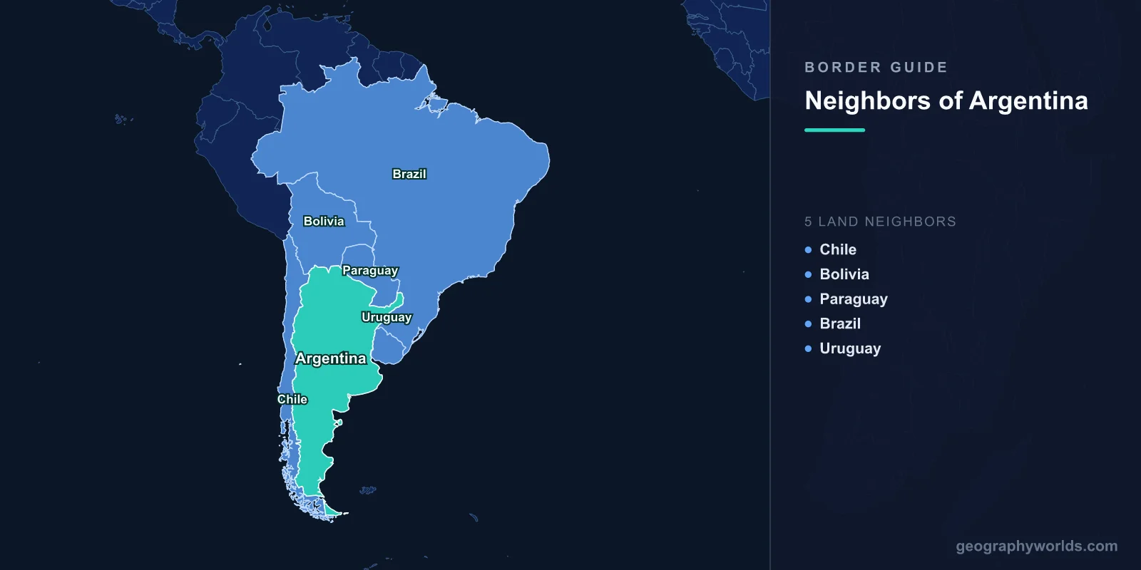
Argentina shares land borders with 5 countries: Chile (5,308 km), Bolivia (942 km), Paraguay (2,531 km), Brazil (1,263 km), and Uruguay (541 km), totaling approximately 10,585 km of land boundaries.
Introduction
As South America's second-largest country, Argentina stretches from the subtropical north to the sub-Antarctic south, spanning over 3,400 km from the Tropic of Capricorn to Tierra del Fuego. Its borders encompass extraordinary geographic diversity: the Andes Mountains form the world's longest mountain frontier with Chile, while rivers — the Paraná, Paraguay, Uruguay, and Río de la Plata — define most of the eastern borders. Argentina's position at the southern cone of South America gives it a unique mix of Andean, Pampean, and Patagonian border landscapes.

Complete List of Countries Bordering Argentina
- Chile: 5,308 km
- Paraguay: 2,531 km
- Brazil: 1,263 km
- Bolivia: 942 km
- Uruguay: 541 km
Argentina's five borders total over 10,500 km, with the Chilean frontier alone accounting for more than half. Argentina also claims sovereignty over the Falkland Islands (Islas Malvinas), which are administered by the United Kingdom, and a large sector of Antarctica. Maritime boundaries extend into the South Atlantic Ocean.
Western Border: Chile
- Border length: 5,308 km — the world's third-longest international border
- Terrain: Follows the Andes mountain chain from Bolivia to Tierra del Fuego
- Highest crossing: Paso de Jama at 4,230 meters, and Cristo Redentor/Uspallata at 3,832 meters
The Argentina-Chile border is the world's third-longest international boundary at 5,308 km, running along the crest of the Andes Mountains from the Bolivian tripoint in the north to the Strait of Magellan and Tierra del Fuego in the south. This frontier crosses every climate zone from desert to glacial, including the Atacama, the lake district, and the Patagonian ice fields.
The Andes along this border include some of the Western Hemisphere's highest peaks, such as Aconcagua (6,961 m), the tallest mountain outside Asia. The border was the subject of a famous near-war in 1978 over the Beagle Channel islands, resolved by papal mediation in 1984. The Christ the Redeemer of the Andes statue, erected at the Uspallata Pass in 1904, commemorates the peaceful resolution of earlier border disputes. Today, the two countries are connected by numerous mountain passes, though winter snow frequently closes the higher crossings.
Northern Borders: Bolivia and Paraguay
- Bolivia border: 942 km — from the Andes highlands to the Gran Chaco
- Paraguay border: 2,531 km — Argentina's second-longest, along rivers and the Chaco
The Argentine-Bolivian border (942 km) descends from the Andean altiplano — the high plateau at over 3,500 meters — into the subtropical lowlands. The border region includes the Quebrada de Humahuaca, a UNESCO World Heritage Site of dramatic desert gorges. La Quiaca-Villazón is the primary border crossing, a bustling gateway between the two countries.
The Paraguay border (2,531 km) is Argentina's second-longest, defined largely by the Pilcomayo, Paraguay, and Paraná rivers. The Gran Chaco, one of South America's last great wilderness areas, straddles this frontier. The Chaco War (1932-1935) between Bolivia and Paraguay — though not involving Argentina — was fought over this border region's resources. The Yacyretá Dam on the Paraná River is a major joint Argentine-Paraguayan hydroelectric project.
Eastern Borders: Brazil and Uruguay
- Brazil border: 1,263 km — from the Iguazu Falls to the Uruguay River
- Uruguay border: 541 km — along the Uruguay River and Río de la Plata estuary
The Argentine-Brazilian border (1,263 km) begins spectacularly at Iguazu Falls, where 275 waterfalls cascade over basalt cliffs shared by both countries. The border follows the Iguazú River and then the Uruguay River southward. The Misiones province, a narrow strip of Argentine territory between Brazil and Paraguay, is covered in remnant Atlantic Forest, one of the world's most endangered biomes.
The Uruguay border (541 km) follows the Uruguay River to its outlet at the Río de la Plata estuary. Buenos Aires and Montevideo sit on opposite banks of this vast estuary, just 200 km apart. The two capitals have deep cultural ties — both are centers of tango, mate-drinking culture, and the Spanish dialect known as Rioplatense. A fleet of ferries connects the two cities across the river.
Historical Border Changes
Argentina's borders were largely established through 19th-century treaties following independence from Spain. The most dramatic territorial dispute was with Chile over the Andes and Patagonia, culminating in the 1881 Boundary Treaty that used the watershed principle along the mountain crest. The Beagle Channel dispute in 1978 nearly led to war before Pope John Paul II's mediation resolved it in 1984. Argentina fought Britain over the Falkland Islands (Islas Malvinas) in 1982, losing the conflict but maintaining its sovereignty claim. The Triple Alliance War (1864-1870) against Paraguay shaped the northeastern borders. Argentina also claims a sector of Antarctica (overlapping British and Chilean claims) based on proximity and historical presence.
Key Facts
- Argentina borders 5 countries with over 10,500 km of total land boundaries
- The Chile border (5,308 km) along the Andes is the world's third-longest international frontier
- The Iguazu Falls on the Brazil border consist of 275 individual waterfalls
- Argentina and Chile nearly went to war in 1978 over the Beagle Channel islands
- Argentina maintains sovereignty claims over the Falkland Islands (Malvinas) and a sector of Antarctica
Fun Facts
- The Christ the Redeemer of the Andes statue at the Argentine-Chilean border was made from melted-down Argentine cannons as a symbol of peace.
- Aconcagua (6,961 m), the highest peak in the Western Hemisphere, sits just 15 km from the Chilean border in Mendoza province.
- Buenos Aires and Montevideo are the closest national capitals in South America, separated by just 200 km across the Río de la Plata.
- The Argentine-Chilean border in Tierra del Fuego runs through the world's southernmost city — Ushuaia (Argentina) — often called "the end of the world."
Final Thoughts
Argentina's five borders showcase the geographic extremes of South America — from the Andean peaks along the world's third-longest border with Chile to the thundering Iguazu Falls on the Brazilian frontier, from the subtropical Chaco wilderness to the windswept reaches of Tierra del Fuego. These borders have been shaped by wars, treaties, and papal intervention, creating a fascinating tapestry of South American history and geography.
Test Your Knowledge!
Think you know your borders and boundaries? Try our interactive geography quiz!
Play Geography Games →