
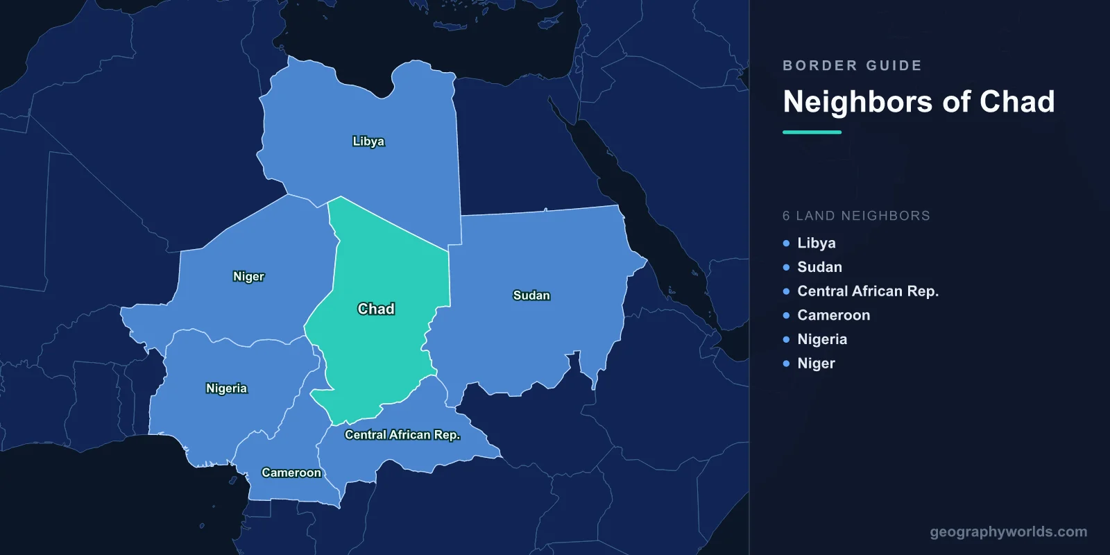
Chad shares land borders with six countries: Libya to the north, Sudan to the east, the Central African Republic to the south, Cameroon and Nigeria to the south-west, and Niger to the west. It is landlocked and enormous — the fifth-largest country in Africa — and the nearest port is more than a thousand kilometres away. Every one of those six borders has carried a war in the past fifty years.
A Capital Pressed Against the Border
N'Djamena sits on the Chari river directly opposite the Cameroonian town of Kousséri, which makes it one of the very few national capitals located on an international frontier. A bridge connects the two, and the daily movement across it is closer to commuting than to international travel.
The position is a vulnerability. Rebel columns have reached the capital more than once — in 2006 and again in 2008, when fighters who had crossed from Sudan fought in the streets — and the proximity of the border means an assault on N'Djamena is also an international incident.
It is also why Cameroon matters so much to Chad: the road from N'Djamena to Douala is the country's lifeline, and it starts on the far bank of the river.
The Aouzou Strip
The most consequential border dispute in Chad's history concerned a band of territory along the Libyan frontier roughly 100 kilometres deep, known as the Aouzou Strip, believed to contain uranium.
Libya's claim rested on a 1935 treaty between France and Italy that was signed but never ratified. Muammar Gaddafi occupied the strip in 1973 with the acquiescence of a Chadian government that needed Libyan support, and Libya subsequently administered it, issued identity documents and stationed forces there.
The Toyota War
Chad fought to recover it. The decisive phase came in 1987, in a campaign that became known as the Toyota War because the Chadian forces were mounted on pickup trucks fitted with anti-tank missiles and machine guns.
Against a conventional Libyan force with armour, aircraft and fixed bases, the tactic worked to a degree that surprised every observer. Chadian columns overran positions at Fada and Ouadi Doum, destroyed or captured large quantities of equipment, and even raided the Libyan airbase at Maaten al-Sarra. Libyan losses ran into the thousands, and a ceasefire followed in September 1987.
The World Court Ends It
The two states referred the territorial question to the International Court of Justice, which ruled in February 1994 that the boundary had been established by a Franco-Libyan treaty of 1955 and that the Aouzou Strip was Chadian.
Libya complied. Its forces withdrew under United Nations observation by the end of May 1994, and the transfer was completed without incident. It stands alongside the Bakassi handover between Nigeria and Cameroon as one of the few African territorial rulings implemented in full.
Lake Chad Is a Quadripoint, and It Is Shrinking
At the south-western corner, Chad, Niger, Nigeria and Cameroon meet in Lake Chad. The lake has contracted drastically since the 1960s through drought and irrigation withdrawal, and its retreat has left the boundary running through land that used to be water.
New islands and dry beds have emerged, and their sovereignty is not always clear. Fishing communities have followed the water, farmers have moved onto the exposed bed, and herders have converged on what remains — all across lines that mean little on the ground.
The Lake Chad Basin Commission was established to manage the shared resource and now spends much of its effort on security, since the same conditions that make the lake ungoverned make it useful to armed groups.
Boko Haram and the Joint Task Force
From 2015 Boko Haram attacked into Chad's Lac province, and Chad responded with the most effective military of the four riparian states, deploying into Nigeria, Niger and Cameroon.
The Multinational Joint Task Force gave those deployments a framework, permitting pursuit across borders that the insurgents ignored entirely. Chadian forces acquired a regional reputation, which became a diplomatic asset — and, after a deadly attack on a Chadian base at Bohoma in 2020 that killed around a hundred soldiers, a domestic political problem.
Darfur Is on the Other Side
The eastern border with Sudan runs about 1,400 kilometres through arid country, and the Zaghawa people live on both sides of it — as did Chad's ruling family, since Idriss Déby was Zaghawa.
That kinship made the Darfur conflict a Chadian conflict. From 2003, hundreds of thousands of Darfuri refugees crossed west, and the two governments fought a proxy war through each other's rebels: Khartoum backed Chadian insurgents who attacked N'Djamena, and N'Djamena backed Darfuri groups. It was resolved in 2010 by an agreement to stop, and by a rare joint border force patrolling the frontier together.
The 2023 War and Eastern Chad
When war broke out between the Sudanese army and the Rapid Support Forces in April 2023, the border reopened as a humanitarian emergency. Hundreds of thousands of people crossed into eastern Chad, arriving in Adré and other border towns in one of the fastest displacement events anywhere in recent years.
Chad, already hosting refugees from Sudan, the Central African Republic and Nigeria, became one of the largest refugee-hosting countries in Africa relative to its own population. The eastern provinces receiving them are among the poorest and driest in the country.
Tibesti, Gold and the Route North
The Tibesti mountains in the far north, a volcanic massif rising above 3,400 metres, straddle the Libyan border and are the homeland of the Toubou. The range is remote enough that central authority has rarely reached it.
A gold rush in the region from around 2012 drew thousands of miners, along with armed groups taxing the sites and trafficking routes moving north into Libya. The state's response has included aerial bombardment of mining areas, and control of the zone has been contested between government forces, Toubou armed groups and traffickers.
Rebels Who Arrive From the North
Chad's chronic insecurity has an external mechanism: opposition movements base themselves in southern Libya and drive south. The Front for Change and Concord in Chad launched such a column in April 2021, and President Idriss Déby was killed at the front while visiting his forces, after three decades in power.
His son took over at the head of a transitional military council, and the pattern has not changed. As long as southern Libya remains outside any state's control, Chad's northern border functions as an entry point rather than a barrier.
Six Borders and Three Climate Zones
Chad stretches roughly 1,800 kilometres from north to south, and its borders touch three entirely different environments. The Libyan and northern Nigerien frontiers run through true desert, where rainfall is negligible and the Tibesti and Ennedi massifs are the only relief. The central band, along the Sudanese and Nigerien borders, is Sahel — thorn scrub, seasonal rain, pastoralism. The south, toward the Central African Republic and Cameroon, is wooded savanna with reliable rains, and it is where the cotton, the cereals and most of the population are.
That gradient is the country's central political problem. Power has been held since the 1980s by northern, largely Muslim elites from the desert and Sahel zones, while much of the agricultural production and a large part of the Christian and animist population is in the south. The civil wars of the 1960s to 1980s ran substantially along that axis, and southern grievance over the distribution of oil revenue — the Doba fields are in the south — has never been settled.
Ennedi, in the north-east near the Sudanese border, is a UNESCO World Heritage site, a sandstone massif of arches and canyons holding rock art thousands of years old and a relict population of desert crocodiles in the Guelta d'Archei. It is a reminder that the Sahara here was green within the span of human settlement, and that the border zones Chad now struggles to govern were once its most populated ground.
The Toubou and the Zaghawa Do Not Recognise These Lines
Two peoples straddle Chad's most consequential borders. The Toubou occupy the Tibesti and the desert on both sides of the Libyan frontier, and their networks run north to Sebha and Kufra; Libya's own Toubou communities fought in that country's civil war, and the relationship is one of the reasons movement across the northern border is so hard to interdict.
The Zaghawa straddle the Sudanese line, with communities in Darfur and in Chad's Ennedi and Wadi Fira regions. Because Chad's ruling family is Zaghawa, that kinship has repeatedly drawn the state into Sudanese conflicts and Sudanese conflicts into the state. Neither people regards the boundary as anything other than an administrative inconvenience, and both have used it as an asset for as long as it has existed.
The Southern Border and the Pipeline
The Central African Republic border runs through savanna and has carried refugees, armed groups and cattle raiders in both directions, with the CAR's successive conflicts spilling north and Chadian herders moving south into contested grazing.
The Cameroonian border carries the country's economy. Chadian crude, produced in the Doba basin since 2003, travels by a 1,070-kilometre pipeline across Cameroon to an offshore terminal near Kribi. Everything Chad imports comes the other way by road. Six borders, and only one of them leads to a ship. Chad in the round is our Chad country guide, while the geography of the Sahara describes the desert filling its northern half.
