
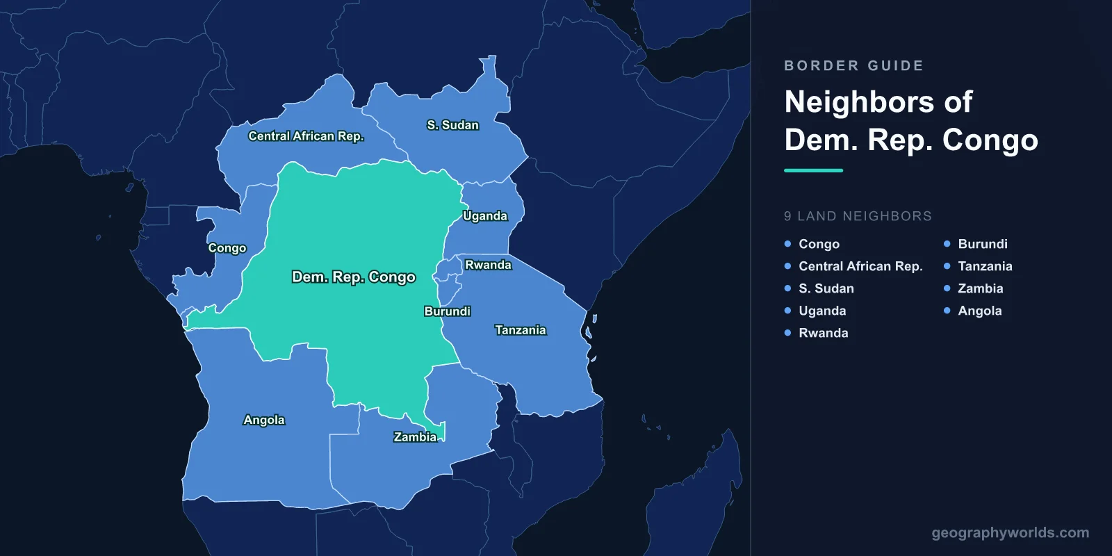
The Democratic Republic of Congo (DRC) shares land borders with nine countries: Republic of Congo and the Angolan exclave of Cabinda to the west, Central African Republic and South Sudan to the north, Uganda, Rwanda, Burundi, and Tanzania to the east, and Zambia and Angola to the south.
Introduction
The DRC is Africa's second-largest country (2.34 million km²), roughly the size of Western Europe. Its nine borders make it the most connected nation in Africa. The Congo River, Africa's second-longest, defines much of the western border, while the Albertine Rift (part of the East African Rift) marks the mountainous eastern frontier. The DRC's borders encompass the world's second-largest tropical rainforest.

Overview of DRC's Borders
- Total Land Borders: 10,481 km
- Number of Neighbors: 9 countries (+ Cabinda exclave of Angola)
- Longest Border: Angola (2,646 km including Cabinda)
- Key Feature: Congo River, Great Rift Valley, Congo Basin rainforest
The DRC's borders reflect the legacy of King Leopold II of Belgium's Congo Free State, carved out during the Scramble for Africa. The Congo River forms much of the western border with the Republic of Congo, while the eastern borders follow the Great Rift Valley and its associated lakes. The immense size of the country means border conditions vary from tropical rainforest to savanna to volcanic mountains.
The DRC's eastern borders have been the site of Africa's deadliest conflict since World War II. The First and Second Congo Wars (1996-2003) involved armies from Uganda, Rwanda, Angola, Zimbabwe, Namibia, Chad, and others. Eastern border regions remain unstable, with dozens of armed groups operating in North Kivu, South Kivu, and Ituri provinces.
Western Neighbors: Republic of Congo and Cabinda (Angola)
- Republic of Congo Border: 1,229 km
- Cabinda (Angola) Border: 253 km
- Key Feature: Congo River, twin capital cities
The Republic of Congo border at 1,229 km follows the Congo River for much of its length. The capital cities of Kinshasa (DRC) and Brazzaville (Republic of Congo) face each other across the river, making them the closest pair of national capitals in the world (after Vatican City-Rome). Despite this proximity, the two countries have distinct histories (Belgian vs. French colonial rule).
Cabinda, an Angolan exclave north of the Congo River mouth, shares a 253 km border with the DRC. This small oil-rich territory is separated from mainland Angola by a strip of DRC territory. Cabinda produces most of Angola's oil but has an active separatist movement.
Northern Neighbors: Central African Republic and South Sudan
- CAR Border: 1,747 km
- South Sudan Border: 714 km
- Key Feature: Dense forest, Uele River
The Central African Republic border at 1,747 km runs through dense equatorial forest and along the Ubangi River. Both countries face severe instability, with armed groups operating on both sides. The Lord's Resistance Army (LRA), originally from Uganda, has operated in this border region. Cross-border displacement of civilians is common.
South Sudan's 714 km border crosses from the forest zone into savanna. This border was previously with Sudan before South Sudan's independence in 2011. Armed group activity and resource competition create tension. Gold mining in the DRC's Ituri province near this border has fueled conflict.
Eastern Neighbors: Uganda, Rwanda, Burundi, and Tanzania
- Uganda Border: 877 km
- Rwanda Border: 221 km
- Burundi Border: 236 km
- Tanzania Border: 473 km
The eastern borders are the DRC's most troubled and most geographically dramatic. Uganda (877 km) shares the Albertine Rift frontier, including the Rwenzori Mountains ("Mountains of the Moon"), Lake Albert, and Lake Edward. Rwanda (221 km) and Burundi (236 km) share borders along Lake Kivu and near the Virunga volcanoes, home to the endangered mountain gorilla.
These borders have been the epicenter of conflict since the 1994 Rwandan genocide spilled across into eastern Congo. Rwandan and Ugandan forces have repeatedly entered the DRC, and Rwanda-backed rebel groups (including M23) continue to operate in North Kivu. The Virunga National Park on the Rwandan/Ugandan border is a UNESCO World Heritage Site under constant threat from armed groups, poaching, and oil exploration.
Southern Neighbors: Zambia and Angola
- Zambia Border: 2,332 km
- Angola Border: 2,646 km (including Cabinda 253 km)
- Key Feature: Copper Belt, Katanga/Haut-Katanga province
Zambia's 2,332 km border runs through the mineral-rich Copperbelt region, one of the world's largest copper deposits spanning both countries. The DRC's Katanga (now Haut-Katanga) province produces copper, cobalt (60% of world supply), and other strategic minerals. Cross-border mining operations and mineral trade are economically significant.
Angola's total border at 2,646 km (including Cabinda) is the DRC's longest. This border crosses diverse terrain from the Atlantic coast to the interior highlands. Both countries experienced devastating civil wars and have large populations of refugees and displaced persons on both sides. The Kasai region near the Angolan border saw a militia uprising in 2016-2017 that displaced over a million people.
Key Facts
- The DRC borders 9 countries, the most of any African nation.
- Angola's border at 2,646 km (including Cabinda) is the DRC's longest.
- Kinshasa and Brazzaville across the Congo River are the closest national capitals in the world.
- The DRC produces 60% of the world's cobalt, a critical mineral for batteries.
- The Virunga Mountains on the Rwanda/Uganda border are home to endangered mountain gorillas.
Fun Facts
- The Congo River is so deep and wide that Kinshasa and Brazzaville have no bridge connecting them.
- The DRC is roughly the size of Western Europe combined.
- The conflict in eastern Congo since 1996 has killed an estimated 5-6 million people.
- Cabinda, an Angolan exclave, is separated from Angola by a strip of DRC territory.
Final Thoughts
The DRC's nine borders encompass Africa's most geographically vast and resource-rich nation, a country whose borders have been the site of the continent's deadliest conflicts. From the twin capitals on the Congo River to the gorilla habitat of the Virunga volcanoes to the cobalt mines of the Copperbelt, the DRC's borders define a nation of enormous potential trapped in cycles of instability.
Test Your Knowledge!
Think you know which countries share borders? Try our geography games!
Play Geography Games →