
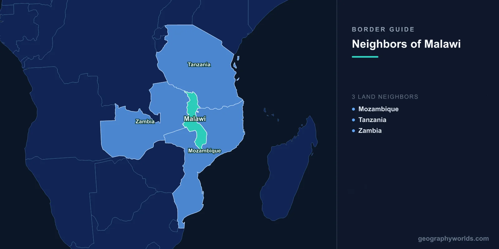
Malawi shares land borders with three countries: Mozambique, which wraps around it to the south, south-west and east; Tanzania to the north and north-east; and Zambia to the west. It is landlocked, long and narrow — some 900 kilometres from north to south and in places under 100 wide — and roughly a fifth of its territory is water, because Lake Malawi fills most of its eastern side. That lake is also the subject of the country's only serious territorial dispute.
A Border That Runs Along a Beach
Malawi's position is that the boundary with Tanzania runs along the eastern shoreline of Lake Malawi, which would make the entire surface of the lake Malawian right up to the Tanzanian beach. Tanzania's position is that it runs down the median line, as is standard practice for boundary lakes.
Malawi relies on the Heligoland-Zanzibar Treaty of 1890 between Britain and Germany, which placed the boundary at the eastern shore. Tanzania argues that a later agreement and subsequent practice moved it to the middle, and that the 1890 arrangement between two colonial powers cannot bind a successor state against ordinary principles.
The disagreement was dormant for decades and revived sharply in 2011, when Malawi licensed hydrocarbon exploration across the whole lake. Mediation by a forum of former African heads of state was attempted and stalled, and both sides have periodically threatened to go to international adjudication without doing so.
Why Mozambique's Section Is Settled
Malawi's boundary with Mozambique also runs through the lake, and there the two countries agree: it follows the median line, as fixed in the colonial period and accepted since.
That has an awkward implication for the Malawian case further north. If a median line is right against Mozambique, it is difficult to argue that a shoreline boundary is right against Tanzania on the same body of water, and Tanzanian officials have made exactly that point.
The southern part of the lake is unambiguously Malawian, including the Lake Malawi National Park at Cape Maclear, a UNESCO World Heritage site inscribed for its extraordinary fish fauna. The lake holds more species of fish than any other lake on earth — several hundred cichlids, the great majority found nowhere else — and the science is one of the standard textbook cases of rapid evolutionary radiation.
Almost Surrounded by One Country
Mozambique accounts for most of Malawi's frontier, wrapping around it on three sides. That makes Malawi's access to the outside world overwhelmingly a Mozambican question.
Two rail corridors run east to the Indian Ocean: the Nacala corridor to the deep-water port of Nacala, and the Beira corridor to the south. Both were built under colonial rule specifically to connect Nyasaland to the sea, and both are shorter than any southern alternative.
When the Mozambican civil war made both lines unusable in the 1980s, Malawi's trade was forced onto a far longer road route south through Zimbabwe and South Africa. The cost to a poor, landlocked, agricultural economy was severe, and it was compounded by the arrival of around a million Mozambican refugees — an extraordinary number for a country whose own population was then around eight million.
Banda, RENAMO and a Difficult Decade
Malawi's relations with its neighbours under Hastings Banda were unusual. He maintained diplomatic and economic relations with apartheid South Africa, alone among African leaders, and he was accused of permitting RENAMO to operate from Malawian territory against the Mozambican government.
That accusation sat alongside the fact that Malawi was simultaneously hosting a vast number of Mozambican civilians displaced by the same war. The relationship normalised after Mozambique's peace agreement in 1992 and Malawi's transition to multiparty politics in 1994, and the refugees largely returned.
The Zambian Border, and the Route West
The Zambian boundary runs about 840 kilometres along Malawi's western side through the Nyika plateau in the north and farmland further south. The main crossing at Mchinji, on the road from Lilongwe to Chipata and on to Lusaka, is busy and straightforward.
The relationship is the least complicated of the three. Both countries were part of the Federation of Rhodesia and Nyasaland from 1953 to 1963, an arrangement dominated by Southern Rhodesia which both Nyasaland and Northern Rhodesia campaigned to leave, and independence came within months of each other in 1964.
Zambia has also been an outlet of sorts: Malawian traffic has at points used Zambian routes toward Dar es Salaam, and the two countries share interests in the Nacala corridor, which serves Zambian traffic as well.
Karonga, and the Northern Corner
The Tanzanian border runs from the northern tip of the lake along the Songwe river to the Zambian tripoint. The Songwe is notoriously unstable, shifting its channel across the floodplain and moving the boundary with it, and a joint commission has worked for years on stabilising the river to fix the line.
Karonga, the main Malawian town in the far north, sits near the lakeshore below this border. It has become known for palaeontology — dinosaur remains and hominin fossils have been recovered from the area, which lies at the southern end of the East African Rift — and for uranium mining, which operated for several years and generated its own environmental controversy.
Why a Lake Dispute Matters to People Who Do Not Own Boats
The Tanzanian dispute is not only about hydrocarbons. Fishing rights are the day-to-day issue: Tanzanian fishers operating in waters Malawi considers exclusively its own have been arrested by Malawian patrols, and the reverse has also been alleged.
Lake Malawi supplies a very large share of the animal protein in the Malawian diet, and catches have declined significantly through overfishing and habitat loss. In that context, control over water is control over food, and neither government can concede the point easily.
The lake also fluctuates dramatically in level, and the Shire river, its only outlet, drives the hydroelectric plants that supply most of Malawi's electricity. Low lake levels have meant national power shortages, which ties the border question to the grid.
A Border Drawn by a Missionary’s Route
Malawi's shape — long, thin and wrapped around a lake — is a consequence of who arrived first. David Livingstone reached the lake in 1859, and the Scottish missions that followed established themselves along its shores at Livingstonia, Blantyre and Cape Maclear, with the African Lakes Company operating steamers to supply them.
When Britain declared a protectorate in 1891, it drew the boundary to enclose the mission and trading stations rather than any coherent geographic unit, and Cecil Rhodes's British South Africa Company financed the administration in exchange for a free hand further west. The result was a colony consisting essentially of a lakeshore and its immediate hinterland, with no port, no mineral wealth and a boundary that cut through the Chewa, Tumbuka, Yao and Ngoni.
The economic model that followed was migrant labour. Nyasaland exported men to the mines of South Africa and the farms of Southern Rhodesia in very large numbers for most of the twentieth century, under formal recruitment agreements, and remittances rather than exports sustained the territory.
A Lake That Rises and Falls
Lake Malawi's level fluctuates far more than most large lakes, and the record is dramatic: it fell so low in the early nineteenth century that the Shire river, its only outlet, stopped flowing altogether, and it rose enough in the 1980s to flood lakeshore settlements.
Because the Shire drives the hydroelectric stations that supply the great majority of Malawi's electricity, the lake's level is effectively the country's power supply. Low water has produced prolonged national load-shedding, and a barrage at Liwonde is used to regulate outflow.
The Shire then runs south and joins the Zambezi inside Mozambique, which means Malawi's drainage leaves through a neighbour before reaching the sea — the hydrological version of the transport problem that defines the country.
Dzaleka, and Refugees in Both Directions
Malawi hosted around a million Mozambicans during the 1980s and now hosts a refugee population of its own, concentrated at Dzaleka camp north of Lilongwe. Opened in 1994 on the site of a former political prison, it was built for around 10,000 people and holds several times that, with arrivals mainly from the Democratic Republic of the Congo, Burundi and Rwanda.
Malawi maintains an encampment policy with reservations on the refugee convention restricting the right to work and to move freely, and in 2023 it forcibly relocated refugees who had settled and opened businesses in towns back into the camp. Dzaleka is nonetheless a substantial commercial centre, with a market serving the surrounding Malawian villages, and it has an annual arts festival that draws visitors from the capital.
A Corridor Country
Landlocked, narrow and long, Malawi is in transport terms a corridor rather than a hub. Its exports — tobacco above all, along with tea, sugar and increasingly legal cannabis — are bulky and low value relative to weight, which makes freight costs decisive.
The Nacala corridor railway, rehabilitated in the 2010s in connection with Mozambican coal exports from Tete, runs through Malawian territory on its way to the coast, which gives Malawi transit revenue and a working line at the same time.
It is the closest thing the country has to a strategic advantage from its geography: the shortest route from the Mozambican coalfields to the ocean happens to cross Malawi. Malawi more broadly is our Malawi country guide; the lake itself is covered in the geography of Lake Malawi, and our Zambezi guide follows the system its outflow eventually joins.
