
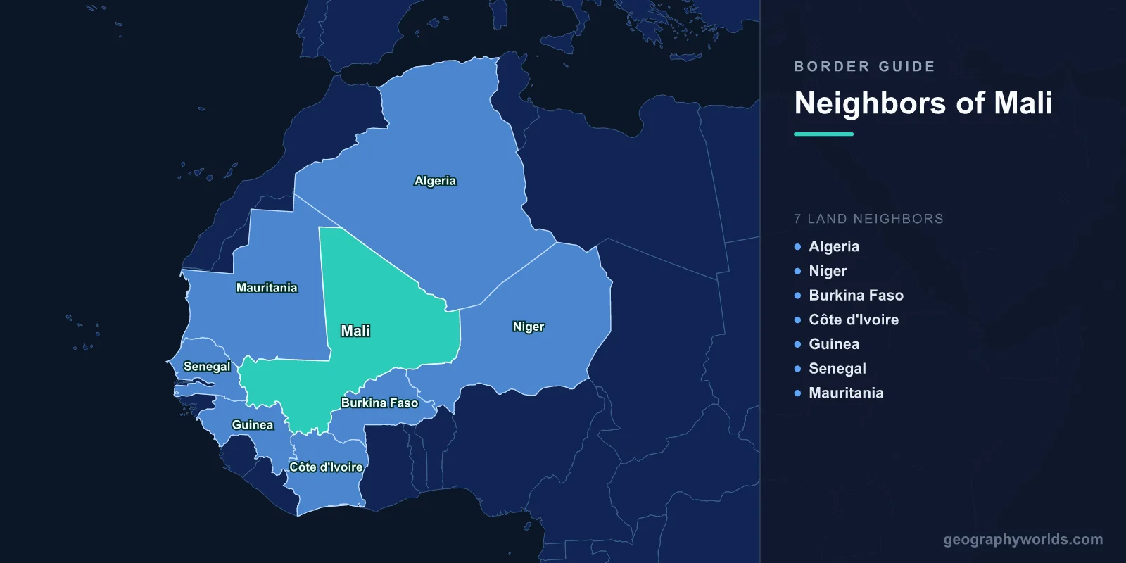
Mali shares land borders with seven countries: Algeria to the north, Niger to the east, Burkina Faso and Ivory Coast to the south, and Guinea, Senegal and Mauritania to the west. It is landlocked, it is the eighth-largest country in Africa, and more than half of it is Sahara. The borders run roughly 7,900 kilometres in total, and almost all of them were drawn inside a single colonial federation, French West Africa, which is why so many of them are straight.
Lines Drawn Inside One Empire
Five of Mali's seven neighbours — Niger, Burkina Faso, Ivory Coast, Guinea, Senegal and Mauritania, six in fact — were part of French West Africa, and the boundaries between them began as administrative divisions within a single colonial state rather than as frontiers between rivals.
That has two consequences. The lines were redrawn repeatedly for administrative convenience, sometimes without survey, which left considerable ambiguity when they became international in 1960. And they cut through peoples — Fulani, Songhai, Soninke, Tuareg, Bambara — whose networks had never been organised around them.
The Organisation of African Unity's 1964 resolution committing members to respect inherited colonial boundaries was intended to prevent the resulting ambiguity from producing wars. In Mali's case it did not entirely succeed.
The Agacher Strip
Mali and Burkina Faso — then Upper Volta — fought over a band of territory in the north-east of Burkina Faso known as the Agacher Strip, roughly 160 kilometres long, thinly populated, with pasture and water points and rumoured minerals that were never confirmed.
There was fighting in 1974 and again in December 1985, when a dispute reportedly sparked by a census enumeration escalated into a five-day war. Aircraft were used, a market town was bombed, and something over a hundred people were killed before mediation ended it.
The two governments then did something unusual: they had already jointly referred the dispute to the International Court of Justice in 1983, and they let the case proceed. The chamber's judgment in December 1986 divided the disputed zone into almost exactly equal halves.
Why That Judgment Is Still Cited
The Burkina Faso v Mali ruling is one of the most cited cases in the law of territory, because it gave the clearest statement of uti possidetis juris — the principle that new states inherit the administrative boundaries of the colonial units they replaced.
The court treated the principle as a general one applicable beyond Latin America, where it originated, and grounded it in the need to prevent the independence of African states from being accompanied by a scramble for territory. Both parties complied with the judgment and demarcated the line, which is the part that makes it worth citing.
The Algerian Border and the Desert Trade
The northern frontier with Algeria runs about 1,350 kilometres through the Sahara, from the Mauritanian tripoint to the Nigerien one, crossing the Tanezrouft and skirting the Adrar des Ifoghas massif.
Algeria has been the most consequential external actor in northern Mali for decades, mediating successive Tuareg rebellions — the agreements of 1991, 2006 and the Algiers Accord of 2015 were all brokered there. It has also kept its border closed to Malian military cooperation with outside forces, and has resisted foreign intervention on its southern flank.
The Adrar des Ifoghas, a maze of granite and ravines straddling the frontier zone, has served as a refuge for armed groups through every one of those conflicts, and French forces fought a difficult campaign there in 2013.
2012, and the Border That Appeared
In early 2012 a Tuareg rebellion, strengthened by fighters and weapons returning from Libya, took the three northern regions of Kidal, Gao and Timbuktu. The National Movement for the Liberation of Azawad declared an independent state covering roughly two-thirds of Mali's territory.
The declaration was recognised by nobody, and within months the movement had been pushed aside by Islamist groups. But for a period Mali was effectively partitioned along a line running east to west near Douentza, and the reconquest in 2013 required French military intervention.
The northern regions have never been fully reintegrated. The 2015 Algiers Accord set out a framework for decentralisation that was implemented slowly and eventually abandoned, and Kidal in particular functioned for years as a territory the central state did not enter.
Timbuktu Sat on a Frontier Long Before This
The border logic of northern Mali is much older than the colonial lines. Timbuktu, Gao and Djenné grew where the Sahara meets the Niger river, at the point where camel caravans transferred their loads to boats — the physical frontier between the desert economy and the river economy.
Salt came south from the mines at Taoudenni, gold came north from the forest kingdoms, and the towns in between taxed the exchange and grew rich enough to support a scholarly culture whose manuscript libraries survive. Every empire that mattered in the region — Ghana, Mali, Songhai — was built on controlling that transfer point rather than on holding a boundary.
Senegal, Mauritania and the Route West
Mali's western borders carry its trade. The Dakar-Bamako railway, built under colonial rule, was for a long time the country's main link to a port, and the road route to Dakar remains important, along with the corridor south to Abidjan.
The Mauritanian border runs through the western Sahara fringe and the Hodh region and is largely empty, but it has become a refugee route: tens of thousands of Malians, mostly Fulani and Tuareg, have crossed into the Mbera camp in south-eastern Mauritania since 2012, and numbers rose again with each escalation.
Relations with Mauritania have been strained by incidents in the border zone, including the reported killings of Mauritanian traders inside Mali, which produced formal protests and a hardening of the line.
Guinea, and the River's Source
The south-western border with Guinea runs through the Fouta Djallon foothills. This matters hydrologically: the Niger river rises in the Guinean highlands only a couple of hundred kilometres from the Atlantic and then turns inland, running north-east into Mali before arcing back south through Niger and Nigeria.
The result is that Mali's most important waterway, the basis of the inner Niger delta and of the irrigated rice production of the Office du Niger, depends on rainfall in a neighbouring country. Guinea's borders hold the headwaters of several West African rivers, which is why it is sometimes called the region's water tower.
Ivory Coast and the Road to the Sea
The southern border with Ivory Coast is short but carries a large share of Malian trade, since Abidjan has been the country's principal port for decades and the rail and road corridor north from it is the main artery.
That dependence makes Malian politics sensitive to Ivorian politics. The Ivorian civil war disrupted the corridor severely in the 2000s, and the arrest of 49 Ivorian soldiers in Bamako in 2022 produced a diplomatic crisis that threatened it again before Togolese mediation resolved the matter.
The Three Borders Zone
Where Mali, Burkina Faso and Niger meet, in the Liptako-Gourma region, is the epicentre of the Sahel insurgency. Armed groups move freely between the three jurisdictions, and the violence has displaced millions across the region.
In 2023 the three states, all then under military governments, formed the Alliance of Sahel States and subsequently announced their departure from ECOWAS, which had imposed sanctions after successive coups. Mali also ended the French military presence and the United Nations mission and brought in Russian forces.
The practical effect on the borders has been to make them harder rather than softer: ECOWAS free movement no longer applies in the same way, and a region whose economies were built on unimpeded cross-border trade now has customs frontiers where it did not.
The Inner Delta, and a Frontier Between Ways of Life
In the middle of Mali the Niger river spreads into the inner delta, a seasonal floodplain covering some 30,000 square kilometres in a country that is mostly desert. It is one of the most productive wetlands in Africa and supports an intricate arrangement between three groups: Bozo fishers, Fulani herders and Bambara and Marka farmers, each with rights to the same ground at different points in the flood cycle.
The system was codified in the nineteenth century under the Dina of the Macina empire, which allocated grazing routes and crossing points and set the order in which herds could enter the floodplain. The annual crossing of cattle at Diafarabé remains a fixed event, with herders returning from months of pasture to the north.
That arrangement has come under severe strain. Reduced flooding, upstream irrigation withdrawals and population growth have compressed the resource, and since 2015 armed groups have inserted themselves into the resulting disputes, recruiting along communal lines. The massacres in Mopti region that followed — at Ogossagou and elsewhere — grew out of a resource conflict that older institutions had managed for two centuries. It is a reminder that the most consequential boundaries in Mali are not always the international ones.
Seven Neighbours, and the Sea That Is Not There
Mali's fundamental geographic condition is that it is very large, very dry and has no coast, so every border is a potential lifeline and every one can be closed. The 2022 ECOWAS sanctions demonstrated this when neighbours shut their frontiers and Bamako's supply chains seized up within weeks.
What kept the country supplied was the one border ECOWAS could not close — the Mauritanian one, since Mauritania is not a member — and Nouakchott's port took on a role nobody had planned for it. Mali more broadly is covered in our Mali country guide, and our Niger river guide follows the waterway that makes the southern half of the country habitable.
