

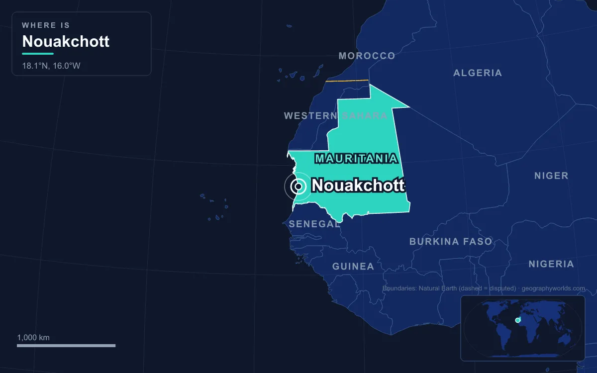
Nouakchott is the capital and largest city of Mauritania, spread across flat sand on the Atlantic coast of the Sahara in the south-west of the country. Around 1.5 million people lived there in 2023, roughly a third of all Mauritanians, which makes it one of the largest cities anywhere in the Sahara. What sets it apart from almost every other African capital is its age: until 1958 it was a small fishing village, a fortified ksar in earlier times, and construction of a planned administrative town for 15,000 people began only in March 1958. Everything since then, from the grid of avenues to the sprawling outer districts, has happened within a single human lifetime.
Before 1958: A Ksar Between Saint-Louis and Nouadhibou
For most of its existence the settlement was a ksar, a small fortified village by the sea whose people lived mostly from fishing the Atlantic. Under French rule, which began to spread north from the Senegal River in the early 1900s, it remained a minor place. Mauritania became part of French West Africa in 1904, but the colony had no capital of its own on its own soil. It was run from Saint-Louis, across the border in what is now Senegal, and after 1902 the federation as a whole was governed from Dakar. During the colonial period around 90 percent of Mauritanians were still nomadic, so there was little urban life for a capital to grow out of.
That absence became a practical problem in the late 1950s. As France moved its West African territories towards independence, Mauritania needed a seat of government inside its own borders. The territory’s new leaders wanted a capital that stood for the whole nation rather than for any one region, which ruled out the existing towns of the interior.
1957–1960: Moktar Ould Daddah Picks a Village on the Dunes
The site was chosen by Moktar Ould Daddah, a lawyer from Boutilimit who became the territory's first prime minister in 1957 and later its first president, together with his advisers. Wikipedia's account of the decision gives three reasons. The village sat roughly midway along the coast between Saint-Louis and Nouadhibou, the port in the far north. Building from almost nothing matched Ould Daddah's wish for a capital that stood for modernity and national unity rather than for any existing power centre. And a coastal site avoided the sensitive question of whether the capital should lie in land dominated by Arab and Berber (Amazigh) Moors or by the Black African communities of the Senegal River valley.
The land had its own inhabitants, the Bouhoubainy, a group of Amazigh origin, who were later moved to other settlements such as Aknodert, between the city and the airport. Construction began in March 1958 with a target population of 15,000. The planners assumed that Nouakchott would be a government town, and that commerce would happen elsewhere. The basic buildings were finished in time for independence on 28 November 1960, when the Islamic Republic of Mauritania was proclaimed with Ould Daddah at its head.
1960–1978: Avenues, Ministries and the Cinquième
The new centre was laid out on a grid of broad streets. Its spine, Avenue Gamal Abdel Nasser, still runs north-east through the middle of the city from the old airport, dividing the residential districts to the north from the medina quarter to the south. Other main roads were named for figures who dominated the headlines of the 1960s: Avenue Charles de Gaulle, Avenue Kennedy and Avenue Lumumba. In the 1960s the city gained its own local government, and in 1973 it was split into four departments.

The plan to keep trade out of the capital failed almost at once. A new district, the Cinquième (Fifth District), grew up close to the administrative core and within a few years held a large open-air market and dense housing. It survives today as Sebkha, the moughataa best known for its shopping streets. By the 1970s these newer quarters, with the ministries and state enterprises, had overtaken the old ksar as the real centre of the city. The capital was also caught up in the Western Sahara War that followed Spain's withdrawal from the territory in 1975. The Polisario Front, fighting both Morocco and Mauritania over Western Sahara, raided Nouakchott twice in 1976. The attacks caused little damage, but El Ouali, the Polisario leader, was killed on 9 June 1976 while his fighters were retreating from the second raid. The war drained Mauritania's finances, and on 10 July 1978 a bloodless coup led by Colonel Mustafa Ould Salek removed Ould Daddah; reports from the capital at the time said no shots were heard in the city.
1969–1990: Drought, Migration and the Kebbe
The single biggest force in Nouakchott's history has been climate rather than politics. The Sahel droughts, most severe between 1969 and 1974, killed livestock and wiped out the pastures that supported nomadic families across the interior. Hundreds of thousands of people moved to the capital, many of them herding families from the interior. A city built for 15,000 had about 20,000 residents in 1969; the census of 1977 counted 134,000 and that of 1988 counted 393,325, and both figures are thought to be below the true number. By the mid-1980s estimates ranged from 400,000 to 500,000.
Most newcomers settled wherever they could. The best known of these settlements is the kebbe, a shanty town that grew up alongside the medina quarter on the southern side of Avenue Gamal Abdel Nasser. Some residents raised cement buildings overnight so that they would look permanent and be harder for the authorities to clear. As late as 1999 more than half of the city's people were estimated to live in tents and shacks, which often served as shops and workshops as well as homes. Part of the population stayed semi-nomadic, pitching tents in one spot and moving on when conditions changed, which is one reason population counts for Nouakchott disagree so widely. In 1986 the four departments of 1973 became nine, the division that still exists: Teyarett, Ksar, Tevragh-Zeina, Toujounine, Sebkha, El Mina, Dar-Naïm, Arafat and Riyad.
1986–2008: Friendship Port, Coups and a Capital Region
Nouakchott's economy changed when it gained a real harbour. The coastline is a strip of sandbanks, beaches and even patches of quicksand near the harbour, so a deepwater port had to be built from scratch. The Chinese-built Friendship Port opened in 1986 with a design capacity of 500,000 tonnes of cargo a year; by 2009 it was handling about 1.5 million tonnes, and China agreed that year to invest US$282 million in lengthening the main quay by more than 900 metres. Road links followed. The Route de l'Espoir (Road of Hope) runs about 1,100 kilometres inland to Néma, and the coastal highway north to Nouadhibou was paved in 2004, giving the capital an asphalt link to the other end of the country.
Politically, the city remained the stage for changes of power decided by the army. Maaouya Ould Sid'Ahmed Taya took over in a bloodless coup in December 1984 and ruled for 21 years, until officers removed him on 3 August 2005 while he was in Saudi Arabia for King Fahd's funeral. Elections in March 2007 brought in Sidi Ould Cheikh Abdallahi, who was deposed on 6 August 2008 by generals he had dismissed that same morning. In 1990 Nouakchott, previously a district, was made a region of Mauritania in its own right.

Fishing, the activity that defined the old ksar, never went away. One stretch of beach is still given over to the pirogues, and fish can be bought straight off the boats at the market beside it, a short drive from ministries built on land that was open dune in 1957.
2009–Today: Resettlement, Oumtounsy and Three Wilayas
In 2009 the government announced that about 24,000 families living in the outer shanty districts would be moved to planned housing, starting with 9,000 families bound for a part of Arafat nicknamed "Kosovo" for its crime and poor services. Aid agencies warned that the receiving areas lacked infrastructure, but the World Bank later judged the programme largely successful, reporting that 181,035 people in former slum areas gained access to improved services. The 2013 census counted 958,399 residents, and estimates put the figure at around 1.5 million by 2023.
On 25 November 2014 the capital region was split into three wilayas: Nouakchott-Nord (Dar-Naïm, Teyarett, Toujounine), Nouakchott-Ouest (Ksar, Sebkha, Tevragh-Zeina) and Nouakchott-Sud (Arafat, El Mina, Riyad). A directly elected regional council was added in 2018, and Fatimatou Abdel Malick, elected its president that September, was re-elected in May 2023. In June 2016 the city's air traffic moved to the new Nouakchott–Oumtounsy International Airport, 25 kilometres north of the centre, opened in time for the Arab League summit hosted by Mauritania that July. The presidential election of 2019, won by Mohamed Ould Ghazouani, was presented as the country's first peaceful transfer of power since independence, and he won re-election in June 2024.
The environment remains the city's biggest long-term problem. Nouakchott is almost entirely flat, some districts lie below sea level, and most buildings have a single storey, so the city sprawls far across the sand. Dunes advance on it from the east, while low-lying coastal land floods from the west. Average rainfall is only about 95 millimetres a year, highs hover around 33°C for most of the year, and September and October, not midsummer, are the hottest months. A 2019 study estimated that under a moderate warming scenario the city's climate in 2050 would most resemble today's Khartoum. The Sheikh Zayed solar plant, completed in 2012, was built partly to meet a projected 450 percent rise in electricity demand between 2010 and 2030.
A town planned for 15,000 now holds a third of a nation, and it still depends on the same sea and the same sand that shaped the village. To see how the capital fits into the country around it, continue with our Mauritania country guide, or read how the wider geography of the Sahara keeps pressing on cities built at its edge.
Quick Facts About Nouakchott
- Country: Mauritania
- Continent: Africa (West Africa)
- Country population: approximately 5.5 million
- Capital city status: Nouakchott is the capital of Mauritania, the seat of national government, and the location of foreign embassies, parliament, and the head of state's official residence.
Frequently Asked Questions
What is the capital of Mauritania?
The capital of Mauritania is Nouakchott. Nouakchott is the seat of national government, hosts most foreign embassies and consulates, and is typically where the head of state and parliament are located.
What continent is Nouakchott in?
Nouakchott, the capital of Mauritania, is located in Africa, in the West Africa region. As Mauritania's capital, Nouakchott serves as the country's primary connection to the broader African political, economic, and cultural sphere.
Why is Nouakchott the capital of Mauritania?
Nouakchott was chosen as the capital of Mauritania for reasons that typically combine geography, history, and politics. Capital city selections often reflect a desire for centrality (being accessible from across the country), historical importance (being a longstanding seat of government or culture), or neutrality (being acceptable to multiple regions or ethnic groups within the country). The specific reasons for Nouakchott's designation are detailed in the city's history above.
What is Nouakchott known for?
As the capital of Mauritania, Nouakchott is best known for housing the country's central government institutions — parliament, presidential or royal residences, supreme court, and key ministries. It is also typically a major cultural and economic center within Mauritania, hosting national museums, embassies, and signature monuments. The introduction and history sections above provide detailed coverage of the city's specific notable institutions and landmarks.
Related Pages
- Mauritania Country Guide — full geography, climate, economy, and culture overview
- Flag of Mauritania — meaning, history, and design of Mauritania's national flag