

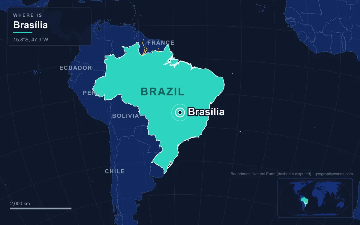
Brasília is the capital of Brazil, a planned city on the Brazilian Highlands in the country’s Central-West region, about 1,000 metres above sea level. It was inaugurated on 21 April 1960 to replace Rio de Janeiro, and the 2022 census counted 2,817,381 people in the Federal District that IBGE, Brazil’s statistics agency, treats as the city, making it Brazil’s third-most populous city after São Paulo and Rio. Its airplane-shaped core by Lúcio Costa and Oscar Niemeyer is a UNESCO World Heritage Site, but the city that grew around that core was made by people nobody drew into the plan: construction workers, northeastern migrants, transferred civil servants, diplomats and their teenage children.
From the 1891 Constitution to Novacap
The idea was old. Brazil’s 1891 constitution reserved 14,400 square kilometres on the central plateau for a future capital, and the Belgian astronomer Luís Cruls surveyed the site in expeditions of 1892 and 1894. A foundation stone went up in 1922 for the centenary of independence. Nothing more happened until Juscelino Kubitschek, elected president in 1955 on a promise of fifty years of progress in five, took office in January 1956 and made the new capital the centrepiece of his programme. In 1957 an international jury chose Lúcio Costa’s pilot plan, backed by five of its six members, and the state company Novacap, short for Nova Capital, ran the works from a camp that was later nicknamed Velhacap, the old capital.
The Candangos: 30,000 Workers in 41 Months
The labour came from across the country. The workers who built Brasília were called candangos, and they arrived from every region, though most came from Brazil’s Northeast. Roughly 30,000 of them, working day and night with more than 200 machines, raised the city in 41 months, pouring the concrete for Niemeyer’s ministries and palaces on land that had been open cerrado savanna. The deadline of 21 April 1960 was a homage to the Inconfidência Mineira: it was the anniversary of the hanging in 1792 of Tiradentes, leader of that independence plot and now a national hero.

The workers are commemorated in the heart of the capital. Bruno Giorgi’s bronze of two elongated figures, completed in 1959, stands in front of the Palácio do Planalto on the Square of the Three Powers and is popularly called Os Candangos. The name is also written into the map: Candangolândia, literally the land of the candangos, began as a workers’ settlement founded on 3 November 1956 and is now an administrative region of about 16,000 people. Some of the earliest workers’ housing did not survive. Vila Amaury, a village where the first construction crews lived, was flooded when the artificial Lake Paranoá filled, and divers can now visit its remains on the lake bed.
Núcleo Bandeirante and Taguatinga, the First Towns Outside the Plan
Costa’s Plano Piloto was designed for government, not for the people building it. So the workers made their own town. Work camps multiplied as migrants poured in, with food served in mess halls and workers sleeping in barrack-like housing, and many became permanent towns. The Núcleo Bandeirante settlement, founded on 19 December 1956, is one of them. It still exists as one of the Federal District’s administrative regions, just west of Lake Paranoá.
Taguatinga followed. It was founded on 5 June 1958, two years before the inauguration, and was first called Vila Sarah Kubitschek after the president’s wife. Locals shorten it to Taguá. Its first residents were working in local schools, hospitals and shops within months, and it grew into one of the district’s main commercial centres, with large shopping centres drawing people from nearby towns. With 222,598 inhabitants it is now the fourth-largest administrative region and is often called the economic capital of the Federal District. Ceilândia, Samambaia, Águas Claras and Vicente Pires were all carved out of Taguatinga’s original territory.
This was the pattern that would define Brasília. The planned city stayed small and orderly, and most of the people who served it lived in satellite towns outside it, reached by buses from the central bus station and, much later, by a metro built mainly for satellite-town residents.
Northeastern Migrants and the Fairs of Ceilândia
Within a decade the satellite towns could not keep up. In 1969, only nine years after the inauguration, 79,128 people in the Federal District were living in irregular settlements, out of a total population of around 500,000. The district government under Hélio Prates da Silveira responded with the Campanha de Erradicação de Invasões, the Invasions Eradication Campaign, known by its initials CEI. It laid out 17,619 plots on open land to the west, and families were moved there in nine months, arriving to find no running water, no street lighting and no buses. The settlement was founded on 27 March 1971 and named Ceilândia, from CEI plus the suffix -lândia.
Ceilândia is now the largest administrative region in the Federal District, with about 398,374 people, far more than the Plano Piloto. About 70 percent of its population is of northeastern origin, and it is described as the second-largest northeastern city outside the Northeast, after São Paulo. The culture shows in its 13 open-air markets. The wholesale Feira do Produtor supplies close to half the Federal District’s produce, and the Feira Permanente covers 7,000 square metres. Niemeyer himself designed the Casa do Cantador, completed in 1986, a cultural centre dedicated to the singers and poets of Northeast Brazil.
Civil Servants in the Superquadras of the Plano Piloto
Costa’s answer to how the capital’s own staff would live was the superquadra. The Residential Axis, the curved wings of the airplane, was laid out as 96 superblocks limited to six-storey buildings plus 12 more limited to three storeys, each ringed by trees and served by its own local shops, schools and churches. Costa wanted apartments of two or three standard categories in the same block, so that upper- and middle-class families would share a neighbourhood, and he planned separate housing for the working classes to stop favelas forming at the edge of the city.
The wings were built for the staff of a city conceived as the seat of the ministries, Congress and the courts that had until then sat in Rio de Janeiro. The old federal capital did not vanish; the former Federal District around Rio became the state of Guanabara in 1960 and merged into Rio de Janeiro state in 1975. The planners expected the Plano Piloto to reach about 500,000 inhabitants. It never has: its population is put at just 214,529, a fraction of the district total. The superquadras remain green and quiet, a contrast sharp enough that critics nicknamed the core ilha da fantasia, fantasy island, compared with the poorer towns of Goiás and Minas Gerais that surround the district.

Diplomats, Legião Urbana and the Coca-Cola Generation
A capital also imports a foreign community. Brasília hosts around 124 foreign embassies, many of them in a dedicated Embassy Sector, and it is the seat of all three branches of government. The planned city of officials also produced something nobody had planned: a generation of young musicians who turned it into a rock city.
Brasília is often called the birthplace of Brazilian rock. Renato Russo’s band Aborto Elétrico split after arguments with brothers Fê and Flávio Lemos, who went on to form Capital Inicial, while Russo founded Legião Urbana in 1982. Its first album, released in 1985, included Geração Coca-Cola (Coca-Cola Generation), and the band became one of the most influential in Brazilian music history before Russo’s death in 1996. Plebe Rude and later Raimundos came out of the same scene. The city’s cultural calendar reflects its other communities too: festas juninas in June honour Saint Anthony, Saint John and Saint Peter, the Independence Day parade fills the Esplanada every 7 September, and the Brasília Festival of Brazilian Cinema, held since 1965, still accepts only Brazilian films.
2,817,381 People: Who Lives in Brasília Today
At the close of the 20th century Brasília was the largest city in the world that had not existed at its start. Its growth has been driven by internal migration, with an annual rate recorded at 2.82 percent, among the highest in Brazil. The 2022 census counted 1,370,836 people of mixed race (48.7 percent), 1,126,334 White (40 percent), 301,765 Black (10.7 percent), 12,810 Asian and 5,536 Indigenous residents. The Federal District has no mayor or city council, because Article 32 of the Constitution bars it from being divided into municipalities; it is governed instead as 35 administrative regions under a governor and a 24-member Legislative Chamber.
Its economy still reflects why people came. Public administration accounts for about 54.8 percent of local GDP, services for 28.7 percent and industry for 10.2 percent, and the district has the highest GDP per capita of any Brazilian federal unit. The result is a city of two halves: Niemeyer’s white monuments along the Eixo Monumental, which closes to cars on Sundays and holidays so families can walk, cycle and picnic on it, and the satellite towns where most of the population actually lives. UNESCO protects the first half as a World Heritage Site, inscribed in 1987, and in October 2017 named Brasília a City of Design.
Brasília belongs to a small group of capitals built from scratch, alongside Canberra and Abuja; see how they compare in our guide to planned cities around the world. For the plateau it stands on, read about the geography of the Brazilian Highlands, and to set it against Brazil’s other seats of government, browse our list of Brazil’s 26 state capitals.
Quick Facts About Brasilia
- Country: Brazil
- Continent: South America
- Country population: approximately 213.6 million
- Capital city status: Brasilia is the capital of Brazil, the seat of national government, and the location of foreign embassies, parliament, and the head of state's official residence.
Frequently Asked Questions
What is the capital of Brazil?
The capital of Brazil is Brasilia. Brasilia is the seat of national government, hosts most foreign embassies and consulates, and is typically where the head of state and parliament are located.
What continent is Brasilia in?
Brasilia, the capital of Brazil, is located in South America. As Brazil's capital, Brasilia serves as the country's primary connection to the broader South American political, economic, and cultural sphere.
Why is Brasilia the capital of Brazil?
Brasilia was chosen as the capital of Brazil for reasons that typically combine geography, history, and politics. Capital city selections often reflect a desire for centrality (being accessible from across the country), historical importance (being a longstanding seat of government or culture), or neutrality (being acceptable to multiple regions or ethnic groups within the country). The specific reasons for Brasilia's designation are detailed in the city's history above.
What is Brasilia known for?
As the capital of Brazil, Brasilia is best known for housing the country's central government institutions — parliament, presidential or royal residences, supreme court, and key ministries. It is also typically a major cultural and economic center within Brazil, hosting national museums, embassies, and signature monuments. The introduction and history sections above provide detailed coverage of the city's specific notable institutions and landmarks.
Related Pages
- Brazil Country Guide — full geography, climate, economy, and culture overview
- Flag of Brazil — meaning, history, and design of Brazil's national flag