

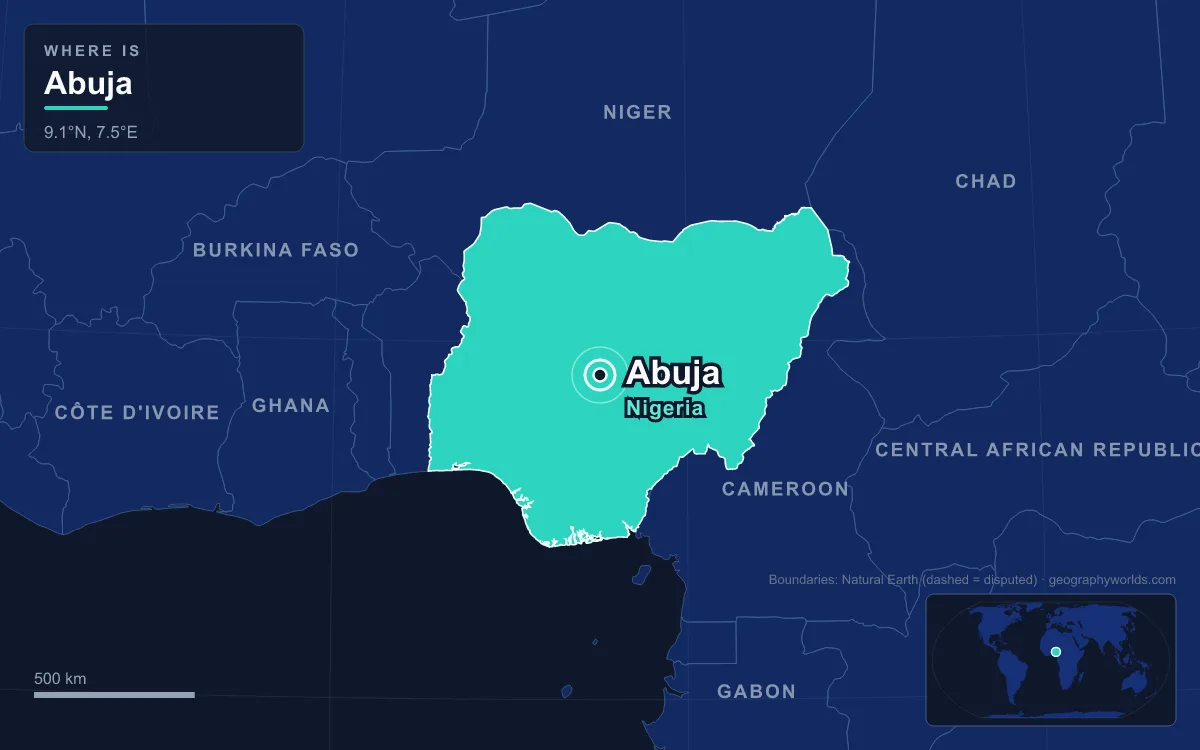
Abuja is the capital of Nigeria. It sits almost exactly in the middle of the country, inside the Federal Capital Territory (FCT), and it took over from the coastal city of Lagos on 12 December 1991. The 2006 census counted 776,298 people in the city proper, and the wider urban area was estimated at about 3.77 million in 2022. What sets Abuja apart is that it was planned and built from scratch in the 1980s as a deliberately neutral capital. Its government district is laid out beneath Aso Rock, a granite monolith that rises about 400 metres above the surrounding land.
Before 1976: Gbagyi Villages and the Town That Lent Its Name
The capital's site was not empty before the planners came. The central Nigerian savanna here was mostly Gbagyi (Gwari) country, and the Gwandara, Koro, Bassa, Nupe and Ganagana peoples also lived in the area. Place names that now belong to upmarket districts, such as Asokoro, Wuse, Karshi and Nyanya, started out as villages or settlements. When the federal government took over the land it counted about 120,000 residents living in roughly 840 villages. Many of them were moved out to towns like Suleja in Niger State and New Karshi in Nasarawa State.
The name itself came from somewhere else. In the early twentieth century "Abuja" meant a town just north of today's capital. That town was founded in the early 1800s by Mohammed Makau, the last Hausa emir of Zaria, and his followers, who were escaping the Fulani jihad. When the new federal capital took the name in 1976, the old town was renamed Suleja after its then emir, Sulayman Bal. Visitors still mix the two up today. Zuma Rock, a gabbro and granodiorite inselberg that rises to about 725 metres above sea level and appears on the 100 naira note, stands beside the Kaduna road near Suleja. It is often called the gateway to Abuja, although it actually lies just outside the FCT in Niger State.
1976–1979: Decree No. 6 and a Capital Drawn on Paper
After independence in 1960, Lagos did two jobs as Nigeria's capital and its biggest port, and it was struggling with both. The city was overcrowded, living conditions were squalid and there was little room left to grow. Politics mattered too. Lagos was a Yoruba city in the south-west, in a federation divided between a largely Muslim north and a largely Christian south, with three dominant ethnic groups. Planners wanted a capital that no single group could claim as its own. They chose a site near the centre of the country, a little north of where the Niger and Benue rivers meet. People compared the idea to Brazil's move inland to Brasília.
The military government of General Murtala Mohammed made the decision after a panel led by Justice Akinola Aguda recommended the site. Decree No. 6, promulgated on 4 February 1976, created the Federal Capital Territory and gave the federal government rights over all land inside it. Nine days later Murtala was assassinated in a failed coup, and his successor, Olusegun Obasanjo, carried the plan forward. The territory covers about 7,315 square kilometres. It was taken mostly from Niger State, with smaller pieces from the old Kaduna, Kwara and Plateau states. The chart below shows how long its borders with each neighbouring state are.
In June 1977 the new Federal Capital Development Authority (FCDA) hired International Planning Associates to draw up a master plan. This was a consortium led by the American firm Wallace, Roberts, McHarg & Todd. After 18 months of work, the final report went to the FCDA's first executive secretary, Abubakar Koko, on 15 February 1979. It set out the concentric structure Abuja still has. The inner Phase 1 districts (Central Area, Maitama, Asokoro, Wuse and Garki) spread out from the foot of Aso Rock, and outer phases are divided from one another by expressways. The Japanese architect Kenzo Tange and his firm Urtec then designed the monumental core and the Central Business District in more detail.
1979–1991: Aso Rock, Awolowo's Jibe and a Slow Build
Construction started in 1979 under President Shehu Shagari, whose civilian government laid the first foundations. Not everyone supported the move. Obafemi Awolowo, the leading Yoruba politician of the time, opposed leaving Lagos. During the fierce 1979 presidential campaign he promised that if he won, he would hire the Walt Disney Company to turn the site into an amusement park. Shagari won instead. His first trip out of Lagos after the election was to the building site, but he was frustrated by how slowly work was going, and he pushed the target date for relocation back from 1986 to 1992.

Money was short and politics were unsettled, including a military coup at the end of 1983, so the first stages were not finished until the late 1980s. Still, the city's shape was clear by then, and Aso Rock was at its centre. The rock peaks at 936 metres above sea level and stands about 400 metres above the plain. Its name is usually explained as meaning "victorious" in the language of the Asokoro people. The planners put the Three Arms Zone (the presidency, the legislature and the judiciary) at its base, so the rock serves as a natural backdrop to the state. One landmark finished early was the Abuja National Mosque on Independence Avenue, built in 1984. Its golden dome and four minarets were among the first sights in the new city skyline.
12 December 1991: Babangida's Government Moves Inland
The move finally happened under the military ruler Ibrahim Babangida. On 12 December 1991 Abuja officially became the seat of the federal government. That same year Babangida's administration founded Aso Villa, the presidential residence at the foot of the rock. That is why "Aso Rock" is used in Nigerian speech to mean the presidency itself. Foreign governments followed over the years. Most moved their embassies to Abuja and kept their old Lagos missions as consulates, since Lagos stayed the country's commercial centre.
Regional institutions came to the new capital as well. Abuja is the headquarters of the Economic Community of West African States (ECOWAS), and the ECOWAS secretariat is a landmark in Asokoro. Asokoro is the most exclusive and most secure district in the city. Most cabinet ministers live there, along with much of the diplomatic community. Garki, in the south-west corner of the city, became the busy administrative district. It is divided into numbered "Areas" 1 to 11, a system that visitors often find confusing.
1999–2010: Eagle Square, Demolitions and Record Growth
On 29 May 1999 Nigeria returned to civilian rule, and Olusegun Obasanjo was sworn in again, this time as an elected president. The ceremony took place in Eagle Square in the Central District, and every presidential inauguration since then has been held there too. Across Shehu Shagari Way from the square is the Tomb of the Unknown Soldier, which is the focus of Armed Forces Remembrance Day every 15 January. In 2003 Abuja hosted the Commonwealth Heads of Government Meeting. The leaders' Aso Rock Declaration made democracy and development the Commonwealth's priorities.

The planners' goal of religious balance showed up in stone on Independence Avenue. Opposite the mosque, the National Christian Centre was dedicated on 2 October 2005, on Nigeria's 45th independence anniversary. Work on it had begun around 1989 and then stalled until the Christian Association of Nigeria restarted it in 2004. The church was designed by the Lagos firm Darchiwork Group in a postmodern take on the neo-Gothic style, and its central altar makes a full turn every ten minutes.
People arrived far faster than the plan had allowed for. United Nations figures show Abuja grew by 139.7 per cent between 2000 and 2010, which made it the fastest-growing city in the world during that decade. Some areas on its edges grew by 20 to 30 per cent a year. Informal settlements spread inside and outside the city limits. In 2003 the FCT minister Nasir el-Rufai began a demolition campaign, and tens of thousands of people have been evicted since then.
2011 to Today: Rail Links, Satellite Towns and a Metropolis
The planned city has now spilled over into its surroundings. Karu, Suleja, Gwagwalada, Lugbe and Kuje have grown into satellite towns that house many of the people who commute into central Abuja. The FCT is still unlike Nigeria's 36 states. Instead of an elected governor, it is run by the Federal Capital Territory Administration, headed by a minister whom the president appoints. The Abuja Municipal Area Council handles local government for the city itself.
Transport has taken years to catch up. The 187-kilometre standard-gauge railway to Kaduna opened in July 2016 as the first completed section of the planned Lagos–Kano line, and its trains leave from Idu station. The Abuja light rail opened in 2018 as the first rapid-transit system in West Africa. It shut in 2020 during the COVID-19 pandemic and did not reopen until 29 May 2024. Most air travel goes through Nnamdi Azikiwe International Airport, which is named after Nigeria's first president. The A2 expressway runs north to Kaduna and south to Lokoja.
The climate is part of the reason the inland site suited a capital. Abuja has a tropical wet and dry climate. Rain falls from April to October, when daytime highs are usually 28 to 30°C. The dry season can reach 40°C, and in between comes the harmattan, bringing dusty haze from the Sahara. Because the city is inland and sits on undulating ground at moderate altitude, the difference between day and night temperatures is much larger than in coastal Lagos. Rainfall is helped by the FCT's position on the windward side of the Jos Plateau.
Abuja also hosts events that come with being a capital. It held the World Economic Forum on Africa in 2014 and joined the UNESCO Global Network of Learning Cities in 2016. It is also the setting for Nigeria's federal politics as a whole. To see how the FCT fits alongside the states it was carved from, read our guide to how many states Nigeria has. For a comparison with the port city Abuja replaced, see our look at the geography of Lagos. Abuja also belongs to a small group of purpose-built capitals, and you can compare it with Brasília, Canberra and others in our guide to planned cities around the world.
Quick Facts About Abuja
- Country: Nigeria
- Continent: Africa (West Africa)
- Country population: approximately 242.4 million
- Capital city status: Abuja is the capital of Nigeria, the seat of national government, and the location of foreign embassies, parliament, and the head of state's official residence.
Frequently Asked Questions
What is the capital of Nigeria?
The capital of Nigeria is Abuja. Abuja is the seat of national government, hosts most foreign embassies and consulates, and is typically where the head of state and parliament are located.
What continent is Abuja in?
Abuja, the capital of Nigeria, is located in Africa, in the West Africa region. As Nigeria's capital, Abuja serves as the country's primary connection to the broader African political, economic, and cultural sphere.
Why is Abuja the capital of Nigeria?
Abuja was chosen as the capital of Nigeria for reasons that typically combine geography, history, and politics. Capital city selections often reflect a desire for centrality (being accessible from across the country), historical importance (being a longstanding seat of government or culture), or neutrality (being acceptable to multiple regions or ethnic groups within the country). The specific reasons for Abuja's designation are detailed in the city's history above.
What is Abuja known for?
As the capital of Nigeria, Abuja is best known for housing the country's central government institutions — parliament, presidential or royal residences, supreme court, and key ministries. It is also typically a major cultural and economic center within Nigeria, hosting national museums, embassies, and signature monuments. The introduction and history sections above provide detailed coverage of the city's specific notable institutions and landmarks.
Related Pages
- Nigeria Country Guide — full geography, climate, economy, and culture overview
- Flag of Nigeria — meaning, history, and design of Nigeria's national flag