
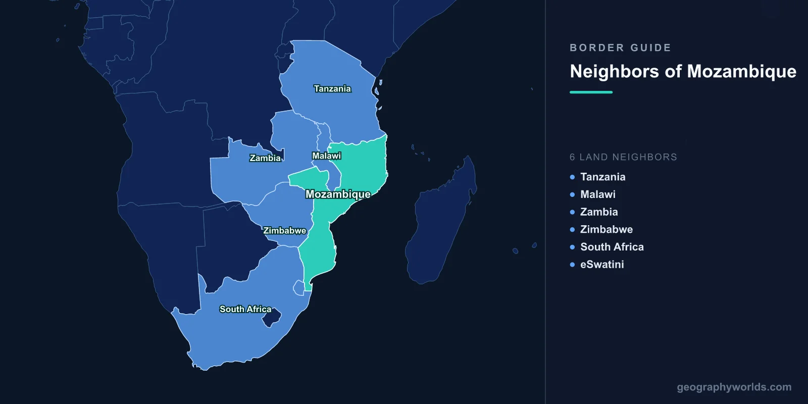
Mozambique shares land borders with six countries: Tanzania to the north, Malawi and Zambia to the north-west, Zimbabwe to the west, and South Africa and Eswatini to the south-west. Four of those six — Malawi, Zambia, Zimbabwe and Eswatini — are landlocked, and for every one of them the nearest ocean is reached by crossing Mozambique. A 2,470-kilometre coastline facing a landlocked interior is the fact from which almost everything else about these borders follows.
A Country Shaped Like a Set of Corridors
Mozambique is long and narrow, curving around the south-eastern edge of the continent, and its economic geography is organised into three transport corridors running inland from three ports.
- The Maputo corridor connects the southern capital to Johannesburg and the Gauteng industrial region, which is closer to Maputo than to any South African port.
- The Beira corridor runs west from the central port of Beira to Zimbabwe, and onward to Zambia and the Copperbelt.
- The Nacala corridor runs from the deep-water northern port of Nacala through Malawi and into Zambia, carrying coal from Tete province and Malawian agricultural exports.
Each corridor is a railway, a road and a pipeline or two, and each exists because of what lies on the other side of a border rather than because of Mozambican demand.
The Border That Wraps Around Malawi
Malawi is almost enclosed by Mozambique. The boundary runs along Malawi's southern, south-eastern and much of its eastern and western flanks, so that Malawi protrudes into Mozambican territory like a finger, with Zambia and Tanzania accounting for the rest.
The practical consequence is that Malawi's trade is at Mozambique's mercy. During the Mozambican civil war of the 1980s, RENAMO attacks on the Nacala and Beira railways cut Malawi off from both, forcing its imports and exports onto a vastly longer road route south through Zimbabwe and South Africa and imposing an economic cost Malawi could barely absorb.
Relations were complicated further by Malawi's position under Hastings Banda, who maintained relations with apartheid South Africa and was accused of permitting RENAMO to operate from Malawian territory. Several hundred thousand Mozambican refugees crossed into Malawi during the war, one of the largest refugee populations in Africa at the time.
Beira, and the Border Mozambique Closed
The most consequential decision Mozambique ever made about a border was to shut one. In 1976, a year after independence, Samora Machel's government closed the frontier with Rhodesia and applied United Nations sanctions against Ian Smith's government, cutting off the landlocked state's principal route to the sea through Beira.
The cost to Mozambique was enormous — the lost transit revenue was a large fraction of national income, and Rhodesia retaliated by supporting the creation of RENAMO, which became the vehicle for a civil war that lasted until 1992 and killed around a million people. When Zimbabwe became independent in 1980, its government sent troops to defend the Beira corridor against the movement Rhodesia had created.
That episode is why Mozambican and Zimbabwean politics have remained closely entangled, and why the corridor is treated in both countries as a strategic asset rather than a commercial one.
Maputo Is South Africa's Nearest Port
The border with South Africa is short by African standards but carries the heaviest traffic. Ressano Garcia, on the road and rail line to Komatipoort, is among the busiest land crossings in southern Africa, handling freight, minibuses and a very large daily flow of Mozambicans working across the line.
Labour migration to South African mines is more than a century old and was formalised in agreements under which a portion of miners' wages was remitted to the Portuguese colonial administration in gold. Mozambican mineworkers remain a significant presence, and remittances are a substantial part of the southern economy.
The Maputo Development Corridor, launched in the 1990s, upgraded the road, rail and port to capture Gauteng's freight, and it works: for exporters in the northern half of South Africa, Maputo is simply closer than Durban or Richards Bay.
Eswatini's Route to the Sea
Eswatini borders Mozambique along a short eastern boundary, and that line is the kingdom's only frontier with a state other than South Africa. For a country otherwise entirely surrounded by one much larger neighbour, the Mozambican border is a strategic alternative, however modest.
The Goba rail line runs from Eswatini to Maputo and has carried sugar and timber exports for decades, offering a route that does not depend on South African infrastructure. The crossing at Lomahasha is small, and the relationship is quiet, but the option itself has value.
The Rovuma, the Gas, and a War That Crossed
The northern boundary with Tanzania follows the Rovuma river for most of its length. It was historically a frontier between German East Africa and Portuguese Mozambique, and the river is wide and difficult enough that crossings have always been few; the Unity Bridge, opened in 2010, was the first permanent road link.
The region became globally significant after enormous offshore natural gas reserves were confirmed in the Rovuma basin in the 2010s, prompting some of the largest energy investments ever committed in Africa.
Then, from 2017, an Islamist insurgency took hold in Cabo Delgado. Fighters attacked Mocímboa da Praia and in 2021 overran Palma, next to the gas project, forcing a suspension of construction. The insurgency drew on grievances on both sides of the river, and attacks and recruitment have crossed into southern Tanzania, which deployed forces and joined a regional response alongside Rwandan and SADC troops.
The Zambian Corner
Zambia's border with Mozambique is the shortest of the six and runs through remote country in the north-west of Tete province, where the two meet near the Malawian and Zimbabwean frontiers.
Its importance is out of proportion to its length because of what passes near it. Tete is Mozambique's coal province, and the Nacala corridor railway that carries that coal to the coast runs through Malawi; Zambian copper has historically reached the sea through Beira. The tangle of short borders in this corner of the continent is why regional transport agreements matter more here than almost anywhere else.
Cahora Bassa, and Power That Crosses Borders
The Zambezi enters Mozambique from Zimbabwe and Zambia and is dammed at Cahora Bassa, completed under Portuguese rule in 1974 and one of the largest hydroelectric schemes in Africa.
It was built to sell power to South Africa, and it still does, through high-voltage lines running south across the border. During the civil war the pylons were a standing target and the line was down for years. Ownership passed from Portugal to Mozambique only in 2007, more than three decades after independence, in a buyout that was treated domestically as a second act of decolonisation.
Prazos, and Borders Before the Colonial Ones
Long before Portugal drew a boundary, the Zambezi valley was organised by the prazo system: vast estates granted to settlers and Afro-Portuguese families who ruled them with private armies of enslaved soldiers called chikunda. Some prazos were larger than European countries and operated as effectively independent states well into the nineteenth century.
Portugal's authority over the interior was in practice a legal fiction until the 1890s, which is exactly why the British Ultimatum of 1890 succeeded so easily. Lisbon's claim to the land between Angola and Mozambique rested on maps rather than on administration, and the effective occupation standard set at Berlin was one it could not meet.
A Park That Ignores the Fence
Along the South African border, the Great Limpopo Transfrontier Park links Kruger National Park with Mozambique's Limpopo National Park and Zimbabwe's Gonarezhou, with sections of the boundary fence removed so that elephants and other wildlife can use ranges that predate the states.
The scheme has had mixed results — relocating people living inside the Mozambican section proved contentious, and the open boundary has complicated anti-poaching work, with rhino poaching syndicates operating across it. It remains the clearest example in the region of a border treated as a line on a map rather than a barrier on the ground.
The Lake That Two Countries Disagree About
Mozambique's boundary with Malawi runs partly through Lake Malawi, known on the Mozambican side as Lake Niassa, and here the two states agree — the line follows the median of the lake, as fixed in the colonial period and accepted since.
That is worth noting because Malawi's other lake boundary is bitterly contested. Malawi claims the entire surface of the lake up to the Tanzanian shoreline, relying on the 1890 Heligoland-Zanzibar Treaty between Britain and Germany, while Tanzania insists on a median line consistent with normal practice. The dispute hardened when hydrocarbon exploration began, and mediation attempts have not resolved it.
Mozambique's position in that argument is quietly consequential: by holding a median-line boundary on its own section, it supplies a precedent that undercuts the Malawian claim further north. The lake also matters ecologically, holding several hundred endemic cichlid species, more freshwater fish species than any other lake on earth, and the Mozambican shore is the least developed and least studied part of it.
Why the Coast Is the Asset
Mozambique's six land borders describe a country that is, in transport terms, the roof over a landlocked region. That position has been a source of leverage, of vulnerability and of war, and it explains why its neighbours have intervened in its internal conflicts so consistently.
It also explains the country's economic strategy, which is essentially to charge for transit and to export what lies offshore. The country beyond these six frontiers is our Mozambique country guide, while our Zambezi guide follows the river that crosses three of these borders before reaching the Indian Ocean here.
