
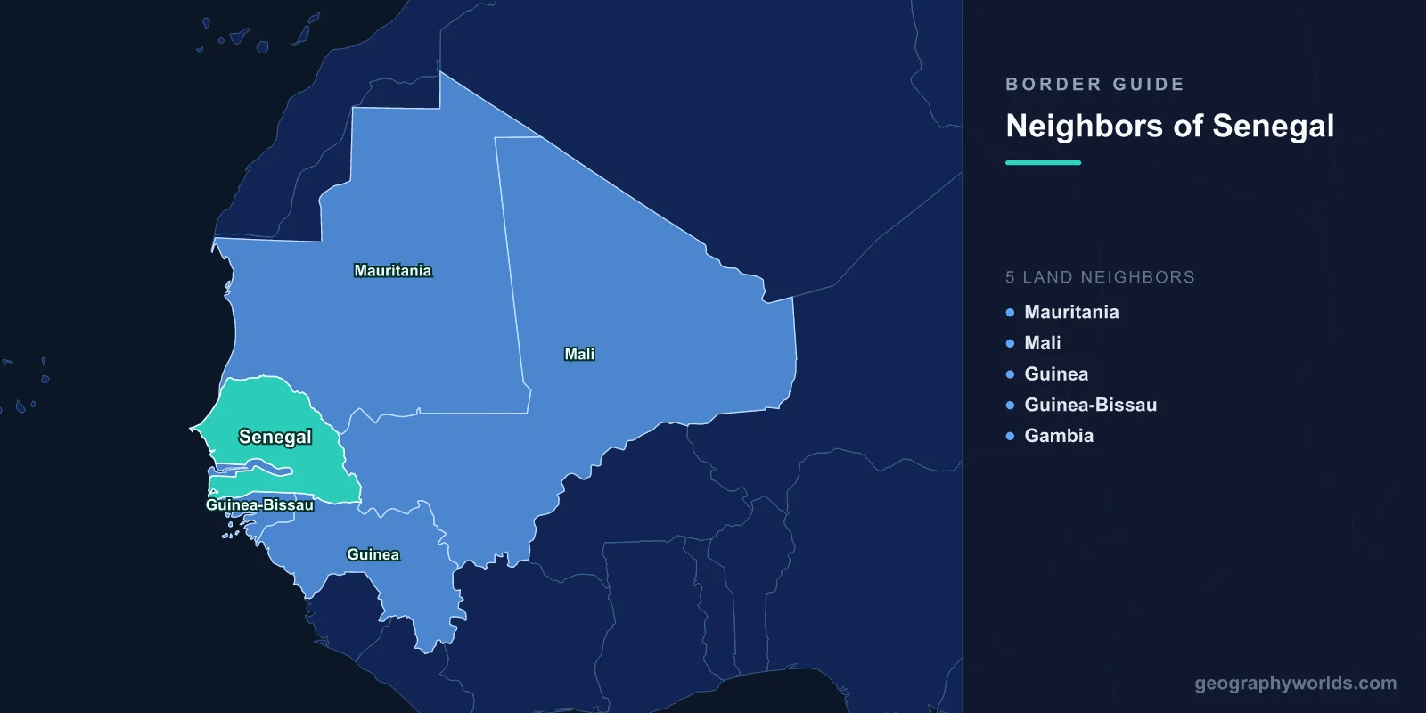
Senegal shares land borders with five countries: Mauritania to the north, Mali to the east, Guinea and Guinea-Bissau to the south, and the Gambia, which is almost entirely enclosed by Senegalese territory. The Atlantic forms the western edge. The Gambian border alone runs about 740 kilometres for a country that is nowhere more than 50 kilometres wide, and that single peculiarity has done more to shape Senegal than any of the other four lines.
A River, a Ruler and a Map
The Gambia exists because Britain held the river and France held everything around it. British traders were established on the Gambia river from the seventeenth century, and when the European powers partitioned the region in the late nineteenth, Britain kept a strip along both banks while France took the surrounding territory as part of Senegal.
The width of that strip is the subject of a persistent story — that it was set by the range of a British gunboat's cannon firing from midstream. The account is almost certainly apocryphal; the boundary was fixed by an Anglo-French commission in the late 1880s and 1890s, negotiated in Paris and London and surveyed on the ground. But the result is close enough to the legend to keep it alive: a country consisting of a river and a margin of land on either side.
The effect on Senegal is that its southern region, the Casamance, is separated from the rest of the country by a foreign state. Travelling from Dakar to Ziguinchor by road means crossing two international borders, or making a long detour east, or taking the ferry.
Senegambia: The Union That Lasted Seven Years
The two countries have repeatedly tried to resolve the geography by merging. After a 1981 coup attempt in Banjul was put down by Senegalese troops, the two states formed the Senegambia Confederation in 1982, with integrated defence, plans for monetary union and a shared parliament.
It dissolved in 1989. The Gambia, much the smaller partner, feared absorption and resisted deeper integration; Senegal grew frustrated at the lack of progress. Relations afterwards were often difficult, particularly under Yahya Jammeh, whose government was accused of tolerating Casamance rebels and who periodically closed the trans-Gambia route or raised transit charges, choking Senegalese traffic.
The relationship transformed in 2017, when ECOWAS forces led by Senegal deployed to enforce Jammeh's departure after he refused to accept election defeat. The Senegambia Bridge at Farafenni opened in 2019, replacing a ferry crossing that could take a day, and cut the journey between Dakar and the Casamance dramatically.
Casamance, and Africa's Longest Low-Level Insurgency
The Casamance, south of the Gambia, has been in intermittent revolt since 1982. The Movement of Democratic Forces of Casamance argues that the region is distinct — more forested, wetter, with a Diola-majority population and a large Christian and animist minority, against a predominantly Wolof and Muslim north — and that a French colonial arrangement promised it separate treatment.
The conflict has been low in intensity and extraordinarily persistent, making it among the longest-running in Africa. It has been sustained by the borders: rebel factions have operated from bases in Guinea-Bissau and the Gambia, and the difficulty of pursuing them across two frontiers has kept the movement alive long past the point of military viability.
Negotiations have produced a series of partial settlements, with factions disarming at various points since 2022 and the fighting substantially reduced. Landmines remain a serious obstacle to the return of displaced farmers.
The Mauritanian Border, and the River Between
The northern boundary follows the Senegal river for most of its length, which makes it clear on a map and complicated on the ground, because the floodplain on both banks is the most valuable farmland in either country.
In 1989 a dispute between Senegalese farmers and Mauritanian herders in the valley escalated into communal violence in both capitals. Hundreds were killed, and in the expulsions that followed, tens of thousands of black Mauritanians — many of them citizens — were driven across the river into Senegal, while Mauritanians of Moorish origin were expelled from Senegal. Diplomatic relations were severed for years, and a significant refugee population remained in Senegal for two decades.
The underlying trigger was land. A 1983 Mauritanian land law had made it possible to reassign valley farmland just as the Manantali and Diama dams were making irrigation viable, and the value of the riverbank rose sharply. Borders that follow rivers put the disputed asset directly under the line.
Managing the River Together
Despite that history, the Senegal river basin is governed by one of the more successful shared-water institutions anywhere. The OMVS, created in 1972 and joined by Senegal, Mauritania, Mali and later Guinea, jointly owns the infrastructure on the river.
The Manantali dam in Mali and the Diama barrage near the mouth are held in common, with costs and benefits allocated among members by formula. The arrangement has survived the 1989 crisis, coups in several member states and long periods of poor relations, and it is regularly cited as a model in basins where cooperation has failed.
Guinea-Bissau, and a Maritime Line Settled at The Hague
The southern border with Guinea-Bissau runs through the forested Casamance hinterland. Its offshore extension was disputed for years, because the continental shelf there holds hydrocarbons.
Guinea-Bissau challenged a Franco-Portuguese agreement of 1960 that had fixed the maritime boundary. An arbitral tribunal upheld the 1960 line in 1989, and Guinea-Bissau then contested the award before the International Court of Justice, which ruled in 1991 that the arbitral decision was valid.
The two states subsequently did something more practical than litigating further: they created a joint management agency for the disputed zone, splitting revenues on an agreed formula. It is one of the few African maritime disputes resolved by shared exploitation rather than by drawing a line.
Groundnuts, and an Economy Built for Export
Senegal's borders enclose an economy that French colonial administration organised around a single crop. Groundnuts were planted across the central basin from the nineteenth century, the railway was laid to move them to Dakar, and the Mouride Sufi brotherhood expanded eastward along the frontier of cultivation, clearing land and organising labour as it went.
The consequence for the borders is that Senegal's internal transport network points west toward the port rather than outward toward neighbours, a pattern shared with most of francophone West Africa. Roads to Bamako and Nouakchott are recent improvements on a system never designed to connect these capitals to each other.
It also explains the Gambian anomaly's economic weight. The Gambia river is navigable far inland, deeper and more usable than the Senegal, and a British trading post on it split the natural hinterland of Senegal's groundnut basin in two. Goods that should have moved on one river system were divided between two customs regimes, which is the origin of the smuggling economy that has operated across that border ever since.
Guinea, and the Water Everything Depends On
The south-eastern border with Guinea runs into the foothills of the Fouta Djallon, the highland massif that is the source of the Senegal, the Gambia and the Niger rivers — which is why Guinea is sometimes called West Africa's water tower.
Senegal's agriculture, its hydropower and the drinking water of Dakar ultimately depend on rainfall and land use in a neighbouring state. Guinea joined the OMVS in 2006 precisely because a basin organisation that excluded the headwaters made little sense.
Mali, and the Railway That Stopped
The eastern border with Mali is long and thinly populated, running through the Sahelian scrub of eastern Senegal. Its principal feature is the Dakar-Bamako corridor: the railway built under colonial rule to link the interior to the Atlantic, and the road that has largely replaced it.
Rail services have been intermittent for years, and the line's condition has deteriorated, but the road corridor carries a very large share of landlocked Mali's imports. That gives Dakar a stake in Malian stability and a commercial interest that has survived political ruptures, including the ECOWAS sanctions of 2022, when Senegal's border position made it a pressure point.
Dakar, and the Westernmost Point
Senegal's Atlantic frontage runs about 530 kilometres, and the Cap-Vert peninsula on which Dakar sits is the westernmost point of the African mainland. That position made it a natural port of call on the Atlantic routes and the capital of French West Africa.
It also makes Senegal the African mainland's closest approach to the Americas, which is part of the history of Gorée Island in Dakar harbour, now a UNESCO World Heritage site and a memorial to the Atlantic slave trade. And offshore, the recently developed gas fields on the maritime boundary with Mauritania are being produced jointly by the two states — another case of a disputed line resolved by sharing what lies under it.
Five Borders and a Country Cut in Two
Senegal's borders are, on the whole, well managed: a jointly governed river basin, a shared gas field, a settled maritime line with Guinea-Bissau, and a bridge across the Gambia that removed a bottleneck a century old.
What remains is the geography itself. A country whose southern region can only be reached by crossing another state, and which has fought a forty-year insurgency in that region partly for that reason, is living with a decision made in European capitals in the 1880s. Senegal in wider terms is our Senegal country guide, and the belt its northern and eastern frontiers run through is described in the geography of the Sahel.
