
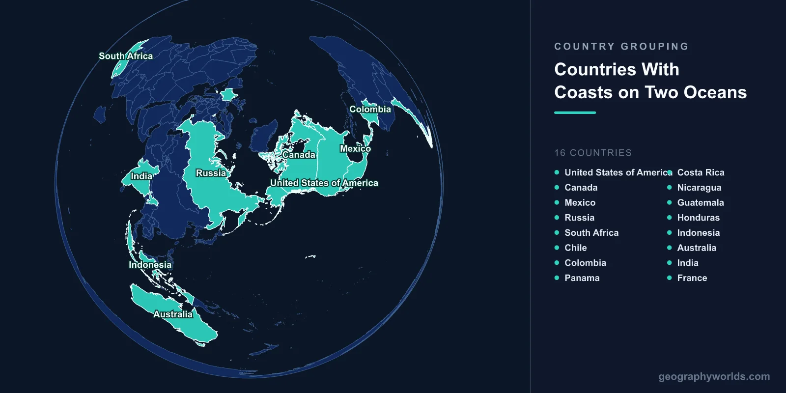
A limited group of countries has coastline on two different oceans, including the United States, Canada, Mexico, Russia, South Africa, Chile, Colombia, Panama, Costa Rica, Nicaragua, Guatemala, Honduras, Indonesia, Australia, India and France. The exact membership depends on a question with no settled answer: where one ocean ends and the next begins.
Why the List Is Arguable
There is no universally binding definition of ocean boundaries. The International Hydrographic Organization publishes limits, most recently in a 1953 edition with a 2002 draft that was never formally adopted, and national authorities differ from it and from each other.
The Southern Ocean is the sharpest case. The IHO's 2000 proposal recognised it as a separate ocean south of 60 degrees south; several member states objected, Australia defines it as extending much further north along its own coast, and National Geographic only began labelling it in 2021. Whether Australia, Chile, Argentina and South Africa touch the Southern Ocean depends on which authority you follow.
The Arctic is similarly contested: some treat it as an ocean, others as a mediterranean sea of the Atlantic. That single choice determines whether Russia, Canada, Norway and the United States are two-ocean countries or three.
The Unambiguous Cases
A handful of countries are on the list under any definition, because they front the Atlantic and Pacific basins directly.
Panama is the emblem. The isthmus is about 80 kilometres wide at the canal, and the country's shape means the Caribbean is north and the Pacific south. Because the isthmus runs east to west rather than north to south, the canal's Pacific entrance at Panama City lies further east than its Atlantic entrance at Colón — so a ship transiting from the Atlantic to the Pacific travels south-east.
Colombia is the only South American country with both Caribbean and Pacific coasts, which is why Cartagena and Buenaventura serve completely different trade routes.
Costa Rica, Nicaragua, Guatemala and Honduras all span the Central American isthmus with coast on both sides, though Honduras's Pacific frontage is only a short stretch inside the Gulf of Fonseca, shared with El Salvador and Nicaragua under a condominium arrangement.
Mexico, the United States and Canada each front the Pacific and the Atlantic, with Canada and the United States also reaching the Arctic.
The Ones That Depend on the Arctic
Russia has the longest coastline of any country and touches the Arctic along its entire northern edge and the Pacific in the far east. It also reaches the Atlantic through the Baltic and the Black Sea, depending on whether those enclosed seas are counted as ocean access.
The Northern Sea Route along that Arctic coast has become commercially significant as ice cover has declined, cutting the distance between north-east Asia and northern Europe by thousands of kilometres compared with the Suez route. Whether Russia is a two-, three- or four-ocean country is a matter of bookkeeping; the strategic point is that its Pacific and Atlantic fleets cannot reinforce each other except by that route or by circumnavigation.
Canada is the clearest three-ocean case — Pacific, Atlantic and Arctic — and its Arctic Archipelago contains the Northwest Passage, whose legal status Canada and the United States have disagreed about for decades.
The Ones That Depend on the Indian Ocean Boundary
South Africa is conventionally described as the meeting point of the Atlantic and Indian oceans, and the country markets Cape Agulhas, its southernmost point, as the dividing line — the IHO places the boundary on the 20 degrees east meridian, which runs through Agulhas.
The more famous Cape of Good Hope is not the southern tip and not the boundary, a persistent misconception. What is true is that the two water masses meeting there behave very differently: the warm Agulhas Current running down the east coast and the cold Benguela running up the west produce one of the most dangerous stretches of sea anywhere, with freak waves that have broken large ships.
India fronts the Indian Ocean on three sides through the Arabian Sea and the Bay of Bengal, both of which are parts of the same ocean — so India qualifies only if those are counted separately, which most authorities do not. Indonesia is the stronger case, straddling the boundary between the Indian and Pacific oceans through its archipelago.
France, and the Overseas Territories Problem
France appears on this list for a reason that has nothing to do with Europe. Metropolitan France fronts the Atlantic and the Mediterranean. But French territory includes Guadeloupe and Martinique in the Caribbean, French Guiana on the South American mainland, Réunion and Mayotte in the Indian Ocean, and French Polynesia and New Caledonia in the Pacific.
That gives France the second-largest exclusive economic zone in the world, after the United States, spread across every ocean. The United Kingdom, the Netherlands and the United States are in comparable positions through their own overseas territories.
Whether this counts is a question about what a country is. If overseas territory counts, the list of two-ocean countries expands considerably; if only the metropolitan landmass counts, several fall off.
The Countries That Look Like They Qualify and Do Not
Several near-misses are instructive.
- Israel has Mediterranean coast and a short frontage on the Gulf of Aqaba at Eilat, which leads to the Red Sea and the Indian Ocean. Two seas, two ocean basins, but the Mediterranean is part of the Atlantic, so this is arguably Atlantic and Indian.
- Egypt has the Mediterranean and the Red Sea, and the Suez Canal between them — the same Atlantic-to-Indian relationship, achieved by engineering.
- Turkey has the Mediterranean, Aegean and Black Sea coasts, all connected to the Atlantic basin through the Bosphorus and Gibraltar.
- Chile and Argentina both face one ocean under the traditional scheme and two if the Southern Ocean is recognised, with Chile reaching Cape Horn.
Why It Matters Commercially
Having two ocean coasts is worth a great deal, because it removes the need to route around a continent.
Before the Panama Canal opened in 1914, a ship from New York to San Francisco sailed around Cape Horn — roughly 22,500 kilometres. Through the canal it is about 9,500. That saving is why the canal was worth building, why the United States backed Panama's secession from Colombia in 1903, and why Nicaragua's rival canal proposal has been revived repeatedly and never built.
Colombia's two coasts serve entirely separate markets, which is why Buenaventura handles Pacific trade with Asia while Cartagena handles the Atlantic. Mexico is currently developing the Interoceanic Corridor across the Isthmus of Tehuantepec — a rail land-bridge intended to compete with the canal by moving containers overland between two of its own ports.
Where the Boundaries Are Actually Drawn
For anyone wanting the conventional answers rather than the arguments, the IHO limits run roughly as follows.
The Atlantic and Indian oceans divide at the 20 degrees east meridian running south from Cape Agulhas. The Indian and Pacific divide along a line from the Malay Peninsula through the Indonesian archipelago to Australia, then down the 146 degrees 55 minutes east meridian from Tasmania. The Atlantic and Pacific divide at the Drake Passage on the 67 degrees 16 minutes west meridian from Cape Horn.
The Arctic is bounded from the Atlantic through the Greenland and Norwegian seas and the Bering Strait, and the Southern Ocean, where recognised, begins at 60 degrees south.
These lines are conventions for hydrographic charting rather than physical features. Water crosses them freely, and the thermohaline circulation — the global conveyor that carries surface water from the North Atlantic to the deep Pacific and back over roughly a thousand years — treats the whole system as one ocean, which oceanographers frequently point out is the more accurate way to think about it.
Two Coasts, Two Navies
The strategic consequence of a two-ocean coastline is that a navy must either be split or able to move between basins quickly.
The United States maintains Pacific and Atlantic fleets, and the desire to shift warships between them without rounding South America was an explicit motive for building the Panama Canal — the locks were sized in part around the battleships of the era, and the Panamax standard that governed world shipping for a century was set by that decision.
Russia faces the same problem without a solution: its Northern, Baltic, Black Sea and Pacific fleets are separated by distances that make mutual reinforcement impractical, which is why the Northern Sea Route matters militarily as well as commercially. Colombia likewise operates separate Caribbean and Pacific commands.
The Countries With No Coast At All
The opposite condition is far more common than this one. Forty-four countries are landlocked, and two — Liechtenstein and Uzbekistan — are doubly landlocked, surrounded entirely by other landlocked states.
The contrast frames what the two-ocean countries have. Bolivia lost its Pacific coast to Chile in the War of the Pacific and has pursued the claim for over a century, maintaining a navy on Lake Titicaca and marking a Day of the Sea each March. Ethiopia became landlocked when Eritrea separated in 1993 and has been pressing for sea access since, to the point of a memorandum with Somaliland in 2024 that nearly triggered a regional crisis.
Access to one ocean is worth going to war over. Access to two is the reason the isthmus countries have been strategically contested since the sixteenth century. States at the other end of this spectrum are covered in the world's landlocked countries, while the countries with the longest coastlines ranks them by how much sea they actually touch.
