
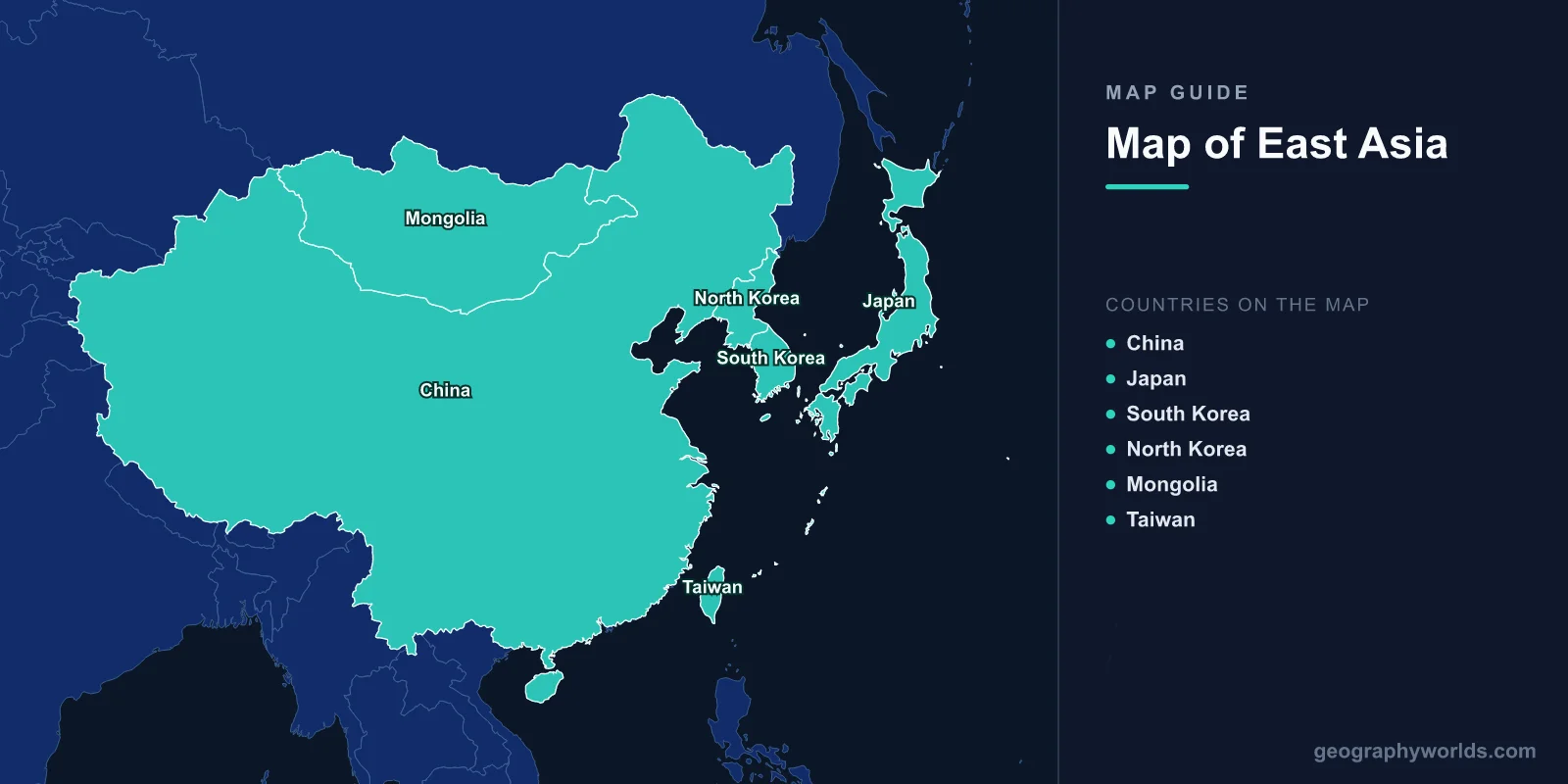
East Asia is the eastern part of the Asian continent, usually defined as China, Japan, Mongolia, North Korea, South Korea and Taiwan, together with China's special administrative regions of Hong Kong and Macau. The region covers about 11.8 million km², a little more than the whole of Europe, and is home to about 1.65 billion people, roughly a fifth of humanity. On a map it runs from the deserts and steppe of Mongolia and western China, through the Tibetan Plateau and the great river plains of eastern China, to the island arcs of Japan and Taiwan on the edge of the Pacific.
The Countries at a Glance
| Country or territory | Area | Population (approx.) | Capital |
|---|---|---|---|
| China | ~9.6 million km² | ~1.41 billion | Beijing |
| Mongolia | ~1.56 million km² | ~3.5 million | Ulaanbaatar |
| Japan | ~378,000 km² | ~124 million | Tokyo |
| North Korea | ~120,500 km² | ~26 million | Pyongyang |
| South Korea | ~100,400 km² | ~51.7 million | Seoul |
| Taiwan | ~36,000 km² | ~23.4 million | Taipei |
| Hong Kong (China) | ~1,100 km² | ~7.5 million | — |
| Macau (China) | ~33 km² | ~0.7 million | — |
China alone makes up about four-fifths of the region's land and more than four-fifths of its people. Taiwan governs itself but is claimed by China and recognised as a state by only about a dozen countries. Some definitions of East Asia also include the Russian Far East, though it is usually treated as part of Russia and North Asia.
Three Steps Down From the Roof of the World
Geographers often describe China's landscape as a staircase of three steps descending from west to east, and it explains much of the region's map. The highest step is the Tibetan Plateau, averaging about 4,500 m above sea level and covering some 2.5 million km², bounded to the south by the Himalaya. Mount Everest, at 8,849 m, stands on its southern edge on the border between China and Nepal. The plateau is the source of Asia's great rivers, including the Yangtze, the Yellow River and the Mekong, and for that reason it is sometimes called the "water tower of Asia".
The middle step is a belt of basins and plateaus at roughly 1,000 to 2,000 m: the Loess Plateau, whose fine yellow wind-blown soil gives the Yellow River its colour; the Sichuan Basin, one of China's most populous regions; the Mongolian Plateau; and the deserts of the Tarim Basin and the Gobi. The lowest step is the eastern plains and hills, the North China Plain and the middle and lower Yangtze, where most Chinese people live.
Deserts and Steppe in the North and West
Much of the interior is dry. The Gobi Desert, covering about 1.3 million km² across southern Mongolia and northern China, is a cold desert, mostly bare rock and gravel rather than sand, with winter temperatures far below freezing. Further west, the Taklamakan, in the Tarim Basin of Xinjiang, is one of the largest sandy deserts in the world, ringed by the Tian Shan and Kunlun mountains. Our guide to where the Gobi Desert is maps it in detail.

North of the deserts, Mongolia is mostly high grassland steppe, the least densely populated country in the world, with about two people per km². Ulaanbaatar, its capital, is often called the coldest national capital, with January averages around −20 °C.
The Rivers That Built China
The Yangtze, about 6,300 km long, is the longest river in Asia and the third-longest in the world. It flows from the Tibetan Plateau through the Three Gorges, where the world's largest hydropower dam now stands, to the East China Sea at Shanghai. Its basin holds about a third of China's population and produces a large share of its rice.

The Yellow River, about 5,460 km long, is the cradle of early Chinese civilisation. Its load of loess silt is so heavy that the riverbed has built up above the surrounding plain in its lower course, held in by dykes. When those have failed, the floods have been among the deadliest natural disasters in history, which earned it the name "China's Sorrow". In the north-east, the Amur and its tributary the Ussuri form much of the border with Russia. Our guide to the Yangtze follows the river from source to sea.
Peninsulas, Islands and the Ring of Fire
East Asia's eastern edge lies on the Pacific Ring of Fire, where the Pacific and Philippine Sea plates sink beneath Asia. The Korean Peninsula projects about 1,000 km south between the Yellow Sea and the Sea of Japan, divided since 1953 by the Demilitarized Zone near the 38th parallel. The zone is about 250 km long and 4 km wide, and our guide to the Korean DMZ explains how the line was drawn.
Japan is an archipelago of four main islands, Honshu, Hokkaido, Kyushu and Shikoku, and thousands of smaller ones, stretching about 3,000 km from north-east to south-west. About three-quarters of it is mountainous, and it has more than a hundred active volcanoes, including Mount Fuji, at 3,776 m. Earthquakes are frequent. The magnitude 9.0 Tōhoku earthquake of March 2011 and its tsunami left about 18,500 people dead or missing and caused the Fukushima nuclear accident. Taiwan, about 160 km off the Chinese coast, is dominated by a central mountain range rising to almost 4,000 m at Yushan, with most people living on the western plains.

A Shared Cultural Map
East Asia is not only a physical region. For some two thousand years its peoples were linked by China's influence, and geographers sometimes call it the Sinosphere. Chinese characters spread to Korea, Japan and Vietnam and were used for government and scholarship across the region. Japanese still writes with thousands of them, called kanji, alongside its own syllabaries. Korea used them for official writing until King Sejong's court created the Hangul alphabet in 1443, and Hangul slowly replaced them in everyday use in the twentieth century.
Confucian ideas about family, education and the state, and Mahayana Buddhism, which reached China from India along the Silk Road and travelled on to Korea by the fourth century and Japan by the sixth, also spread across the region. So did rice farming in flooded paddies, chopsticks, and a calendar based on the moon, which is why the Lunar New Year is the biggest holiday in China, Korea, Taiwan and Vietnam, though Japan moved its New Year to 1 January in 1873. Mongolia is the exception to much of this: its nomadic herding culture, Tibetan Buddhism and, since the 1940s, a Cyrillic alphabet set it apart from its neighbours.
Monsoon Climate and Crowded Coasts
Most of the populated east has a monsoon climate. In summer, warm, moist winds from the Pacific bring heavy rain, and typhoons strike the coasts of southern China, Taiwan, Japan and Korea, usually between July and October. In winter, cold, dry winds blow out of Siberia and Mongolia, making Beijing and Seoul much colder in January than cities at the same latitude in Europe. The contrast between the wet east and the dry west roughly follows a line drawn from Heilongjiang in the north-east to Yunnan in the south-west. When the geographer Hu Huanyong first drew this line in 1935, about 96 per cent of China's people lived east of it on about 36 per cent of the land, and the share has barely changed since.
The coasts hold some of the densest and largest urban regions on Earth: the Pearl River Delta around Guangzhou, Shenzhen and Hong Kong; the Yangtze Delta around Shanghai; the Beijing–Tianjin region; greater Tokyo, the largest metropolitan area in the world by many measures; and the Seoul Capital Area.
An Economic Powerhouse
Over the past seventy years East Asia has become one of the centres of the world economy. Japan rebuilt after 1945 and was the world's second-largest economy by the late 1960s. South Korea, Taiwan and Hong Kong followed, growing so fast from the 1960s to the 1990s that, with Singapore, they were nicknamed the "Four Asian Tigers". South Korea went from being one of the poorest countries in the world after the Korean War to a leading maker of ships, cars, phones and memory chips. Taiwan makes most of the world's most advanced computer chips. China's reforms, begun by Deng Xiaoping in 1978, then lifted hundreds of millions of people out of poverty and made it the world's largest manufacturer and trading nation. Together, China, Japan and South Korea produce roughly a quarter of the world's output.
North Korea is the stark exception. Closed off under the Kim family since 1948, it remains one of the poorest and most isolated countries on Earth, and satellite photographs of the peninsula at night show the South brightly lit and the North almost completely dark.
Seas and Disputed Islands
Several marginal seas separate the mainland from the island arcs: the Sea of Japan, called the East Sea in Korea; the Yellow Sea; the East China Sea; and to the south, the South China Sea. Their islands are the subject of some of the region's most persistent disputes. Japan and China both claim the Senkaku Islands, called Diaoyu in China. South Korea controls, and Japan claims, the Dokdo or Takeshima islets. Russia and Japan dispute the southern Kurils. These arguments are mostly over rocks and small islands, but they matter because each one carries rights to fishing grounds and the seabed around it. The East China Sea, where several of these claims overlap, is described in our guide to the East China Sea.