
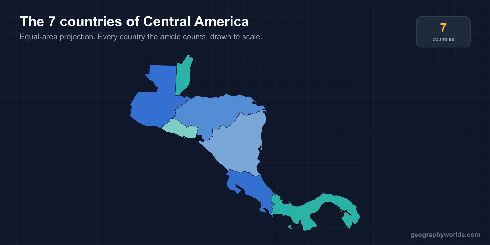
There are seven countries in Central America: Belize, Costa Rica, El Salvador, Guatemala, Honduras, Nicaragua and Panama. Together they occupy roughly 523,000 square kilometres on the isthmus linking North and South America, with a combined population of about 50 million.
The seven countries, north to south
The isthmus narrows steadily from the Mexican border to Colombia, and the countries follow that line in a clear sequence.
- Guatemala — about 108,900 km², roughly 18 million people, capital Guatemala City. The most populous country in Central America and the one with the largest Indigenous population share.
- Belize — about 22,970 km², roughly 410,000 people, capital Belmopan. The smallest by population and the only English-speaking state on the isthmus.
- Honduras — about 112,490 km², roughly 10.5 million people, capital Tegucigalpa. The largest by area.
- El Salvador — about 21,040 km², roughly 6.4 million people, capital San Salvador. The smallest by area and the only one without a Caribbean coast.
- Nicaragua — about 130,370 km², roughly 7 million people, capital Managua. Contains Lake Nicaragua, the largest lake in the region.
- Costa Rica — about 51,100 km², roughly 5.2 million people, capital San José. Abolished its standing army in 1948.
- Panama — about 75,420 km², roughly 4.5 million people, capital Panama City. Controls the canal linking the Atlantic and Pacific.
All seven are members of the Central American Integration System (SICA), founded in 1993, which also admits the Dominican Republic as a full member despite its Caribbean location — one of several reasons the region's membership lists rarely agree.
Why Belize is the odd one out
Belize breaks nearly every pattern that otherwise holds across the isthmus, and the reasons are entirely colonial.
While Spain claimed and settled the rest of the region, English logwood cutters established themselves on the Belizean coast from the seventeenth century, exploiting a stretch of shoreline Spain never effectively occupied. The territory became British Honduras, a Crown colony, and did not gain independence until 1981 — more than 150 years after its neighbours.
The consequences are visible in almost every measure. English is the official language, and Belizean Creole is widely spoken alongside Spanish, Garifuna, Q'eqchi' and Mopan Maya. The legal system is common law rather than civil law. Belize belongs to CARICOM, the Caribbean Community, as well as to SICA, and its cultural and sporting ties often run east to Jamaica rather than west to Guatemala. Charles III remains head of state.
Its geography differs too. Belize is low-lying and flat across much of its north, lacking the volcanic spine that defines its neighbours, and the Belize Barrier Reef off its coast is the largest reef system in the Atlantic. Population density is by far the lowest in the region.
The border dispute that has never been settled
Guatemala has claimed all or part of Belizean territory since the nineteenth century, and the dispute remains formally live.
The claim rests on an 1859 treaty between Britain and Guatemala that fixed the boundary in exchange for British commitments — Guatemala's position is that Britain did not fulfil them, so the treaty lapsed and the underlying Spanish colonial claim revives. Britain rejected that reading. Guatemala did not recognise Belize at all until 1991, a decade after independence, and British troops remained stationed there as a deterrent for years afterwards.
Both countries held referendums agreeing to submit the case to the International Court of Justice — Guatemala in 2018, Belize in 2019 — and the case is now before the court in The Hague. The disputed area covers a substantial share of southern Belize. In the meantime an "adjacency zone" is monitored by the Organization of American States, and incidents along it recur.
It is not the only unresolved boundary. Honduras and El Salvador fought a brief war in 1969, remembered as the Football War though its causes were migration and land pressure, and their maritime boundaries in the Gulf of Fonseca — shared with Nicaragua — took decades of litigation to partially settle.
Central America, Mesoamerica and the Northern Triangle
Three overlapping terms cause most of the confusion around the region's membership, and they are not interchangeable.
- Central America is a geographic and political term for the seven countries listed above, occupying the isthmus between Mexico and Colombia.
- Mesoamerica is a cultural and archaeological term for the region where the Maya, Aztec, Olmec and related civilisations developed. It includes central and southern Mexico and reaches only as far south as roughly Costa Rica, so it both extends beyond Central America and stops short of it.
- The Northern Triangle refers specifically to Guatemala, Honduras and El Salvador, grouped in policy discussions of migration, security and development.
A further complication is that some Latin American traditions count Mexico as part of Central America, or treat the region as a subdivision of North America rather than a separate entity. Under the common United Nations geoscheme, Central America is a subregion of North America and includes Mexico, giving eight countries rather than seven. Mexico itself is generally not considered Central American in everyday English usage, and Mexicans do not describe their country that way.
Panama presents the mirror-image problem. It was a province of Colombia until 1903 and is physically attached to South America at the Darién, so it was historically counted as South American. Its separation — supported by the United States in the context of canal negotiations — moved it into the Central American grouping, where it has remained. The definition of an isthmus is what holds the whole regional concept together.
The volcanic spine that runs the length of the isthmus
A chain of volcanoes runs almost unbroken from Guatemala to Panama, produced by the Cocos Plate subducting beneath the Caribbean Plate along the Middle America Trench. This single geological fact organises much of the region's human geography.
Guatemala alone has more than 30 volcanoes, several persistently active — Fuego erupts frequently, and its 2018 eruption killed hundreds. Nicaragua's Masaya has an accessible lava lake. Costa Rica's Arenal was continuously active from 1968 to 2010. El Salvador is nicknamed the "land of volcanoes" and its capital sits beside one.
Volcanic soils are exceptionally fertile, and the highland valleys they created are where most of the population lives — not on the hot, humid coasts. Coffee cultivation in Guatemala, Honduras, Nicaragua and Costa Rica depends almost entirely on this combination of volcanic soil and altitude.
The cost is severe seismic exposure. Managua was destroyed by earthquakes in 1931 and again in 1972; Guatemala's 1976 earthquake killed more than 20,000 people. The same subduction that supplies the soil supplies the hazard.
Two coasts that function as different worlds
Every Central American country except El Salvador has both a Pacific and a Caribbean coastline, and the two sides differ so sharply that they operate almost as separate regions.
The Pacific side is drier, with a pronounced dry season, and it is where the Spanish concentrated their settlement. Almost every capital except Belmopan lies on the Pacific slope or in the highlands behind it, and the major road network, the airports and the bulk of the population follow that axis.
The Caribbean side receives far heavier rainfall — parts of the Nicaraguan and Honduran coast exceed 3,000 millimetres a year — and remained thinly settled and poorly connected for centuries. Its population history is distinct: the Miskito on the Nicaraguan and Honduran coast maintained autonomy from Spanish control well into the nineteenth century, and Afro-Caribbean communities, including the Garifuna, arrived through British trade and forced migration rather than Spanish colonisation. English and creole languages are still widely spoken along that shore, in countries whose official language is Spanish.
The economic divide followed. Banana plantations established by United States companies from the late nineteenth century transformed the Caribbean lowlands of Honduras, Costa Rica and Guatemala into export enclaves with their own railways and ports, generating enormous political leverage — the origin of the phrase "banana republic". Development indicators on the Caribbean side still lag those on the Pacific in most of these countries.
The republic that briefly made them one country
The seven states were not always separate, and the memory of union still shapes regional politics.
After independence from Spain in 1821 and a brief period within the Mexican Empire, Guatemala, El Salvador, Honduras, Nicaragua and Costa Rica formed the Federal Republic of Central America in 1823. It lasted until 1838, collapsing under conflict between liberal and conservative factions and the reluctance of the provinces to accept a central authority. Its flag — blue and white horizontal bands — is the direct ancestor of the modern flags of El Salvador, Honduras, Nicaragua and Guatemala, which is why they resemble each other so closely.
Reunification attempts followed repeatedly through the nineteenth century and all failed. The modern successor is institutional rather than political: SICA, a customs union among four members, a Central American Court of Justice, and a parliament in Guatemala City with limited powers.
Panama and Belize, having joined the region by different routes, sit somewhat apart from that history — which is a reasonable summary of the region as a whole. For more on the individual states, our Costa Rica country guide and Guatemala country guide go into each in depth.
