
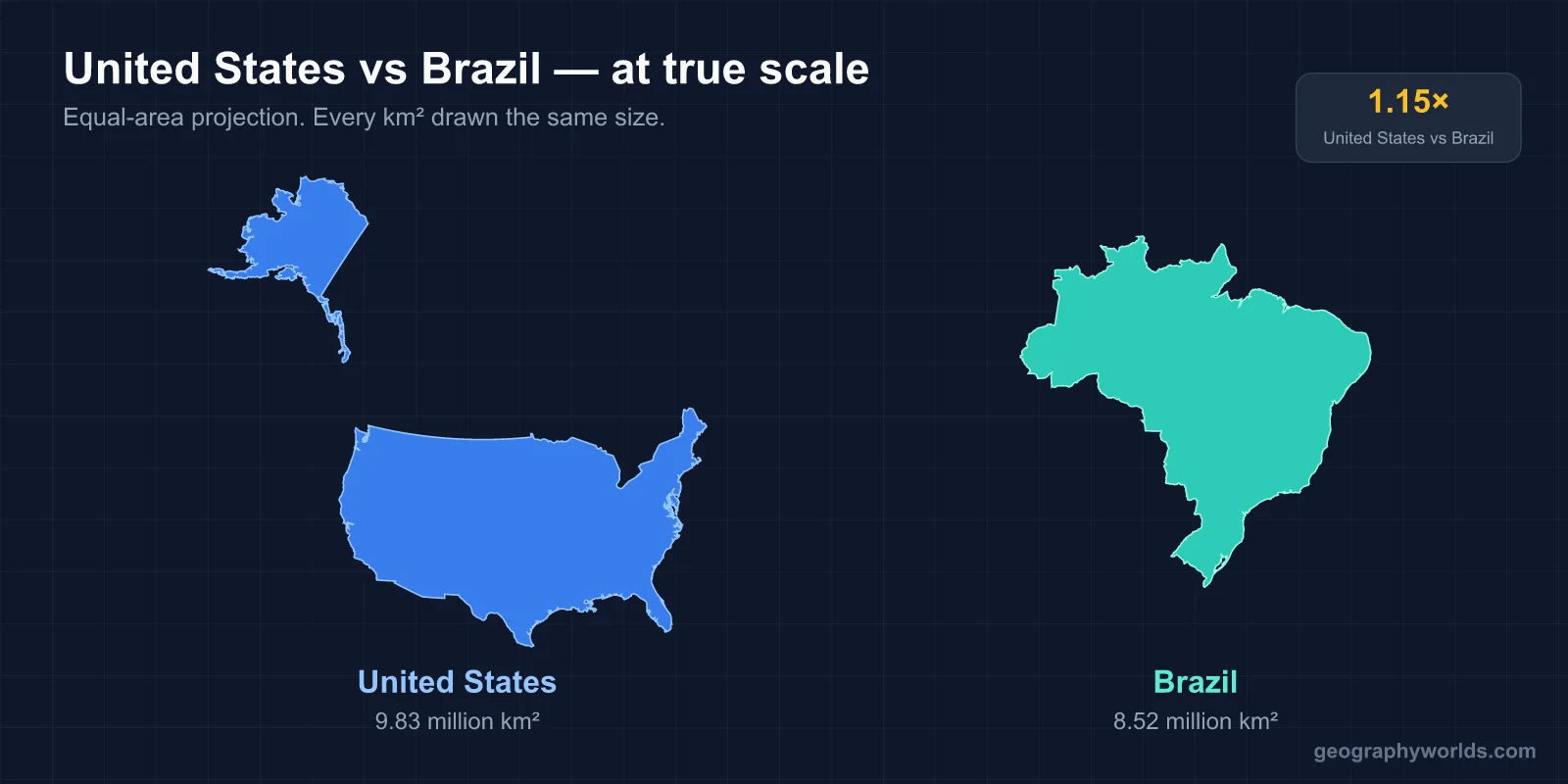
No. The United States is slightly larger than Brazil. The US covers 9,833,520 km² while Brazil covers 8,515,767 km² — making the US about 15% larger. Both are top-5 countries by area, and they're closer in size than most people realize.
The Short Answer
Brazil and the United States are the two largest countries in the Americas, and they're much closer in size than the standard mental picture suggests. The US edges out Brazil by about 1.3 million km² — roughly the size of Peru or Mongolia stacked on top of Brazil. But in a global ranking, both are continental-scale: the US is 3rd or 4th, Brazil is 5th. They're neighbors on the list.
If you removed Alaska from the United States, Brazil would actually be bigger than the contiguous US. Alaska accounts for 1.72 million km² — about 17.5% of the total US area. Without it, the lower 48 states cover about 8.1 million km², which is smaller than Brazil's 8.52 million km².

The Real Numbers
- United States total area: 9,833,520 km²
- Brazil total area: 8,515,767 km²
- Difference: 1,317,753 km² — about the size of Peru
- Ratio: The US is about 1.15× the size of Brazil
- US without Alaska: ~8.11 million km² — smaller than Brazil
By comparison, the next largest country in the Americas after Brazil is Argentina at 2.78 million km² — Argentina is only about a third the size of Brazil. Then Canada at 9.98 million km² (slightly larger than the US). Brazil is in a class by itself in South America, much like the US dominates North America.
How Do They Compare to Their Continents?
Brazil covers about 47.3% of South America's total land area (17.84 million km²). It borders every South American country except Chile and Ecuador. That dominance is unusual — most continents don't have a single country covering nearly half their area.
The United States covers about 39.8% of North America's land area (24.71 million km²). Canada takes up another 40.5%, with Mexico, Central America, and the Caribbean splitting the remainder. So North America is more "shared" between two giants (US and Canada), while South America is dominated by one (Brazil).
Population: A Massive Gap
The US has about 333 million people. Brazil has about 215 million. So the US has roughly 55% more population in just 15% more land — making the US about 35% denser overall:
- US population: ~333,000,000
- Brazil population: ~215,000,000
- US density: ~36 people per km²
- Brazil density: ~25 people per km²
Both countries have huge swaths of sparsely populated land — the Amazon basin in Brazil, the Mountain West and Alaska in the US. But the US has more total population spread across more developed areas, while Brazil's population is heavily concentrated along its Atlantic coast.
Population Distribution: Coast vs. Interior
About 80% of Brazilians live within 200 km of the Atlantic coast. The interior — especially the Amazon — is enormous but sparsely settled. Manaus, deep in the Amazon, is the only major city with more than a million people in the interior. The coastal megacities (São Paulo with 22 million metro, Rio de Janeiro with 13 million, Salvador, Recife, Fortaleza) dominate Brazilian life.
The US is more evenly distributed. While the Northeast Corridor and California are heavily populated, large metropolitan areas exist in every region — Chicago, Houston, Atlanta, Phoenix, Seattle, Miami, Denver, Minneapolis, and dozens more. There's no equivalent to the Amazon-style population emptiness in the US, except parts of Alaska.
Geographic Diversity
Both countries have remarkable geographic range. The US spans nine climate zones from arctic Alaska to tropical Hawaii, with the contiguous US covering temperate, subtropical, desert, and prairie zones. It has the Rocky Mountains, Appalachians, Great Plains, Sierra Nevada, the Mississippi River basin, the Gulf Coast, the Great Lakes, and three ocean coasts.
Brazil is largely tropical, with subtropical southern states. It contains the Amazon (the world's largest rainforest), the Cerrado (a vast tropical savanna), the Pantanal (the world's largest tropical wetland), the Atlantic Forest, and a long coastline along the Atlantic. Brazil has no mountains as high as the Rockies — its highest peak (Pico da Neblina) is just 2,995 m — and no real cold climate zones outside southern winter snow.
Why Brazil Looks Smaller
On a Mercator map, Brazil appears smaller than it really is because most of it sits between 5°N and 33°S — right around the equator. Mercator compresses tropical regions and inflates polar ones, which means Brazil looks proportionally smaller than countries at higher latitudes.
Switch to an equal-area projection like Gall-Peters or Equal Earth and Brazil suddenly looks enormous — close to its actual size relative to the United States. This is the same distortion that makes Greenland look gigantic and Africa look smaller than it is.
Economy
The gap is much wider in economic terms than in physical size. US GDP is approximately $26.9 trillion. Brazil's GDP is approximately $2.13 trillion. The US economy is more than 12 times larger than Brazil's. Per capita, US GDP is about $80,000, while Brazil's is about $10,000 — an 8× gap.
Both are members of the G20, both are major commodity exporters, and both have continent-spanning infrastructure. But the development levels are very different. The US is highly industrialized and services-driven; Brazil remains heavily agricultural and resource-based, with a developing industrial sector.
The Amazon Factor
The Amazon rainforest covers about 5.5 million km² across 9 countries, with about 60% of it in Brazil — roughly 3.3 million km², or about 39% of Brazil's total land area. That single ecosystem is larger than the entire Mediterranean basin and about a third the size of the United States by itself.
The US has no equivalent. The closest analog is the wilderness of Alaska (over 1 million km² of national parks, forests, and protected areas), but that's scattered across a much colder, more remote landscape. The Amazon is one continuous tropical biome, and it shapes Brazil's climate, economy, and global environmental significance.
Coastlines and Time Zones
Brazil has a 7,491-km Atlantic coastline — the 16th longest in the world — running from the Amazon delta in the north to the southern tip near Uruguay. The US has roughly 19,924 km of coastline counting the Pacific, Atlantic, Gulf of Mexico, Arctic Alaska coast, and Hawaii. That gives the US about 2.7× the coastline of Brazil, primarily because of Alaska's deeply indented shoreline and the fact that the US faces three oceans while Brazil faces one.
Time zones tell another story. Brazil officially uses 4 time zones, though only 3 are populated (the westernmost zone covers a tiny Atlantic island chain). The US uses 6 time zones across its main territories (Pacific, Mountain, Central, Eastern, Alaska, Hawaii-Aleutian). When it's noon in Boston, it's 6 AM in Honolulu — a 6-hour spread across a single country.
Key Facts
- The US is about 15% larger than Brazil.
- Without Alaska, the US would be smaller than Brazil.
- Brazil covers 47% of South America; the US covers 40% of North America.
- The US has 55% more people than Brazil and roughly 40% higher population density.
- About 60% of the Amazon rainforest sits within Brazil's borders.
Fun Facts
- Brazil and the US are the only two countries with all 6 major continental climate types within their borders.
- Brazil borders every South American country except Chile and Ecuador — 10 in total.
- The US borders only 2 countries (Canada, Mexico), though it has maritime borders with several more.
- São Paulo, Brazil is roughly the same size as New York City but with about 50% more people.
- The Amazon River alone discharges more water than the next seven largest rivers in the world combined.
The Bottom Line
The US is bigger than Brazil — but not by much, and not at all if you exclude Alaska from the comparison. These are two of the largest, most ecologically diverse, and economically significant countries on Earth. They're close enough in size that the answer turns on where you draw the lines.
If anything, the comparison highlights how unusual both countries are. Most of the world's land area is split among hundreds of smaller nations. Brazil and the US are among the rare giants that span entire continents — and they sit right next to each other on the world ranking list, separated by just one Peru-sized chunk of land.