
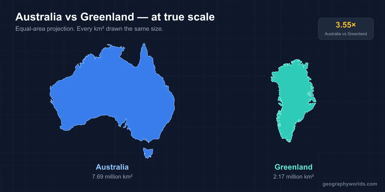
No. Australia is far larger than Greenland. Australia covers 7,692,024 km² (2,969,907 sq mi), while Greenland covers 2,166,086 km² (836,330 sq mi). Australia is about 3.55 times the size of Greenland — large enough that more than three Greenlands could fit inside Australia's borders.
The Short Answer
This is one of the great Mercator map illusions. On standard wall maps, Greenland looks roughly the same size as Australia — sometimes even bigger. In reality, Australia is over three and a half times larger. The visual confusion comes entirely from the Mercator projection, which inflates landmasses near the poles while preserving the size of landmasses near the equator.
Greenland sits between 60°N and 83°N — so it gets stretched dramatically. Australia spans 10°S to 44°S — close enough to the equator that Mercator distortion is minimal. The result: equal-looking blobs on a map, but a 3.55× size difference in reality.

The Real Numbers
- Australia total area: 7,692,024 km² (2,969,907 sq mi)
- Greenland total area: 2,166,086 km² (836,330 sq mi)
- Difference: 5,525,938 km² — roughly the size of Brazil's Amazon rainforest, or about 70% of Australia itself
- Ratio: Australia is about 3.55× the size of Greenland
Globally, Australia ranks 6th by country area, between Brazil and India. Greenland ranks 12th — between Saudi Arabia and the Democratic Republic of the Congo. The gap between them in the global ranking is six positions, not because there are six "close calls" between them but because the difference is genuinely huge.
Continent vs Country
Part of the confusion is taxonomic. Australia is classified as a continent (the smallest one, but a continent nonetheless), while Greenland is classified as the world's largest island. If Greenland were a continent, it would be much smaller than Australia — about 28% of Australia's size. The distinction between "world's largest island" and "world's smallest continent" comes down to convention as much as anything else, because both are large, isolated landmasses surrounded by ocean.
What makes Australia a continent and Greenland an island? Mostly tectonic: Australia sits on its own continental plate (the Australian Plate), while Greenland is part of the larger North American Plate. Cultural factors play a role too — Australia has a long indigenous human history (60,000+ years) and unique flora and fauna isolated from other landmasses, while Greenland has a more recent Norse/Inuit settlement history and ecology shared with the broader Arctic.
Why Mercator Lies About These Two
The Mercator projection (1569) was designed for ship navigation. It preserves the shape of small regions and angles between locations, which made it ideal for plotting compass courses. But it does this by stretching the map horizontally as you move away from the equator.
At 70°N latitude (central Greenland), the Mercator scale factor is about 2.9× — meaning everything is stretched to nearly 3× its real horizontal size. Since maps stretch in both dimensions to preserve angles, the visual area inflation is roughly 8-14× at those latitudes.
Australia, sitting around 25°S on average, gets only a tiny stretch — about 1.1× scale factor. So Mercator shrinks the visual contrast: Greenland looks 8-14× bigger than reality, while Australia looks about 1.1× bigger. The 3.55× actual size difference visually compresses to near-parity.
Population: The Gap Is Even Bigger
If Greenland and Australia are 3.55× apart in area, they're thousands of times apart in population:
- Australia population: ~26,000,000
- Greenland population: ~56,000
- Australia density: ~3.4 people per km²
- Greenland density: ~0.03 people per km²
Australia has about 465 times more people than Greenland. Australia's population density is low by world standards (similar to Canada), but Greenland's density is among the very lowest on Earth — comparable to Mongolia and a fraction of Australia's.
Both countries have populations concentrated in narrow zones: Australia's population mostly hugs the eastern and southwestern coasts (Sydney, Melbourne, Brisbane, Perth, Adelaide), while Greenland's population clusters along the southwestern coast (Nuuk, Sisimiut, Ilulissat).
Habitable Land Area
This is where the comparison gets even more lopsided. About 80% of Greenland is covered by a permanent ice sheet — so only roughly 20% (about 410,000 km²) is potentially habitable. Australia, by contrast, is mostly desert in the interior (the Outback covers about 70% of the country), but that desert is still habitable for ranching, mining, and indigenous communities. The truly uninhabitable part of Australia is much smaller as a percentage.
So while Australia is 3.55× larger by total area, its habitable land area is more like 15-20× larger than Greenland's. Australian agricultural land, urban land, and inhabited rural land vastly exceed anything possible in Greenland.
Climate Contrast
The two landmasses sit at near-opposite ends of the climate spectrum. Greenland is overwhelmingly polar — the ice sheet has an average summer temperature below freezing, and the interior never experiences temperatures above 0°C. Coastal Greenland reaches summer temperatures around 10°C.
Australia is mostly arid and warm. The interior reaches summer temperatures above 45°C. The Top End (Northern Territory) is monsoon-tropical, with two seasons (wet and dry) rather than four. Tasmania, the southernmost state, is cool-temperate and resembles parts of New Zealand or the UK.
The combined climate range of Australia's landmass spans from tropical to cool-temperate. Greenland's is from polar to subarctic. There's essentially no overlap.
Economy
Australia is a developed-economy giant. Its GDP is about $1.7 trillion — placing it in the top 15 economies globally. Greenland's GDP is about $3 billion, comparable to a small US town. Australia's economy is roughly 570× larger than Greenland's.
Australia's economy revolves around mining (iron ore, coal, gold, lithium), agriculture (wheat, beef, wool, wine), services, finance, and tourism. Greenland's economy depends heavily on fishing, mining (rare earth minerals, uranium), tourism, and substantial subsidies from Denmark.
Comparable Countries
Australia is comparable in area to the contiguous United States (8.1 million km²) — slightly smaller, but in the same range. Greenland is comparable to Saudi Arabia (2.15 million km²) or Mexico (1.96 million km²).
If you wanted to make Australia look about the same size as Greenland, you'd need to imagine compressing Australia to roughly Queensland-plus-New-South-Wales (the eastern half). That's the proportion Mercator hides.
Travel Time and Internal Distance
Traveling across Australia is itself a famous geographic feat. The drive from Perth (west coast) to Sydney (east coast) is roughly 3,930 km — about 41 hours of nonstop driving across the Nullarbor Plain. The Indian-Pacific train covers the same route in 65 hours over 4 days, billed as one of the world's great rail journeys. North-to-south from Darwin to Adelaide is about 3,000 km of mostly desert and savanna.
Greenland has nothing comparable. There are no roads connecting any two of its towns. Travel between settlements happens by boat in summer, by snowmobile or dogsled in winter, or by small aircraft year-round. The longest distance you could travel in Greenland is roughly 2,670 km from north to south — but you can't do it in one continuous overland journey. You'd need to ship-hop or fly. That logistical contrast captures something deep about how habitable land scales matter more than total area when it comes to how a place actually works.
Key Facts
- Australia is about 3.55× the size of Greenland.
- Australia has 465× more people than Greenland.
- Greenland's 2.17 million km² ranks it 12th globally; Australia's 7.69 million km² ranks 6th.
- Greenland is the world's largest island; Australia is the world's smallest continent.
- About 80% of Greenland is permanent ice; about 70% of Australia is desert outback.
Fun Facts
- Western Australia (a single state, 2.6 million km²) is larger than all of Greenland.
- Greenland and Australia's human histories are radically different — Aboriginal Australians have been continuous residents for ~60,000 years, while Greenland was settled by Inuit ancestors about 4,500 years ago and Norse around 1,000 years ago.
- Australia's population density of 3.4/km² is comparable to Iceland or Mongolia.
- If Greenland's ice sheet melted entirely, global sea levels would rise about 7.4 m — half of Australia's major coastal cities would be flooded.
- Australia and Greenland are roughly the same distance from their respective hemisphere's poles.
The Bottom Line
Greenland is not bigger than Australia — Australia is more than three and a half times larger. The visual illusion that they're similar in size is one of the most famous tricks of the Mercator projection. Once you switch to an equal-area map, the comparison becomes obvious: Australia is a continental giant, while Greenland is a large island that, despite its sometimes-continental treatment in news graphics, is just a fraction of Australia's size.
The next time you see Greenland looking enormous on a flat map, picture it overlapping with the state of Queensland and a bit of New South Wales — that's roughly the area it really covers, not the seemingly Africa-sized blob you see on a globe-warping projection.