
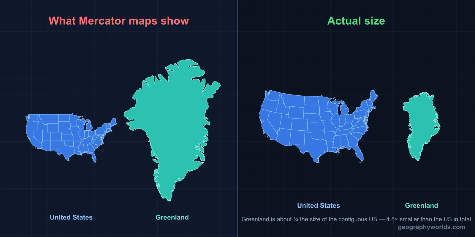
No. The United States covers about 9.83 million km² — roughly 4.5 times the size of Greenland's 2.17 million km². The illusion that Greenland is larger comes almost entirely from the Mercator projection, which stretches landmasses near the poles to fit them onto a rectangular map.
The Short Answer
On every Mercator wall map ever printed in a classroom, Greenland looks like it could swallow the contiguous United States whole. In reality, the US is almost five times larger. Texas alone (696,000 km²) is roughly one-third the size of Greenland, and Alaska — the largest US state — covers about 80% of it on its own.
This is one of the most persistent geographic misconceptions in the world, and it's not your fault for believing it. Standard wall maps, weather graphics on television, and even Google Maps at its default zoom level all use a version of the Mercator projection. After two decades of staring at a distorted image of Greenland, your brain encodes that distortion as reality.

The Real Numbers
- United States total area: 9,833,520 km² (3,796,742 sq mi)
- Greenland total area: 2,166,086 km² (836,330 sq mi)
- Ratio: The US is about 4.54× the size of Greenland
- Difference: 7,667,434 km² — almost exactly the area of Australia
Greenland is the world's largest island, but it sits in 12th place among countries and territories by area, between Saudi Arabia and the Democratic Republic of the Congo. The US is 3rd or 4th depending on how you count China's claims. So while Greenland is huge by island standards, it doesn't come close to a continental-scale country.
Even the contiguous United States — without Alaska or Hawaii — covers about 8.1 million km², still roughly 3.7 times larger than Greenland. So the answer doesn't change if you exclude the outlying states. The mainland US alone dwarfs Greenland.
Why Does Greenland Look So Big on Maps?
The Mercator projection — invented by Gerardus Mercator in 1569 for ship navigation — preserves angles, which is what sailors needed for plotting compass bearings. But to do that, it has to stretch the map horizontally as you move away from the equator. The closer to the poles, the more stretching.
Greenland sits between 60° N and 83° N latitude. At those latitudes, Mercator inflates area by roughly 4× to 14×. The result: Greenland on a Mercator map appears about the same size as Africa, even though Africa (30.4 million km²) is actually 14 times larger than Greenland.
The contiguous United States sits between 25° N and 49° N. It also gets stretched, but far less than Greenland. The disproportionate stretching is what creates the visual lie. Anything north of 60° latitude — Alaska, Scandinavia, Russia, Greenland — gets visually inflated. Anything near the equator — most of Africa, Indonesia, Brazil — appears smaller than it actually is.
What Fits Inside the US?
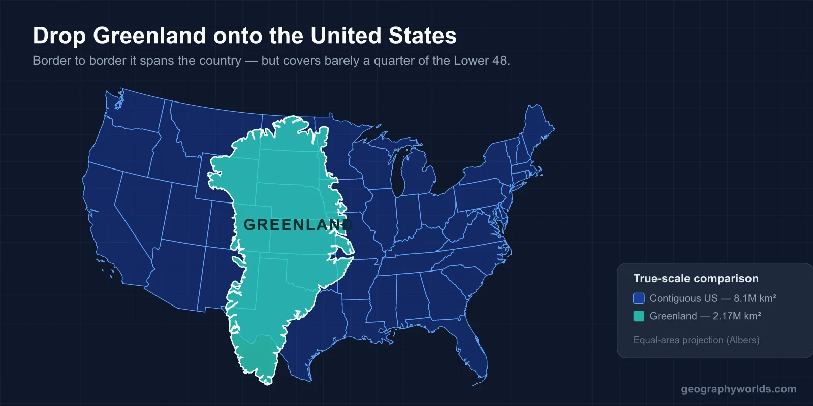
Here's the picture flipped. Greenland does not fit inside any single US state — not even Alaska. Alaska (1.72 million km²) comes closest, but Greenland is still about 443,000 km² larger, a gap roughly the size of California. Add California to Alaska and the two together land within 1% of Greenland's total area. Set against the lower 48 alone, Greenland would blanket Texas, California, Montana, New Mexico, and Arizona put together.
- Alaska: 1,723,337 km² — the largest US state, but still only about 80% of Greenland
- Texas: 696,200 km² — about one-third of Greenland
- California: 423,970 km² — one-fifth of Greenland
- Montana: 380,800 km² — one-sixth of Greenland
Those five states add up to about 2.11 million km² — within 3% of Greenland. Five states out of fifty account for the entire "vast" island most people picture as bigger than the whole country.
Population: Where the Comparison Gets Absurd
Size is one thing. Population is where Greenland and the United States diverge spectacularly. The US has about 333 million people. Greenland has 56,000 — fewer than a single midsize American suburb.
- US population: ~333,000,000
- Greenland population: ~56,000
- Ratio: The US has about 5,950× as many people
- US population density: ~36 people per km²
- Greenland population density: ~0.03 people per km²
About 80% of Greenland is covered by a permanent ice sheet up to 3 km thick. Only the coastal margins are habitable. The capital, Nuuk, has just over 18,000 residents — smaller than a typical US college town. Most Greenlandic settlements have only a few hundred people, connected to the rest of the country by boat or small aircraft. There are no roads connecting any two towns.
Climate and Habitability
The US spans from arctic Alaska to tropical Florida and Hawaii, crossing nine climate zones along the way. You can find deserts, rainforests, tundra, alpine peaks, swamps, prairie, and temperate forests within its borders. Greenland, by contrast, is dominated by a single defining feature: ice.
The Greenland Ice Sheet covers 1.7 million km² and reaches depths exceeding 3,000 meters in places. It contains roughly 8% of the world's freshwater. The ice-free fringe along the coast — the only inhabitable zone — represents only about 410,000 km² of usable land. Compare that to the US, where nearly the entire 9.8 million km² supports human settlement at some density.
This is why the size comparison feels so lopsided in practice. Even if Greenland were the same total area as the US, it would still support a fraction of the population because most of it is buried under ice that has been there for over 100,000 years.
What About a Better Projection?
Several map projections handle area honestly. The Gall-Peters projection makes Greenland look almost squashed by comparison to its Mercator self — and that's closer to the truth. The Robinson projection (used by National Geographic from 1988 to 1998) splits the difference: minor distortion in both shape and area. The Equal Earth projection, released in 2018, is the current go-to for area-preserving world maps.
In 2017, Boston Public Schools officially switched the maps used in classrooms from Mercator to Gall-Peters, prompted by a desire to show student populations a more accurate picture of the world. The change made headlines globally — partly because the new maps made Africa look dramatically larger and Europe noticeably smaller. Greenland in particular shrank to its real, modest size.
If you grew up looking at Mercator maps, switching to an equal-area projection is jarring. Africa balloons, Russia shrinks, India suddenly looks like the giant it actually is, and Greenland deflates into something that looks closer to its actual modest size — about the size of Algeria or the Democratic Republic of the Congo.
How the Greenland-vs-US Myth Got Reinforced
In 2019, when then-President Donald Trump publicly floated the idea of the United States purchasing Greenland from Denmark, the story dominated international news for weeks. Coverage repeatedly highlighted Greenland's "vast" landmass — and the maps used in news graphics were almost always Mercator-based, reinforcing the visual illusion of a Greenland that looked nearly continental in size.
Search traffic for "is Greenland bigger than the US" spikes during these news cycles. Many readers genuinely don't know, and the Mercator visualizations they see alongside the story don't help. The answer is no — by a long way — but the question keeps coming back precisely because the standard maps lie about the comparison.
Comparable Country Sizes
To put Greenland in proper context, here are some countries and regions of similar actual size:
- Saudi Arabia: 2.15 million km² — almost exactly the same as Greenland
- Mexico: 1.96 million km² — slightly smaller than Greenland
- Indonesia: 1.90 million km² — also smaller than Greenland
- Sudan: 1.86 million km² — about 86% the size of Greenland
- Libya: 1.76 million km² — about 81% the size of Greenland
None of these countries look anything like the size of the United States on a map. That's the right mental model for Greenland too. It's a large country by global standards, but it's nowhere near continental-scale.
Key Facts
- The US is about 4.5× larger than Greenland by total area.
- Alaska, the largest US state, is about 80% the size of Greenland — Greenland is roughly 26% larger.
- Mercator inflates Greenland's apparent area by up to 14×.
- Greenland's entire population (~56,000) is smaller than most US counties.
- Africa is 14× larger than Greenland, despite looking similar on Mercator.
- Boston Public Schools switched to Gall-Peters maps in 2017 to correct the distortion.
- The contiguous US (lower 48) alone is still about 3.7× larger than Greenland.
Fun Facts
- Greenland is actually the world's largest island that isn't classified as a continent — Australia is bigger but counts as a continent.
- If Greenland's ice sheet melted completely, global sea levels would rise about 7.4 meters.
- Greenland's name was a marketing trick — Erik the Red called it "Greenland" in 982 AD to attract Norse settlers to what was mostly ice.
- Greenland has more polar bears (~3,500) than members of its legislature (~31).
- You could fit roughly 4 Greenlands into the Sahara Desert, and 14 into Africa.
- Despite its size, Greenland has no roads connecting any of its towns — everything moves by boat, plane, dogsled, or snowmobile.
The Bottom Line
Greenland is not bigger than the United States — not even close. It's a fascinating case study in how cartographic choices shape our intuition about the world. Every time a 7th-grader points at a Mercator map and says "Greenland is huge," they're seeing a 16th-century navigation tool, not the actual planet. The US has about 4.5× more land, 6,000× more people, and a climate that doesn't involve 3 km of ice covering most of it.
The next time you see a world map, glance at Greenland and remember: that island is roughly the size of Saudi Arabia, not the size of Africa or the contiguous US. Your eyes are seeing a deliberate distortion that helped sailors navigate four centuries ago — and a misconception that even modern map software hasn't fully shaken off.
Test Your Map Knowledge!
Can you spot which countries look bigger than they really are?
Play Geography Games →