

The Korean Peninsula is a mountainous landmass in East Asia that extends about 1,100 km (680 mi) south from the Asian mainland, with the Yellow Sea to the west, the Sea of Japan (the East Sea in Korean usage) to the east and the Korea Strait to the south. Korea as a whole, counting Jeju and the other offshore islands, covers roughly 221,000 km²: about 120,538 km² in North Korea and about 100,472 km² in South Korea. The north and east are high and rugged, the south and west hold the plains and river basins, and the highest point is Paektu Mountain at 2,744 m on the border with China. The Yalu (Amnok) and Tumen (Duman) rivers separate the peninsula from China and Russia, and since 1945 it has been politically divided, today along the Korean Demilitarized Zone between the Democratic People's Republic of Korea in the north and the Republic of Korea in the south.
Paektu Mountain and the Yalu–Tumen Frontier
Travelling the peninsula north to south, the first landmark is Paektu Mountain, called Changbai Mountain in China, an active stratovolcano on the China–North Korea border. Its highest summit, Janggun Peak, lies on the North Korean side, and sixteen peaks above 2,500 m ring the rim of its caldera. The caldera was blown out by an eruption in 946 that released about 100 to 120 km³ of tephra, one of the most powerful eruptions anywhere on Earth in the last 5,000 years. The volcano last erupted in 1903. Inside the caldera, which is about 5 km wide and 850 m deep, sits Heaven Lake, with an average depth of 213 m and a maximum of 384 m.
Paektu matters for the shape of the whole peninsula because it is the source of the two rivers that define its northern edge. The Yalu, known in Korean as the Amnok, rises at about 2,500 m on the mountain, flows south to Hyesan, swings north-west to Linjiang and then runs south-west to Korea Bay between Dandong in China and Sinuiju in North Korea. It is about 795 km long, the longest river on the peninsula, and drains more than 30,000 km². A 1962 treaty between North Korea and China divided its roughly 205 islands, giving 127 to North Korea and 78 to China. The Yalu freezes over in most winters and can be crossed on foot along much of its length.
The Tumen flows the other way, north-east for 521 km to the Sea of Japan. For most of its course it separates North Korea from China's Jilin Province, but for its last 17 km it is the border between North Korea and Russia. Between the two rivers, the high ground of Paektu itself completes the land boundary.
The Kaema Plateau, the “Roof of Korea”
South of Paektu the land does not drop away into lowland. Instead it spreads into the Kaema Plateau (Gaema Heights), the largest tableland in Korea, covering about 40,000 km² of North Korea at elevations between 700 and 2,000 m. It is framed by the Rangrim Mountains, the Macheollyeong Mountains and the Bujeollyeong Mountains. Much of the plateau was raised during the Cenozoic and partly buried by volcanic rock, and basalt from Paektu once redirected its rivers: the Hochon and Changjin, which used to drain north into the Songhua, now flow into the Yalu.
This is one of the coldest parts of the peninsula. Winter temperatures can fall to about −40 °C, with a winter average near −17 °C, and the terrain is poorly suited to farming or towns. The plateau is recorded as habitat for Amur leopards, Siberian tigers, lynx, wolves and bears. All of the peninsula's peaks over 2,000 m are in North Korea, and some 80 percent of the country is mountains and uplands.
The Taebaek Mountains and the Baekdu-daegan Spine
From the southern edge of the Kaema Plateau, the high ground swings to the east coast and runs south as the Taebaek Mountains. Korean geographers call the whole continuous ridge from Paektu to Jirisan the Baekdu-daegan, the “great ridge” of the peninsula, and the Taebaek range is its main eastern section. It begins near Wonsan in North Korea and runs for 500 to 600 km toward Busan, averaging about 1,000 m in height.
The range is lopsided. Its eastern face falls steeply to the Sea of Japan, leaving only a narrow coastal strip, while its western side slopes gently inland. That asymmetry decides where the water goes: because the high ground hugs the east coast, most of Korea's big rivers flow west into the Yellow Sea. The main summits include Mount Kumgang (1,638 m) in North Korea and, in South Korea, Seoraksan (1,708 m), Taebaeksan (about 1,567 m) and Odaesan (1,563 m). Near the range's midpoint, around latitude 37.5° N, Daegwallyeong rises to about 850 m on a single large body of Jurassic granite.

Lower spurs branch off the Taebaek spine to the south-west, roughly perpendicular to it, following older Mesozoic fault lines. One of them is the Sobaek range, which curves across the southern half of the peninsula and ends at Jirisan (1,915 m), the highest mountain on the South Korean mainland. Jirisan National Park spans North Jeolla, South Jeolla and South Gyeongsang provinces.
The DMZ Across the Waist of the Peninsula
Roughly halfway down the peninsula, the route crosses a line that is political rather than physical. At the end of the Second World War in 1945, the United States and the Soviet Union divided Korea into two occupation zones at the 38th parallel. Separate governments were proclaimed in 1948, and the Korean War followed from 1950 to 1953. The Korean Armistice Agreement of 1953, signed for the Korean People's Army, the Chinese People's Volunteers and the United Nations Command, created the Korean Demilitarized Zone. No peace treaty has been signed.
The DMZ is about 250 km (160 mi) long and about 4 km wide. It does not follow the 38th parallel: it crosses it at an angle, so its western end lies south of the parallel and its eastern end north of it. Near the western end is the Joint Security Area, where the two sides meet. Out at sea, the Northern Limit Line in the Yellow Sea was not agreed in the armistice and remains disputed between the two Koreas.
The Imjin River flows south across the zone to join the Han below Seoul. For decades both governments claimed to be the sole legitimate government of all Korea; in 2024 North Korea's leader Kim Jong Un ruled out unification and described the relationship as one between two hostile states.
Seoul and the Han River Basin
The Han has two headstreams. The Bukhan rises in North Korea near the Kumgang mountains and crosses the DMZ into Hwacheon County. The other, the Namhan, rises in the Taebaek Mountains and is South Korea's second-longest river. The two meet at Yangseo-myeon in Yangpyeong County, east of Seoul, and the combined Han flows west through the capital to the Yellow Sea. Its total length is given as about 514 km. Within Seoul the river is more than 1 km wide. Eight river islands lie in it, including Yeouido and Nanjido.
The Han basin anchors the western lowlands of South Korea. About half of South Korea's roughly 52 million people live in the Seoul metropolitan area. North of the DMZ the same pattern repeats on a smaller scale: the Taedong River, 439 km long, flows south-west through Pyongyang to Korea Bay at Nampo, past the Pyongyang and Chaeryong plains, which are North Korea's largest at about 500 km² each.
Along this western coast the tidal range is exceptionally high. At Incheon, around the middle of the western coast, the tidal range can reach about 9 m, and broad mudflats have built up along the shore. In 2021 four of these tidal-flat sites in South Korea were inscribed together on the UNESCO World Heritage List as Getbol, Korean Tidal Flats, and an extension in 2026 brought the total to six sites.
The Nakdong Valley and the Southeast
The one major exception to the westward drainage is in the south-east. The Nakdong River rises at Gumunso in Taebaek city, in Gangwon Province, and winds about 506 km south through Daegu to reach the Korea Strait at Busan. It is the longest river entirely within South Korea, and with its tributaries, the Yeong, Geumho and Nam, it drains a basin of 23,384 km² covering most of North and South Gyeongsang. The Seomjin, further west, is the other notable river that flows south rather than west.
During the Three Kingdoms period the Gaya confederacy held the valley until Silla overran it in 562, and the river takes its name from serving as Gaya's eastern edge.
Dadohae, the Korea Strait and Jeju
The south and south-west coasts are where the mountains meet the sea in a drowned, ria coastline, a maze of bays and headlands known in Korean as Dadohae, “the sea of many islands”. Some 3,579 islands lie adjacent to the peninsula, most of them along its southern and western coasts. Dadohaehaesang National Park, designated in 1981, protects 2,321.5 km² of this archipelago, of which only 334.8 km² is land, making it the largest national park in South Korea.
The route ends at Jeju Island, South Korea's largest island at 1,833 km², off the south-west corner of the peninsula across the Korea Strait. Jeju is an oval about 73 km from east to west, formed by volcanic eruptions that began on the continental shelf around 2 million years ago. Almost the whole island is one shield volcano, Hallasan, whose summit at 1,947 m is the highest point in South Korea. A crater more than 400 m across tops the mountain, and about 360 smaller cones, called oreum in the Jeju language, dot its flanks. The Jeju Volcanic Island and Lava Tubes, including the Geomunoreum lava tube system, became a UNESCO World Heritage Site in 2007.
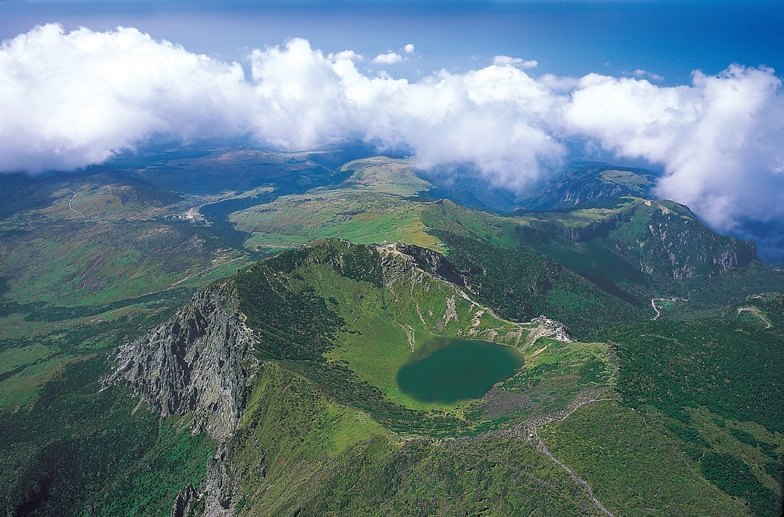
Ulleung Island, another volcanic island, lies off the east coast in the Sea of Japan; in general the volcanic islands get younger the further west they lie.
For more on the northern half of that route, see our guide to North Korea's mountains, rivers and plains, and for the capital at the other end of the Han, read about how Seoul sits in the Han River basin. The border itself has its own guide, the DMZ between North and South Korea, and the story of how the line came to be drawn is told in the historical geography of Korea's division.