
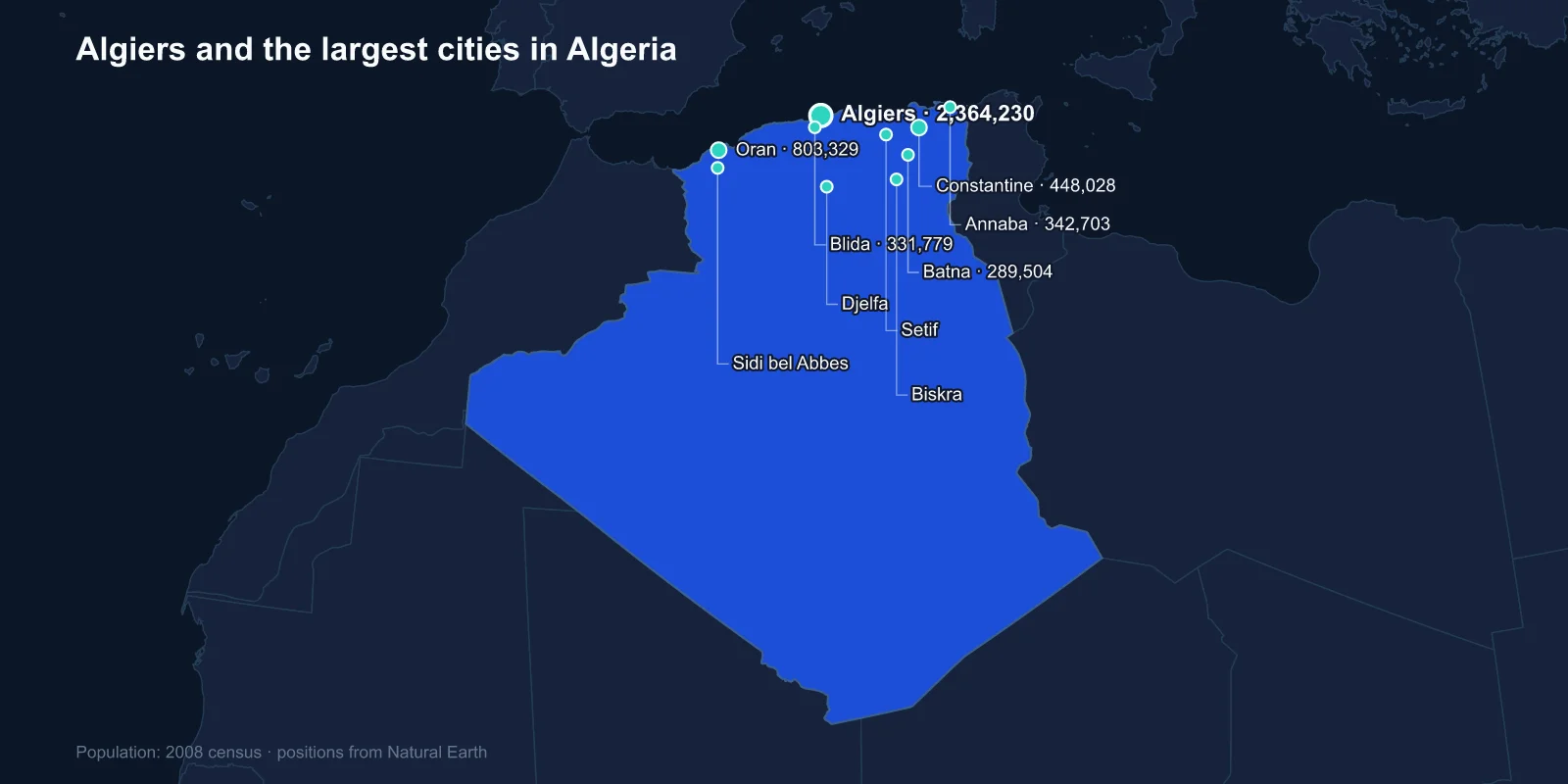
The largest cities in Algeria are Algiers (2,364,230), Oran (803,329), Constantine (448,028), Annaba (342,703), Blida (331,779), Batna (289,504), Djelfa (265,833), Setif (252,127), Sidi bel Abbes (210,146) and Biskra (204,661). These are 2008 census figures for the municipalities themselves; metropolitan populations are substantially larger, and Greater Algiers is usually put above three million.
The pattern behind the list is severe and easy to state. Algeria is the largest country in Africa at about 2.38 million square kilometres, and roughly nine-tenths of that is Sahara. Almost the entire population lives in a coastal band that is, in places, less than a hundred kilometres deep.
The Tell, and Everything Behind It
The habitable part of Algeria is the Tell — the coastal plains and the hills of the Tell Atlas, where Mediterranean rainfall makes farming possible. Behind it lie the high plateaux, semi-arid steppe used mainly for grazing, and behind those the Saharan Atlas and then the desert.
Every city in the top ten except Djelfa and Biskra sits in or just behind the Tell. Those two are the exceptions that prove the rule: Djelfa is a steppe town on the high plateau, and Biskra sits at the northern edge of the Sahara where the mountains give way to date palms.
The consequence is a population density that is meaningless as a national average. Calculated across the whole territory it looks empty; calculated across the strip where people actually live, it looks like southern Europe.
Algiers, the White City
Algiers climbs a steep amphitheatre of hills above a bay, and the whitewashed buildings stacked up that slope gave it the old name Alger la Blanche. The Casbah, the Ottoman-era citadel and the dense quarter below it, is a UNESCO World Heritage Site and an extraordinary piece of pre-modern urban design — a maze of stepped alleys built on a gradient that excludes wheeled traffic entirely.
It is also, unavoidably, a site of the Algerian War. The Battle of Algiers in 1956 and 1957 was fought in those alleys, and the French paratroopers' campaign there — including the systematic use of torture — became one of the defining episodes of decolonisation and the subject of Gillo Pontecorvo's film.
The French built a second city below and beside the Casbah, with arcaded boulevards along the seafront modelled on Haussmann's Paris. The two sit against each other, and the contrast is the clearest architectural statement of colonial rule anywhere in North Africa.
Oran and the Music It Exported
Oran, the second city, faces west towards Spain and has always been the more Mediterranean and less Ottoman of the two great ports. It was held by Spain for long stretches between 1509 and 1792, and the fortress of Santa Cruz still stands above it.
Its most durable export is musical. Rai grew in the bars and cabarets of Oran from the 1920s, fusing Bedouin song with whatever arrived through the port, and in the 1980s — amplified, electrified and carried to France by emigration — it became the most internationally successful popular music to come out of the Arab world.
Oran is also the setting of Albert Camus's The Plague, which opens by describing it as an ordinary town, thoroughly negative, with no pigeons and no trees. The city has never entirely forgiven him.
A City Built Across a Gorge
Constantine is the most spectacular site of any Algerian city. It stands on a rock plateau almost entirely encircled by the Rhumel gorge, a ravine up to 200 metres deep, and the only way to move around the city is across it.
The result is a town defined by bridges — the Sidi M'Cid suspension bridge, the Sidi Rached viaduct with its enormous stone arches, the footbridges strung over the chasm — which is why Constantine is universally known as the city of bridges.
It is also very old. As Cirta it was the capital of Numidia under Massinissa and Jugurtha, before the Romans rebuilt it and the emperor Constantine gave it his name in 313. Few cities have kept the same defensible rock for that long.
Annaba and the Bishop of Hippo
Annaba, on the eastern coast, is built beside the ruins of Hippo Regius, where Augustine served as bishop from 395 until his death in 430 while the Vandals besieged the city. The basilica on the hill above the ruins is named for him and remains a pilgrimage site.
Modern Annaba is an industrial port, dominated by the El Hadjar steel complex built in the 1960s as the centrepiece of post-independence industrialisation, and by phosphate exports from the Tebessa mines inland.
The Inland Cities and What They Do
Blida sits on the Mitidja, the fertile plain immediately behind Algiers, and is the centre of a citrus and market-garden region — the agricultural engine that fed the colonial economy and still supplies the capital.
Batna is the gateway to the Aures mountains, the Chaoui Berber heartland where the Algerian War began on 1 November 1954. Nearby are Timgad, the almost perfectly preserved Roman grid city founded by Trajan, and Lambaesis, the legionary fortress that guarded it.
Setif, on the high plains, carries a darker date. On 8 May 1945, as Europe celebrated the German surrender, a nationalist demonstration in Setif was fired on, and the reprisals that followed across the region killed thousands of Algerians. It is widely treated as the moment the war of independence became inevitable.
The Legion, the Dates and the Desert Edge
Sidi bel Abbes was the headquarters of the French Foreign Legion from 1843 until 1962, and the town was effectively built around the garrison. When the Legion left for Aubagne at independence it took its monuments and its dead with it.
Biskra, at the desert's edge, is a date-growing oasis city on the route south, long used as a winter resort and painted by a steady stream of European artists looking for the Sahara. Djelfa, on the steppe between the two Atlas ranges, is a sheep-market town and one of the few large Algerian cities with no coastal or mountain setting at all.
Tebessa and Skikda round out the larger centres. Tebessa sits near the Tunisian border on top of the phosphate deposits that feed Annaba's industry, and retains a remarkably complete set of Roman walls and a triumphal arch. Skikda is a petrochemical port, the terminal for gas liquefaction plants that helped make Algeria one of the first countries in the world to ship liquefied natural gas.
Kabylie, and the Cities That Are Not on the List
Two significant cities sit just outside the top ten, and both are Berber. Tizi Ouzou and Bejaia are the principal centres of Kabylie, the mountainous region east of Algiers where Tamazight rather than Arabic is the first language of most people.
Kabylie has a long record of political distinctiveness, from its resistance to French rule through to the Berber Spring of 1980 and the Black Spring of 2001, and the campaign for recognition of Tamazight succeeded only in 2016, when it became an official language of the state.
Their absence from the top ten is a matter of municipal boundaries and mountain terrain rather than of regional importance. Kabylie is densely populated, but its population is spread across many villages on steep ground rather than concentrated into one large city.
The New Towns Built to Take the Overflow
Algeria's response to its housing shortage has been to build satellite cities outright. Ali Mendjeli, laid out on the plateau outside Constantine from the 1990s, now houses well over a hundred thousand people and functions as a city in its own right, though it is counted separately from Constantine.
Similar developments ring Algiers — Sidi Abdellah to the west, and the vast apartment blocks at Bab Ezzouar and Rouiba to the east. Much of it was financed directly from hydrocarbon revenue during the high-price years of the 2000s, and it is the physical form that oil money took in a country that chose to spend it on housing rather than on visible prestige projects.
Where the Oil and Gas Actually Are
There is an obvious absence from this list. Algeria's economy runs on hydrocarbons — it holds some of the largest natural gas reserves in Africa — and none of the production is anywhere near the cities.
Hassi Messaoud, the main oil field, and Hassi R'Mel, the great gas field, sit deep in the Sahara hundreds of kilometres from the coast, served by pipelines and by fly-in workforces rather than by towns of any size. The revenue lands in Algiers; the resource is in the emptiest part of the country.
That split — population on the coast, wealth under the desert — is the structural fact of modern Algeria, and it is why the city list looks so unrelated to the economy that funds it.
Ninety Per Cent of the Country Is Empty
Algeria's cities trace the habitable margin of an enormous country: Ottoman and Roman ports along the Mediterranean, a ring of market towns behind them in the Tell, two outliers on the steppe and the desert edge, and nothing at all in the ninety per cent of the territory that is Sahara.
The Sahara that occupies most of the territory, and the Atlas ranges that fence the cities off from it, are covered in our Algeria country guide. The Algiers profile goes into the Casbah and the colonial city below it, and Algeria’s place in North Africa explains the coastline they all share.
