
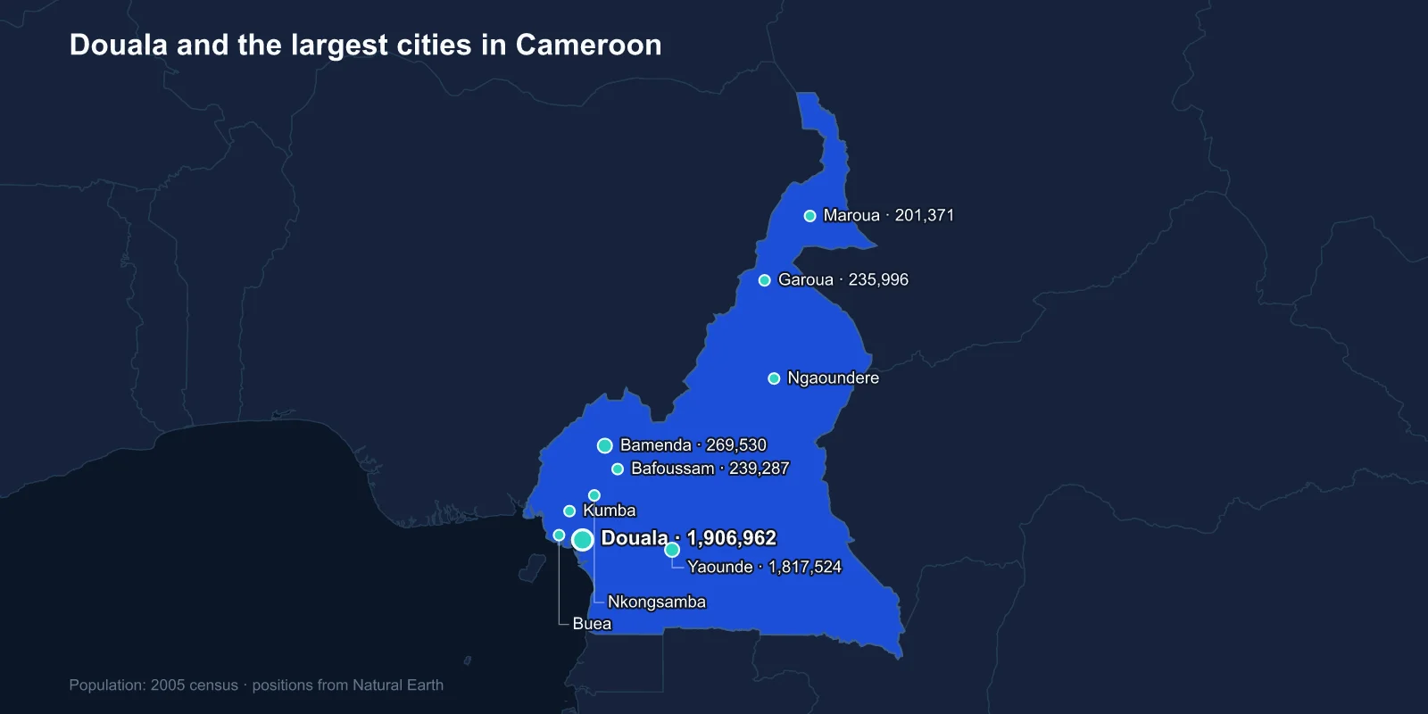
The largest cities in Cameroon are Douala (1,906,962), Yaounde (1,817,524), Bamenda (269,530), Bafoussam (239,287), Garoua (235,996), Maroua (201,371), Ngaoundere (152,698), Kumba (144,268), Nkongsamba (104,050) and Buea (90,090). These are 2005 census figures, the last full count; current estimates put both of the leading cities between three and four million.
Cameroon is one of very few countries where the two largest cities are effectively tied. Douala led Yaounde by under five per cent in 2005, and which of them is first today depends on who is counting and where the boundary is drawn.
The Port and the Government
Douala sits on the Wouri estuary and is the economic capital by every measure. Its port handles the overwhelming majority of Cameroonian trade and serves Chad and the Central African Republic as well, which makes it one of the most important harbours in the region.
Yaounde, about 200 kilometres inland on a set of forested hills, is the political capital. It was established by German officers in 1888 as a trading and research station, and it became the administrative seat because its altitude made it healthier than the coast — the same logic that placed so many colonial capitals off the malarial shoreline.
The rivalry between the two is a running feature of national life, expressed most visibly through football and most consequentially through arguments about infrastructure spending. Neither city has ever absorbed the other's function.
A Country Assembled From Three Colonies
Cameroon's defining peculiarity is that it was colonised three times. Germany held Kamerun from 1884 until the First World War, when the territory was taken and divided between France and Britain as League of Nations mandates.
French Cameroun became independent in 1960. British Cameroons was split by a plebiscite in 1961: the northern part joined Nigeria, and the southern part joined the new republic, creating a federation of a francophone majority and an anglophone minority with different legal systems, school systems and administrative traditions.
The federation was abolished in 1972 in favour of a unitary state, a move anglophones have contested ever since as the erasure of the terms on which they joined.
Bamenda, Buea and the Anglophone Crisis
Bamenda is the third-largest city and the principal centre of the North-West Region; Buea, tenth, is the capital of the South-West and was the capital of German Kamerun, sitting on the slopes of Mount Cameroon. Both are anglophone.
In late 2016 lawyers and teachers in both cities went on strike over the appointment of francophone magistrates to common-law courts and francophone teachers to English-language schools. The protests were suppressed, the demands hardened into separatism, and by 2017 an armed conflict had begun over a claimed state of Ambazonia.
The war that followed has displaced hundreds of thousands of people, closed schools across both regions for years at a time, and emptied parts of Bamenda and Buea. Any population figure for the anglophone cities from before 2016 describes a different place.
Mount Cameroon Sits Right Behind the Coast
Buea's setting is dramatic. Mount Cameroon rises to 4,040 metres directly from the Atlantic, the highest point in West and Central Africa and one of the continent's most active volcanoes, with eruptions recorded roughly every couple of decades — 1999 and 2000 among the most recent.
The mountain's south-west flank at Debundscha receives among the highest rainfall totals anywhere in the world, in the order of ten metres a year. The volcanic soils support the plantations of the Cameroon Development Corporation, historically one of the largest employers in the country, growing bananas, rubber, oil palm and tea.
Africa in Miniature
Cameroon is often described as Africa in miniature, and the phrase is justified by the range of landscape packed into it. The south is Congo Basin rainforest; the west is volcanic highland; the centre is plateau; the north runs into Sahelian savanna and then to Lake Chad.
The city list follows that gradient exactly. Douala and Kumba sit in the coastal forest, Bafoussam and Bamenda in the western highlands, Yaounde on the central plateau, Ngaoundere on the Adamawa escarpment, and Garoua and Maroua out on the northern plains.
That is close to a thousand kilometres from end to end, across climates that have almost nothing in common, and the cultural distance matches it — Cameroon has somewhere around 250 languages, one of the highest counts in Africa.
The Northern Cities and the Benue
Garoua, fifth on the list, sits on the Benue river, which is navigable downstream to Nigeria for part of the year. It was a river port for exactly that reason, shipping cotton and groundnuts down to the Niger, and it is the largest city of the predominantly Muslim, Fulani north.
Maroua, further north in the Far North Region, is the market town for the Mandara mountains and the Lake Chad basin. Both cities have been affected by Boko Haram, which has operated across the Nigerian border into the Far North since 2014 and displaced large numbers of people towards Maroua.
Ngaoundere, on the Adamawa plateau between north and south, is the terminus of the railway from Douala and Yaounde, which makes it the transhipment point for everything moving on to Chad by road.
That road is one of the busiest lorry corridors in Central Africa, and it is the reason Chadian and Central African trade depends on Cameroonian stability. When the anglophone conflict or unrest in the far north closes a section of it, the effects are felt in N'Djamena and Bangui within days.
Bafoussam and the Grassfields
Bafoussam is the largest city of the Bamileke grassfields in the west, a densely populated volcanic highland region divided among a great many small chiefdoms, each with its own palace and ruler.
The Bamileke have an outsized commercial presence in Cameroon, and their trading networks run through Douala and Yaounde and out across the region. The area is also the centre of a distinctive architectural and craft tradition, with carved and beaded thrones, elaborate masks and conical thatched palace buildings.
Bafoussam sits close to Cameroon's crater lakes, and one of them produced a disaster with no real precedent. In August 1986 Lake Nyos, about 100 kilometres north, released an enormous cloud of carbon dioxide that had accumulated in its depths. The gas flowed downhill and suffocated roughly 1,700 people and their livestock in the valleys below.
A degassing pipe was installed in 2001 to vent the lake continuously. The event gave science the term limnic eruption, and only three lakes in the world are known to be capable of one — two of them in Cameroon.
Kumba, Nkongsamba and the Plantation Towns
Kumba, eighth, is the largest town of the South-West interior and the market centre for a forest region of oil palm and cocoa smallholdings. It has been one of the towns most disrupted by the anglophone conflict, with schools closed for extended periods and a weekly ghost-town shutdown enforced by separatists.
Nkongsamba, ninth, was once the third-largest city in Cameroon. It sat at the end of the colonial railway from Douala and grew as the collection point for coffee from the Moungo valley. The line closed, coffee prices fell, and the town has been in relative decline ever since — the clearest example in the country of a city whose size was entirely a function of a railhead.
Where the Football Comes From
Cameroon's international standing owes a great deal to football, and the sport maps onto these cities in a specific way. Douala and Yaounde host the historic clubs — Union Douala, Canon Yaounde, Tonnerre Yaounde — whose rivalry is the sharpest expression of the two cities' competition.
The national team's run to the quarter-finals at the 1990 World Cup, the first African side to get that far, changed how the continent was seeded in the tournament. When Cameroon hosted the Africa Cup of Nations in 2021 and 2022, the stadium programme spread new construction to Bafoussam, Garoua and Limbe, which is one of the few recent instances of major infrastructure reaching the secondary cities on this list.
Why the Census Is Twenty Years Old
Cameroon's last census was conducted in 2005. A fourth general census was launched and has been repeatedly delayed, and the published projections for intervening years are erratic enough to be unusable — projecting some towns to shrink by half while others quadruple.
The 2005 figures are therefore the most defensible basis for a ranking, even though they are demonstrably out of date. What has certainly changed is the scale: both leading cities have roughly doubled, and the anglophone crisis and the Boko Haram insurgency have redistributed people in the north-west and far north in ways no projection anticipated.
One Country, Three Colonial Inheritances
Cameroon's cities run the length of a country that contains most of Africa's landscapes and three colonial inheritances: a port and a capital of almost identical size, two anglophone cities at the centre of an armed conflict, a highland trading region, and a string of Sahelian towns at the far end of a railway.
Our Cameroon country guide covers the full gradient from Congo Basin rainforest to the Lake Chad plains, which is really what this list is measuring. The Yaounde profile takes the political half of the pair, and the divide these cities sit across is set out in Cameroonian religious life.
