
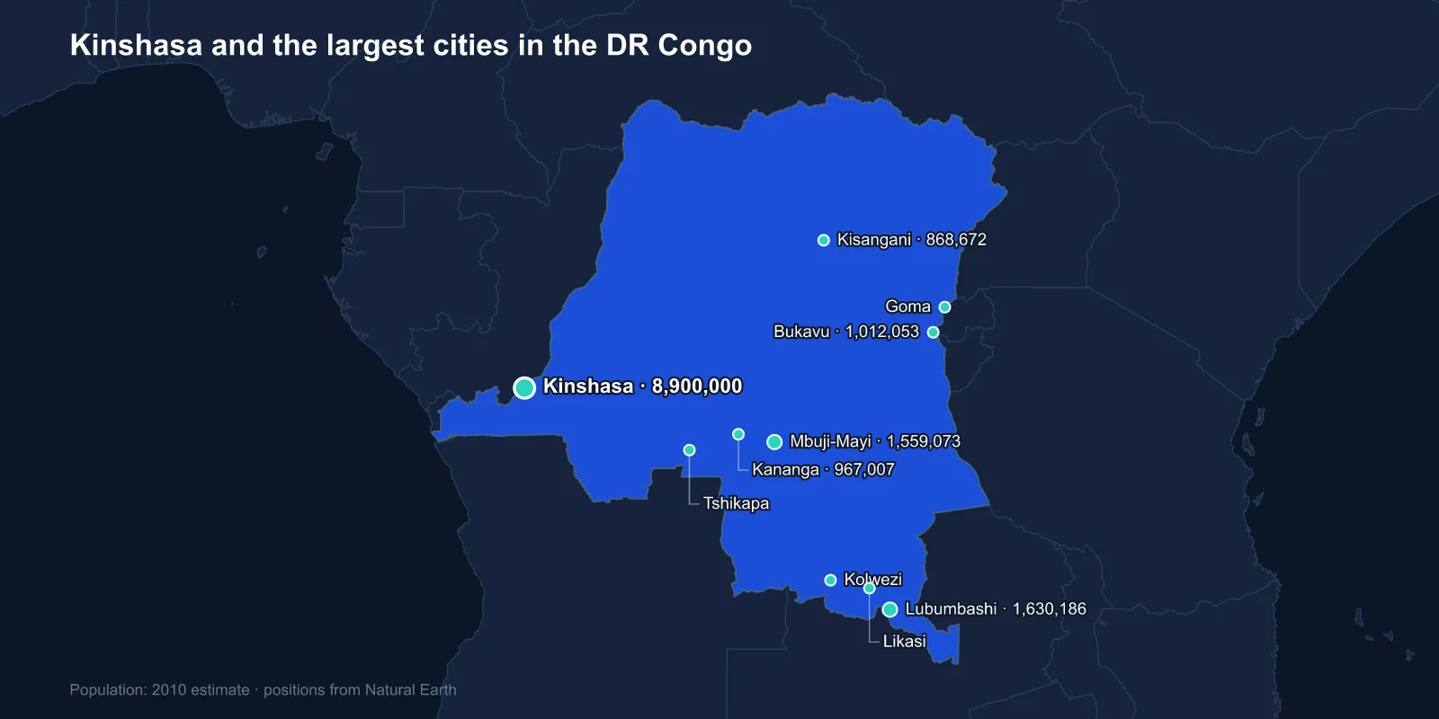
The largest cities in the Democratic Republic of the Congo are Kinshasa (about 8,900,000), Lubumbashi (1,630,186), Mbuji-Mayi (1,559,073), Bukavu (1,012,053), Kananga (967,007), Kisangani (868,672), Tshikapa (524,293), Kolwezi (451,168), Likasi (422,535) and Goma (377,112). Those are 2010 estimates, and they are the most recent comprehensive set available: the DR Congo has not held a census since 1984.
Read them as a snapshot of a country that has since added tens of millions of people. Current estimates put Kinshasa somewhere between fourteen and seventeen million, which would make it one of the largest cities on the planet and comfortably the biggest in Africa after Lagos and Cairo.
Two Capitals Staring at Each Other
Kinshasa sits on the south bank of the Congo at Malebo Pool, the wide lake-like stretch where the river slows before plunging through the cataracts to the sea. On the north bank, about four kilometres away, is Brazzaville, capital of the neighbouring Republic of the Congo.
They are the closest pair of capital cities in the world, close enough to see one another across the water, and yet there is no bridge. Crossing requires a ferry and a border formality, and a long-discussed road-rail bridge has never been built. Two national capitals within sight of each other, joined only by boat, is a situation with no real parallel anywhere.
The city was founded in 1881 by Henry Morton Stanley, working for Leopold II of Belgium, and named Leopoldville. At independence in 1960 it held roughly 400,000 people. The multiplication since is among the fastest sustained urban expansions in recorded history, and it happened with very little of the infrastructure investment that usually accompanies it.
The Mining Cities of the South
Four of the ten largest cities sit in the copper and cobalt belt of the former Katanga, and they exist because of what is under them.
Lubumbashi was founded in 1910 as Elisabethville to serve the copper mines, and it remains the country's industrial capital, closer to Zambia and South Africa than to Kinshasa in both distance and economic orientation. Likasi and Kolwezi are smaller versions of the same story. Kolwezi in particular sits at the centre of the world's cobalt supply, a metal that moved from obscurity to strategic importance as lithium-ion batteries became a mass product.
Mbuji-Mayi, third on the list, is a diamond city. It grew explosively in the second half of the twentieth century around the industrial and artisanal diamond fields of Kasai, and it is often cited as one of the least accessible large cities anywhere — a million-plus urban area with poor road links in every direction, supplied largely by air and by informal trade.
A Country Where the River Is the Road
The single most important fact about Congolese geography is that the country is roughly the size of Western Europe and has almost no functioning long-distance road network. You cannot reliably drive from Kinshasa to Lubumbashi. For much of the country, the Congo River and its tributaries are the transport system, as they have been since before the colonial period.
Kisangani, sixth on the list, marks the head of navigation. Above it the river is broken by Boyoma Falls, a chain of seven cataracts that stops boats, which is exactly why a city grew at that point. Stanley reached it in 1877 and it was known as Stanleyville until 1966.
That dependence explains the shape of the urban system. Congolese cities are not nodes on a network; they are islands, each connected to its own hinterland and to the outside world, but weakly connected to one another. It is part of why regional identity is so strong and why control of the east has been contested for three decades.
The Eastern Cities and the Volcano
Bukavu and Goma sit at opposite ends of Lake Kivu on the Rwandan border, and both have been at the centre of the conflicts that followed the 1994 Rwandan genocide. Their populations swelled with refugees and displaced people on a scale that makes any official figure a rough guide at best.
Goma has an additional problem: it is built on the flank of Nyiragongo, an active volcano with one of the world's few persistent lava lakes. Nyiragongo's lava is unusually fluid, low in silica, and can run downhill faster than a person can move. An eruption in January 2002 sent lava through the centre of the city and destroyed a large part of it. A second eruption in May 2021 killed dozens and forced a mass evacuation.
A city of several hundred thousand people sitting directly below an active lava lake is an extraordinary piece of urban geography, and it persists because Goma is the commercial gateway to the eastern provinces and people have nowhere else to go.
The Sound the Capital Exports
Kinshasa's cultural reach is far larger than its economic weight. Congolese rumba, which grew in the bars of Leopoldville and Brazzaville from the 1940s by way of Cuban records that were themselves descended from Congolese rhythms carried across the Atlantic, became the dominant popular music of central Africa and much of the continent beyond it.
UNESCO added Congolese rumba to its list of intangible cultural heritage in 2021. The soukous guitar styles that followed it, and the artists who worked them, gave Kinshasa an influence over African popular culture that no Congolese industry has ever matched.
The city is also overwhelmingly informal. Estimates of the share of Kinshasa's workforce outside registered employment run from two-thirds upwards, and the markets, transport and construction that keep a city of this size functioning operate almost entirely outside the formal tax system. This is part of why economic statistics for the DR Congo understate what actually moves through its largest city.
Why the Figures Are Four Decades Stale
The last Congolese census was conducted in 1984, when the country was still Zaire and held around thirty million people. Everything since is projection. Repeated attempts to organise a new count have been defeated by cost, by the sheer difficulty of reaching much of the territory, and by the political stakes — population determines parliamentary representation, and in a country with this many regional tensions, a recount is never just arithmetic.
The practical consequence is that the ordering of cities is more trustworthy than the numbers attached to them. Kinshasa is unquestionably first by an enormous margin; Lubumbashi is second; the middle of the table is genuinely uncertain, and cities such as Tshikapa and Uvira may well have overtaken others since the estimates were made.
A City Built in Two Halves
Kinshasa still carries the shape colonial planning gave it. The Belgian administration divided Leopoldville into the ville, the European quarter along the river with wide boulevards and services, and the cite, the African quarters laid out behind it, separated for much of the period by a deliberate buffer strip.
That division survived independence as an economic one. The riverside communes still hold the ministries, the university and the embassies; the vast majority of Kinois live in the outer communes, many of them built on steep, sandy hillsides that were never intended for dense settlement.
The result is an erosion problem that gets worse each rainy season. Heavy rain cuts ravines through unpaved neighbourhoods, and floods in the city have repeatedly killed dozens of people in a single night. It is a reminder that the most pressing geography in a fast-growing city is often not its site on a map but the slope of the ground under its newest districts.
Kananga, Tshikapa and the Kasai Interior
Kananga, formerly Luluabourg, is the administrative centre of the Kasai region and was briefly considered as a possible national capital in the early 1960s. Tshikapa, downstream on the Kasai River, is another diamond town, close to the Angolan border and deeply tied to cross-border trade.
Both were badly affected by the Kamuina Nsapu insurgency that ran through Kasai from 2016, an episode that displaced well over a million people and that received a fraction of the international attention given to the eastern conflicts. Urban populations in the region absorbed much of that displacement.
Uvira, on the northern tip of Lake Tanganyika and directly across from Bujumbura, rounds out the larger centres and illustrates the same pattern as Goma and Bukavu: a border city whose size is driven as much by movement of people fleeing conflict as by any local economy.
What This List Actually Describes
The Congolese urban ranking is a map of resources and rivers rather than of administration. Diamonds built Mbuji-Mayi and Tshikapa, copper and cobalt built Lubumbashi, Likasi and Kolwezi, the limit of navigation built Kisangani, and a colonial trading post at the head of the cataracts became one of the largest cities in the world.
What almost none of them share is a road to each other, which is why the Congo River matters more to Congolese cities than any highway. Kinshasa gets its own profile, and the basin the whole country sits in is covered in our DR Congo country guide.
