
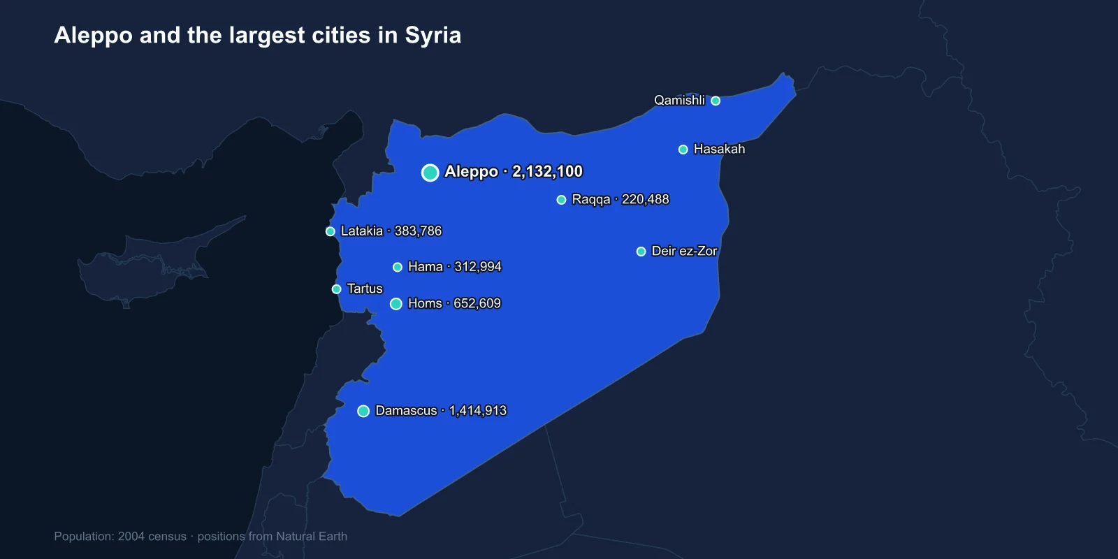
The largest cities in Syria are Aleppo (2,132,100), Damascus (1,414,913), Homs (652,609), Latakia (383,786), Hama (312,994), Raqqa (220,488), Deir ez-Zor (211,857), Hasakah (188,160), Qamishli (184,231) and Tartus (115,769). These are 2004 census figures — the last complete national count Syria has conducted.
That date matters more here than in any other country in this series. The war that began in 2011 displaced more than half the pre-war population, and the cities on this list have been besieged, bombarded and depopulated to degrees that vary enormously between them.
Aleppo Was Bigger Than the Capital
It surprises many people that Damascus was not Syria's largest city. Aleppo was, and it had been the commercial heart of the country for centuries — a caravan city at the western end of the routes from Mesopotamia and Persia, with a covered souk running for kilometres and a citadel on a mound above it that is among the oldest and largest castles in the world.
Aleppo's old city was a UNESCO World Heritage Site. Between 2012 and 2016 the front line ran directly through it. The Great Mosque's eleventh-century minaret was destroyed in 2013, much of the covered souk burned, and the eastern districts were subjected to a siege and aerial campaign that ended with their capture in December 2016.
The city's manufacturing base — textiles, pharmaceuticals, food processing, which together made Aleppo Syria's industrial centre — was largely dismantled, in part by machinery being removed across the Turkish border and sold.
The Oldest Continuously Inhabited City
Damascus has a reasonable claim to being the longest continuously inhabited city on earth, with settlement evidence going back several thousand years. The Umayyad Mosque was built in the early eighth century on a site that had been a Roman temple to Jupiter and then a Christian basilica, and the street called Straight is named in the Book of Acts.
The capital was comparatively protected during the war. The centre remained under government control throughout, while the suburbs — Eastern Ghouta, Darayya, Yarmouk — were besieged for years and reduced to ruins within sight of intact neighbourhoods.
Yarmouk, the Palestinian refugee camp that had become a dense district of the city, held well over 100,000 people before 2011 and a few hundred by 2018. Sayyidah Zaynab, which appears in the 2004 top twelve, grew around a shrine important to Shia pilgrims and became a base for Iranian-aligned militias during the war.
Homs, Hama and the Corridor
Homs sits at the only real gap in the mountain range that separates the Syrian interior from the Mediterranean, which has made it strategically decisive for as long as there have been armies in the region. The road from Damascus to Aleppo and the road to the coast both pass through it.
The city was an early centre of the 2011 uprising and was besieged from 2011 to 2014, with the old city districts almost entirely destroyed before a negotiated evacuation of fighters.
Hama, to the north, carried an older memory. In February 1982 the government of Hafez al-Assad suppressed a Muslim Brotherhood rising there by shelling the city, killing somewhere between ten and forty thousand people. The episode shaped how both the government and the opposition understood what was possible, and Hama was comparatively quiet after 2011 as a result.
The Coast Stayed Intact
Latakia and Tartus, the two coastal cities, came through the war far better than any others. They are the heartland of the Alawite community from which the Assad family came, and they remained firmly under government control.
Both host foreign military facilities: Russia's naval base at Tartus, its only Mediterranean port, and the Hmeimim air base outside Latakia, from which the Russian intervention from 2015 was flown.
The coast absorbed a substantial internal displacement from the interior, and its population is now well above the 2004 figures — one of the few parts of the list where the numbers understate rather than overstate.
Raqqa and Deir ez-Zor on the Euphrates
Raqqa was a provincial city on the Euphrates, historically significant as Harun al-Rashid's residence in the late eighth century, and unremarkable in the modern period until 2014, when the Islamic State made it the capital of its claimed caliphate.
The campaign to retake it in 2017 by the Syrian Democratic Forces with American air support destroyed the great majority of the city. Damage assessments after the battle found a large proportion of buildings damaged or destroyed, and unexploded ordnance made return slow and dangerous.
Deir ez-Zor, further downstream, was divided and besieged for three years, and the province around it holds most of Syria's modest oil production — control of those fields has been a persistent point of friction since.
The Kurdish North-East
Hasakah and Qamishli are the principal cities of the north-east, a region with a large Kurdish population alongside Arabs, Assyrians and Armenians. Qamishli sits directly on the Turkish border, facing Nusaybin, and was largely created in the 1920s as a settlement for Christians fleeing Turkey.
From 2012 Kurdish forces established de facto autonomy across the region, which became the Autonomous Administration of North and East Syria. Its relationship with the government in Damascus, with Turkey and with the United States has remained unresolved, and Turkish operations in 2018 and 2019 displaced substantial populations along the border strip.
The region is agriculturally important — it is where most Syrian wheat and cotton is grown — and severe drought in the 2000s, which pushed farming families off the land and into the cities, is widely cited as one of the pressures behind the 2011 unrest.
The drought argument should be handled carefully. The link between the 2006 to 2010 dry years, rural migration and the uprising has been asserted widely and also contested by researchers who argue the migration figures were overstated and that agricultural policy mattered more than rainfall. What is not disputed is that the north-eastern countryside lost population to the cities in the years immediately before 2011.
The Dead Cities and the Crusader Castles
Between Aleppo and Idlib sits one of the strangest archaeological landscapes in the world: several hundred abandoned Byzantine settlements, known collectively as the Dead Cities, standing in limestone hills with their houses, churches, olive presses and tombs largely intact and roofless.
They were prosperous olive-oil towns in the fourth to seventh centuries and were left rather than destroyed, as trade routes shifted after the Arab conquests. Inscribed by UNESCO in 2011, they were used as shelter by displaced families during the war.
Further south stands Krak des Chevaliers, generally considered the best-preserved Crusader castle anywhere, which was shelled and then taken in 2014. Syria holds six World Heritage Sites, and all six were placed on the List of World Heritage in Danger in 2013.
Palmyra, and What Was Deliberately Destroyed
Palmyra was a caravan city in the desert between Damascus and the Euphrates, a Roman-era trading power whose colonnaded street, temples and tower tombs stood for nearly two thousand years. Its queen Zenobia briefly ruled an empire from it in the 270s.
The Islamic State took the site in 2015 and destroyed the Temple of Bel, the Temple of Baalshamin, the monumental arch and several tower tombs, and publicly murdered Khaled al-Asaad, the archaeologist who had directed the site for four decades and refused to reveal where artefacts had been moved.
The modern town beside the ruins, Tadmur, was largely emptied. Its other institution was the military prison, notorious for the 1980 massacre of prisoners and closed after the site changed hands.
What the Numbers Cannot Show
Before 2011 Syria's population was around 21 million. The war produced more than six million refugees abroad, predominantly in Turkey, Lebanon and Jordan, and a comparable number displaced inside the country.
Return has been partial and uneven, and it accelerated after the fall of the Assad government in December 2024. But return to a city is not the same as return to a home: large parts of Aleppo, Homs, Raqqa and the Damascus suburbs have no habitable housing, no reliable power and no water network.
Any figure in this list is therefore a record of the pre-war distribution. Reading it alongside what happened to each city afterwards is the only honest way to use it.
A further complication is that the 2004 figures count cities rather than metropolitan areas. Damascus proper was recorded at 1.4 million, but the built-up area including Rural Damascus governorate held well over four million before the war — which is the number to use when comparing the capital with Aleppo or with cities in other countries.
An Old and Unusually Balanced Network
Syria's cities describe an old and unusually balanced urban system: a commercial capital in the north larger than the political one, a gap city controlling the route to the sea, two coastal ports, and a line of towns along the Euphrates and the Turkish border.
The communities these cities are divided among are described in Syrian religious life, which is the best way to read what happened to each of them after 2011. The Damascus profile covers the older capital, and the coast, mountains and desert in our Syria country guide.
