
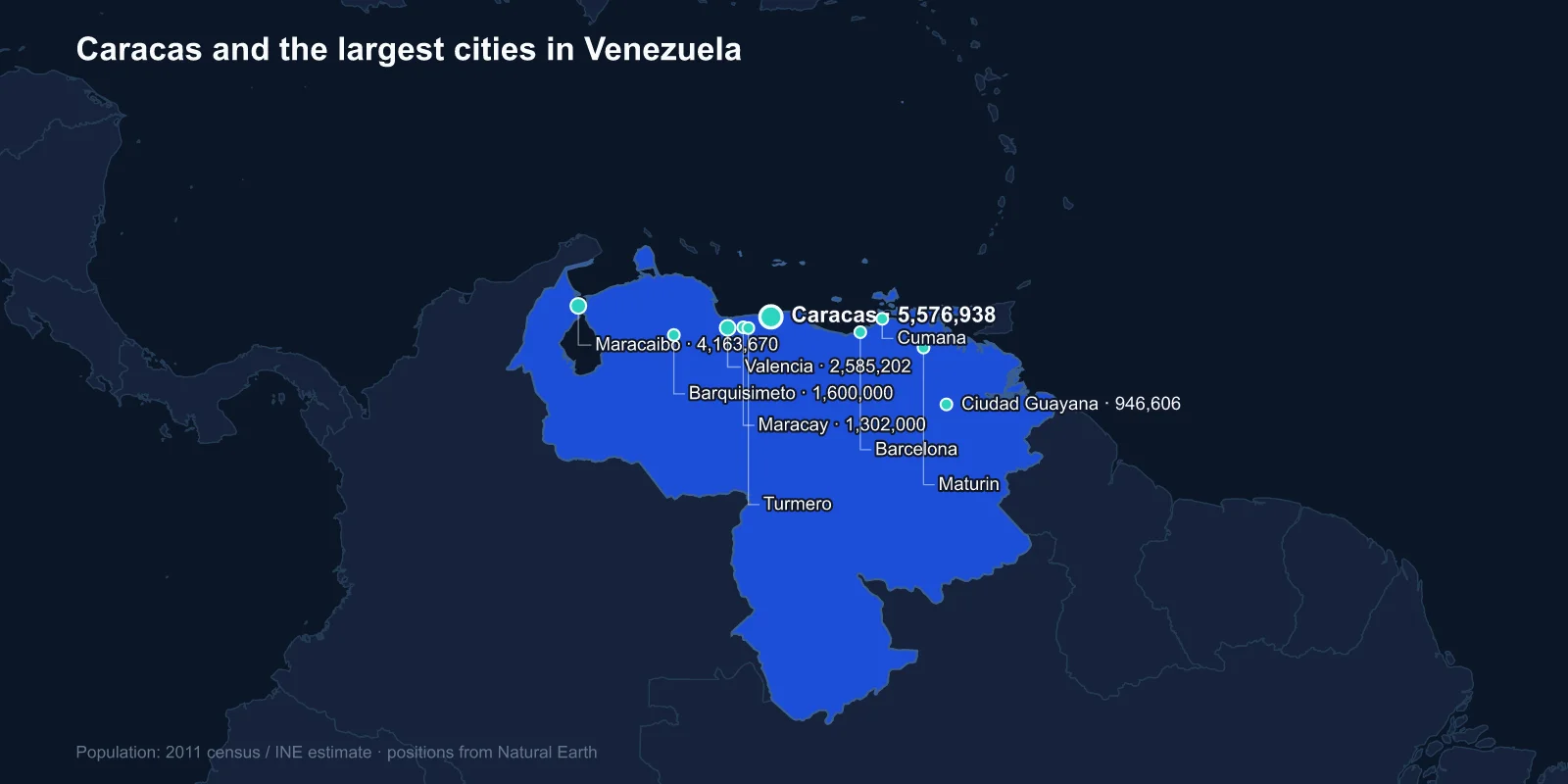
The largest cities in Venezuela are Caracas (about 5,576,938 in the metropolitan area), Maracaibo (4,163,670), Valencia (2,585,202), Barquisimeto (1,600,000), Maracay (1,302,000), Ciudad Guayana (946,606), Barcelona (750,000), Maturin (410,967), Cumana (374,706) and Turmero (344,746). These are census-based estimates anchored on the 2011 count, the last completed national census.
They describe a country before its collapse. Since 2014 something in the order of seven to eight million Venezuelans have left — close to a quarter of the population — in one of the largest displacement crises in the world, and every city on this list is smaller than its figure suggests.
A Capital in a Valley That Ran Out of Room
Caracas sits in a narrow east-west valley at about 900 metres, separated from the Caribbean by the Avila massif, a steep coastal range that rises above 2,600 metres directly behind the city.
That setting gives the capital a pleasant climate for its latitude and an insoluble geometry. The valley floor filled long ago, and the city expanded up the surrounding hillsides in barrios — self-built neighbourhoods on slopes too steep for conventional construction, reached by stairs and, since 2010, by cable cars installed as public transport.
The separation from the sea is absolute enough that reaching the airport and the port at La Guaira requires crossing the mountain. The motorway through it includes a viaduct that failed in 2006 and had to be replaced at emergency speed, cutting the capital off from its own coast for months.
The Lake That Made the Country Rich
Maracaibo, the second city, sits at the neck of Lake Maracaibo, a vast brackish inlet connected to the Gulf of Venezuela by a narrow strait. The lake is the reason modern Venezuela exists in the form it does.
The Barroso well blew out near Cabimas in 1922 and flowed at a rate that announced the Maracaibo basin as one of the great oil provinces of the world. Within a decade Venezuela was the largest oil exporter on earth, and the country's economy, politics and urban growth have been organised around that fact ever since.
The lake is crossed by the General Rafael Urdaneta Bridge, more than eight kilometres long, opened in 1962. Above the lake's southern end, where the Catatumbo river enters it, lightning strikes with a frequency recorded nowhere else — the Catatumbo lightning is active most nights of the year and has been used as a navigation aid for centuries.
The Industrial Corridor West of the Capital
Valencia, Maracay and Turmero form a chain along the highway between Caracas and the west, in the Aragua and Carabobo valleys. This was the country's manufacturing belt — car assembly, food processing, chemicals, textiles — built up during the import-substitution decades when oil revenue financed domestic industry.
Valencia in particular became Venezuela's industrial capital, with plants operated by international manufacturers serving the domestic market. Most of that capacity has since closed or run at a fraction of its output, as currency controls, expropriations and the collapse in purchasing power removed both the inputs and the customers.
Barquisimeto, fourth on the list, sits further west and is the commercial centre for the Andean foothills and the agricultural states behind them.
It is also the country's musical capital in a specific institutional sense. Venezuela's Sistema, the publicly funded network of youth orchestras founded by Jose Antonio Abreu in 1975, built some of its strongest nuclei there, and the programme has enrolled hundreds of thousands of children across every city on this list. Gustavo Dudamel came out of it, and it has been copied in dozens of countries.
Maracay, between Valencia and the capital, holds the main air force base and a military academy, and it was Juan Vicente Gomez's preferred seat of government in the 1910s and 1920s — which is why a provincial city has a bullring modelled on Seville's and an opera house.
A City Built for Steel
Ciudad Guayana is the most deliberate creation on the list. It was established in 1961 at the confluence of the Caroni and the Orinoco, merging the old town of San Felix with the new settlement of Puerto Ordaz, and it was planned with technical assistance from MIT and Harvard as a model development project.
The logic was resource-based: iron ore from Cerro Bolivar, bauxite nearby, and enormous hydroelectric potential on the Caroni. The Guri Dam, completed in stages through to 1986, is among the largest hydroelectric installations in the world and at times supplied the majority of Venezuela's electricity.
That concentration became a national vulnerability. When drought lowered the reservoir and maintenance lapsed, the failures at Guri produced country-wide blackouts — most severely in March 2019, when much of Venezuela lost power for days.
Where the Oil Moved To
Maturin and the eastern cities grew with the shift of the industry east to the Orinoco Belt, a band of extra-heavy crude north of the river that holds what are generally assessed as the largest proven oil reserves of any country in the world.
That superlative sits awkwardly beside the collapse in production. Venezuelan output fell from more than three million barrels a day in the late 1990s to a fraction of that, as investment, expertise and maintenance drained away. The heavy crude requires upgrading before it can be refined, and the upgraders largely stopped working.
Barcelona and neighbouring Puerto La Cruz on the north-east coast are the refining and port centres for that eastern production, and Cumana beside them is among the oldest continuously inhabited European-founded cities on the American mainland, established in 1515.
The Emigration Changed Every Number Here
From around 2014 the combination of hyperinflation, shortages of food and medicine, collapsing public services and political repression produced an exodus with no precedent in the region's peacetime history.
Colombia has received the largest share, with Peru, Brazil, Chile, Ecuador and the United States taking substantial numbers, and many have crossed the Darien Gap on foot. Inflation peaked at rates that made the currency functionally worthless, and the bolivar has been redenominated three times, removing fourteen zeros in total.
The effect on cities has not been even. Border states and the poorer interior lost proportionally more people than Caracas, where the partial dollarisation of the economy from 2019 created a visible enclave of restaurants and imported goods in the eastern districts, alongside districts with no reliable water or power.
The Mountain, the Falls and the Cities That Do Not Reach Them
Venezuela's most famous landscapes have no cities near them at all. Angel Falls, the highest uninterrupted waterfall in the world at 979 metres, drops from Auyan-tepui in the Gran Sabana, reachable only by light aircraft and river boat from Canaima.
The tepuis themselves — flat-topped sandstone table mountains rising sheer from the forest, some of the oldest exposed rock on earth — occupy a large part of the south-east and support a handful of Pemon villages rather than towns.
South of the Orinoco is close to half the country's land area and a very small share of its population, which is why every city on this list sits north of the river or on it.
The Slides That Buried La Guaira
In December 1999, after weeks of rain, the slopes of the Avila above the coastal strip north of Caracas gave way. Debris flows swept through the towns of Vargas state, burying parts of La Guaira and Caraballeda under metres of boulders and mud.
The death toll has never been established with confidence; estimates run from several thousand into the tens of thousands, and whole neighbourhoods were removed from the map. It remains one of the deadliest landslide events of the twentieth century, and it happened within sight of the capital's airport.
Why There Has Been No Census
The 2011 census is the last completed count. One scheduled for 2021 was postponed, and the conditions for conducting one — a stable population, functioning local administration, public trust in the statistics office — have not existed since.
The Venezuelan statistical institute stopped publishing much of its routine output during the crisis years, including inflation data, and independent estimates of the national population now vary by several million depending on assumptions about how many people have left and how many have returned.
What this means for a city ranking is that the order is probably still broadly right, and the magnitudes are not.
There is also a return flow that complicates any correction. Hundreds of thousands of Venezuelans have come back at various points, driven by conditions in host countries rather than by improvement at home, and the partial dollarisation has drawn some migrants back to Caracas specifically. Net figures conceal a great deal of movement in both directions.
Cities That Oil Built
Venezuela's cities were built by oil: a capital wedged in a coastal valley, a lake city where the industry began, an industrial corridor that has largely stopped, a planned steel city on the Orinoco, and eastern ports serving reserves that are the largest in the world and barely produced.
The Andes, the llanos and the Orinoco that frame all of this are covered in our Venezuela country guide. The Caracas profile looks at the valley the capital could not grow out of, and the traditions these cities share appear in Venezuelan religious life.
