
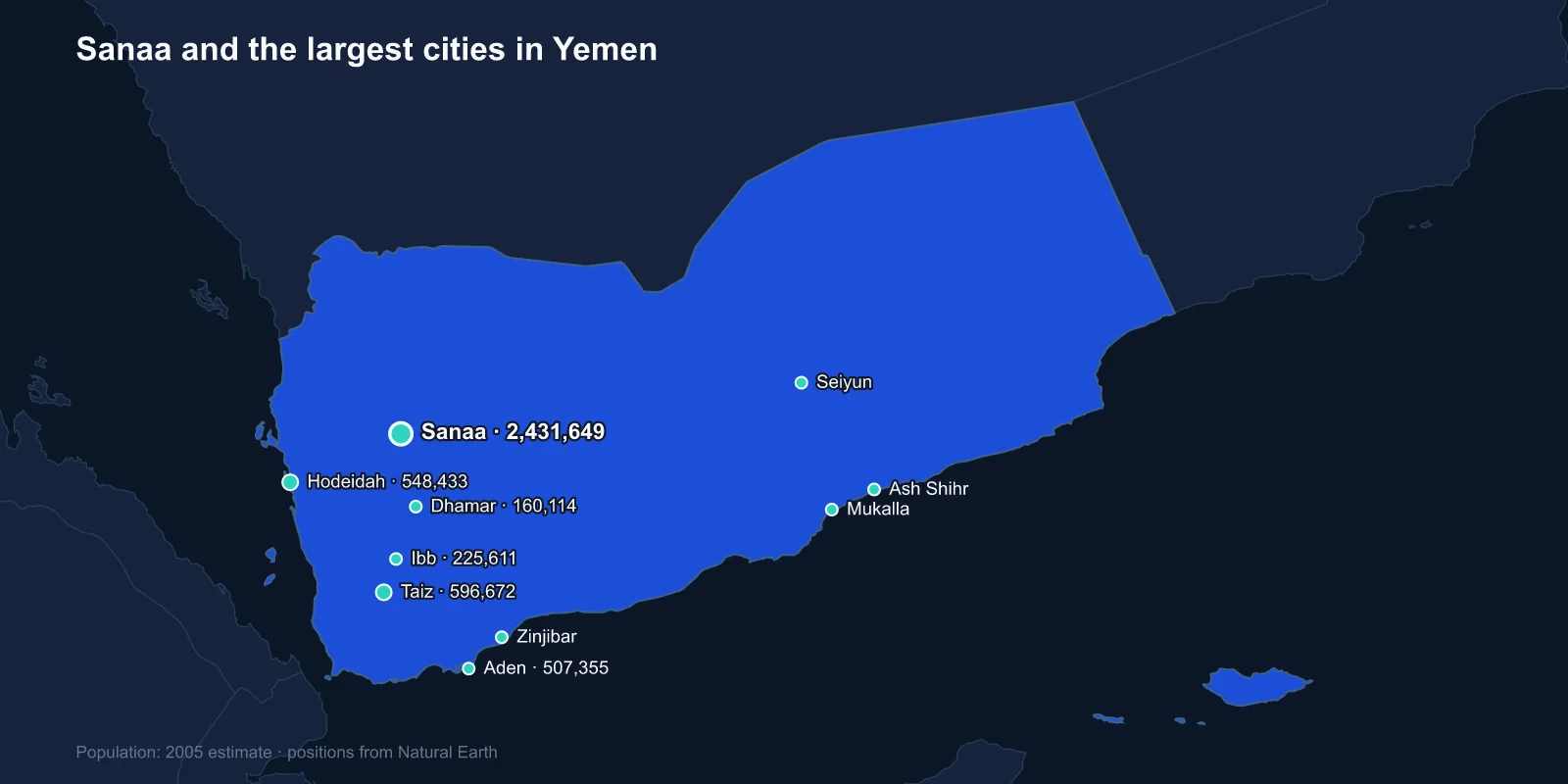
The largest cities in Yemen are Sanaa (about 2,431,649), Taiz (596,672), Hodeidah (548,433), Aden (507,355), Ibb (225,611), Dhamar (160,114), Mukalla (144,137), Seiyun (120,137), Zinjibar (70,801) and Ash Shihr (68,313). These figures are 2005 estimates built on the 2004 census, the last complete count Yemen has conducted.
They describe a country that has since been through a revolution, a civil war and one of the world's worst humanitarian emergencies. Read them as a record of the pre-war distribution rather than as a guide to where Yemenis are now.
A Capital Above Two Thousand Metres
Sanaa sits in a highland basin at roughly 2,250 metres, ringed by mountains, and the altitude explains a great deal about it. The climate is temperate rather than Arabian, agriculture on the surrounding terraces is viable, and the city has been continuously inhabited for well over two thousand years.
Its old city is a UNESCO World Heritage Site and one of the most distinctive urban landscapes anywhere: tower houses of five to nine storeys built from rammed earth and fired brick, their upper floors decorated with white gypsum tracery around the windows, packed into a walled quarter with gardens threaded between the blocks.
Yemeni tradition holds that the city was founded by Shem, son of Noah, which would make it among the oldest in the world. The archaeology is less romantic but still puts substantial settlement there well before the Christian era, when Sanaa was a centre of the Himyarite kingdom.
Aden Has the Harbour
Aden's significance is entirely geographic. It sits in the crater of an extinct volcano on a peninsula commanding the approach to the Bab al-Mandab, the strait between Arabia and Africa that controls the entrance to the Red Sea and, since 1869, the route to the Suez Canal.
The British took Aden in 1839 and held it for 128 years. It became a coaling station and then a bunkering port, and by the 1950s it was one of the busiest harbours in the world, handling thousands of ships a year on the route between Europe and Asia.
That traffic collapsed when the Suez Canal closed in 1967 following the Six-Day War, just as Britain withdrew. Aden became the capital of the People's Democratic Republic of Yemen, the only Marxist state in the Arab world, and the port never fully recovered its position even after the canal reopened.
Two Countries That Unified in 1990
The Sanaa-Aden rivalry is not an invention of the current war. North Yemen and South Yemen were separate states until May 1990, with different colonial histories, different legal systems and, in the South's case, a Soviet-aligned government.
Unification brought the two capitals into one country with Sanaa as the political centre and Aden designated the economic one. A southern attempt to secede in 1994 was defeated militarily, and southern grievance over the settlement that followed has been a live political force ever since.
When the Houthis took Sanaa in September 2014 and the internationally recognised government relocated, it went to Aden. The country reverted, in practice, to the division it had before 1990 — and the Southern Transitional Council has since pressed openly for formal separation.
Taiz, the City in the Middle
Taiz is the second-largest city and sits on the slopes of Jabal Sabir in the southern highlands, historically the most densely populated and most agriculturally productive part of the country. It has a reputation as Yemen's cultural and intellectual centre, and it supplied a disproportionate share of the professional class of both states.
Its position between the Houthi-held highlands and the government-held south has made it the most persistently contested city of the war. Taiz has been besieged, shelled and divided since 2015, with front lines running through neighbourhoods and supply routes cut for years at a time.
Coffee is the other thing Taiz is known for. The port of Mocha, on the Red Sea coast below it, gave its name to the drink, and the beans shipped through it in the seventeenth and eighteenth centuries were the first coffee most Europeans ever tasted.
Hodeidah and the Lifeline
Hodeidah is the main Red Sea port and, for most of the war, the single most important place in Yemen. Something in the order of seventy per cent of the country's imports — food, fuel and medicine for a population that imports the large majority of what it eats — came through its docks.
That made it a military objective and a humanitarian red line simultaneously. A coalition offensive towards the city in 2018 prompted warnings that closing the port would push millions into famine, and the resulting Stockholm Agreement in December 2018 was the war's only substantial negotiated outcome, freezing the front line around the city.
The port has continued to operate under inspection arrangements, intermittently disrupted. Yemen's food security has depended on that single set of cranes for a decade.
The Hadhramaut and the Mud Skyscrapers
Mukalla, on the southern coast, and Seiyun, inland, are the principal towns of the Hadhramaut — a vast eastern region of desert plateau cut by a deep wadi system, historically more connected to the Indian Ocean than to the rest of Yemen.
Hadhrami merchant families emigrated across the monsoon world for centuries, settling in Indonesia, Malaysia, Singapore, India and East Africa. The Bin Laden construction dynasty of Saudi Arabia originates there, as do prominent families across Southeast Asia.
The region's most famous site is Shibam, a walled town in the wadi where tower houses of mud brick rise to eleven storeys, built tightly together on a plinth above the flood plain. It has been described since the 1930s as the Manhattan of the desert, and it is a UNESCO World Heritage Site. Nothing else quite like it exists.
Ibb, Dhamar and the Terraced Highlands
Ibb and Dhamar sit on the highland road between Sanaa and Taiz, in country that receives enough monsoon rain to support intensive agriculture. Ibb province is sometimes called the green province, and the hillsides around both towns are terraced in a system that has been maintained for well over a thousand years.
Those terraces are one of the great engineering achievements of the Arabian peninsula, and they are failing. Maintaining stone retaining walls requires continuous labour, and war, emigration and the shift of agricultural effort towards qat have left many of them to collapse, taking the soil with them.
The Crop That Drinks the Water
No account of Yemeni cities can skip qat. The mildly stimulant leaf is chewed by a large majority of adult men through the afternoon, and its cultivation has expanded enormously because it is the most profitable crop available to highland farmers.
It is also extremely thirsty, and it is irrigated from groundwater. Sanaa sits above an aquifer that has been pumped far beyond its recharge rate for decades, with the water table falling by metres a year, and the city has repeatedly been described as a candidate for the first modern capital to run out of water.
A highland capital of several million people dependent on a depleting aquifer, in a country that imports most of its food, is a structural problem that will outlast the war.
Why the Figures Are Twenty Years Old
Yemen's last census was 2004. A count planned for 2013 was overtaken by the political transition that followed the 2011 uprising, and nothing has been possible since 2014.
What is known is that displacement has been vast. Millions of people have been forced from their homes, many repeatedly, and cities in relatively secure areas — Aden, Mukalla, Marib in particular — have absorbed populations far beyond anything the 2005 figures suggest. Marib, a small desert town before the war, is widely reported to have grown many times over as displaced families gathered there.
Any ranking of Yemeni cities today is therefore a historical document. The order at the top is probably still right; almost everything else has moved.
Socotra, and the Island Nobody Counts
Yemen's most internationally recognised place does not appear on any city list. Socotra lies about 380 kilometres off the Horn of Africa, closer to Somalia than to the Yemeni mainland, and its isolation has produced a flora found nowhere else — roughly a third of its plant species are endemic, including the dragon's blood tree with its upturned umbrella crown.
Hadibu, the main town, holds only a few thousand people. The island was inscribed as a UNESCO World Heritage Site in 2008 and has been largely spared the fighting, though it has been drawn into the political contest between the recognised government and the Southern Transitional Council, and Emirati influence there has grown considerably.
The Highland and the Harbour
Yemen's cities divide along the country's oldest fault line: a highland capital in a fertile basin, a volcanic port commanding one of the world's critical straits, a Red Sea harbour that feeds everyone, and an eastern region that has always faced out to sea.
Quite how far Aden sits from the rest of the Arab world, and which continent Yemen belongs to at all, is picked apart in is Yemen in Asia or Africa. The tower houses of the other capital are the subject of the Sanaa profile, and the highlands and deserts between them are covered in our Yemen country guide.
