
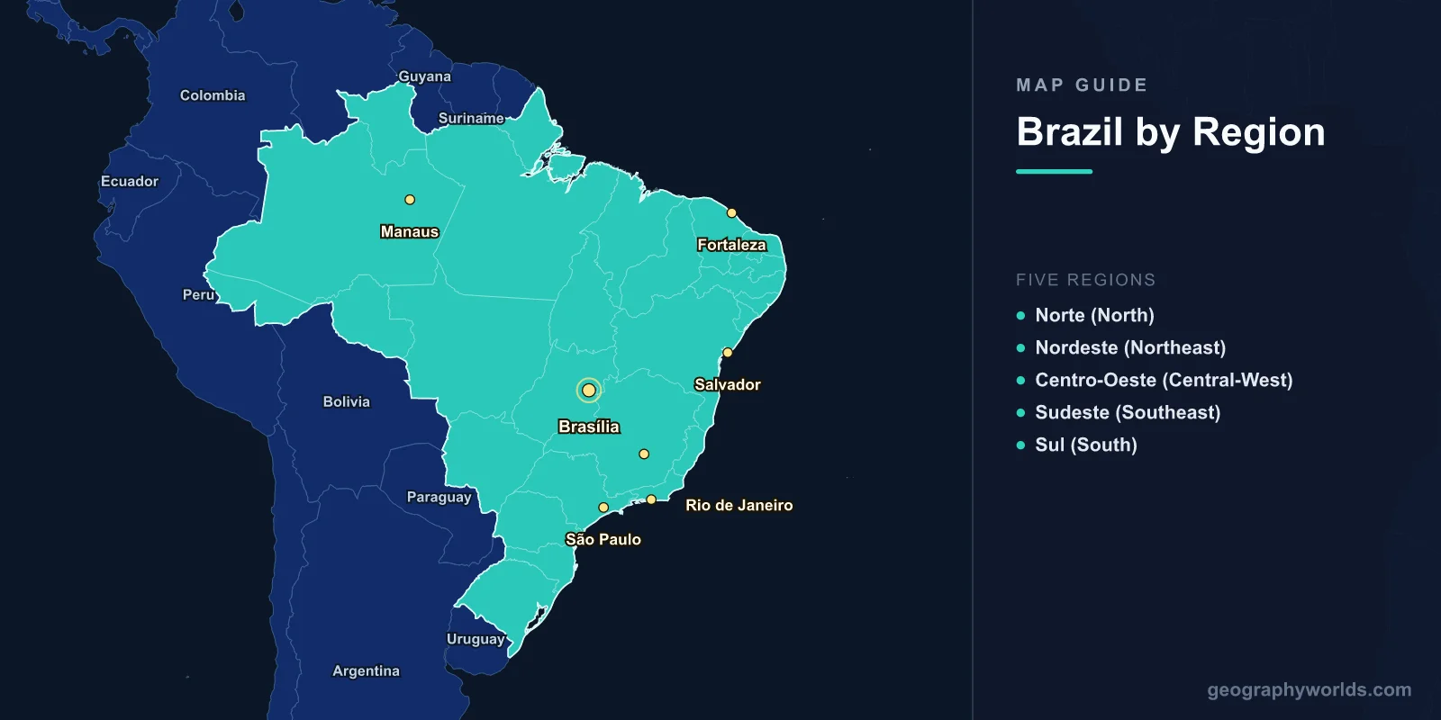
A map of Brazil shows the fifth-largest country on Earth, covering 8,515,767 km2—nearly half of South America. With a population of 214 million across 26 states and a Federal District, Brazil's map reveals extraordinary geographic diversity: the Amazon rainforest (the world's largest tropical forest) in the north, the cerrado savanna in the central plateau, the Atlantic Forest along the coast, the Pantanal wetland (the world's largest tropical wetland) in the west, and the semi-arid caatinga in the northeast. Brazil shares borders with every South American country except Chile and Ecuador.
Geography of Brazil
Brazil spans from 5°N to 33°S latitude, crossing the equator in its northern region. The country is bounded by the Atlantic Ocean to the east (7,491 km of coastline), and shares borders with ten countries: French Guiana, Suriname, Guyana, Venezuela, Colombia, Peru, Bolivia, Paraguay, Argentina, and Uruguay.
The landscape is dominated by two main features: the Amazon Basin in the north and the Brazilian Highlands (Planalto Brasileiro) in the center and south. The Amazon Basin covers approximately 3.6 million km2 of Brazilian territory—an area larger than the entire European Union. The Brazilian Highlands, an ancient shield of metamorphic and igneous rock, average 200–800 m in elevation and include the Serra do Mar and Serra da Mantiqueira coastal ranges.
The Amazon River, the world's largest by volume (discharging 209,000 m3/s into the Atlantic—about 20% of all river water entering the oceans), flows 6,400 km across northern Brazil. Other major rivers include the Paraná (forming the border with Paraguay and feeding the Itaipu Dam), the São Francisco (2,914 km, the "river of national unity" flowing through the semi-arid northeast), and the Tocantins-Araguaia system.
Brazil's highest peak is Pico da Neblina at 2,994 m, near the Venezuelan border in the far north—not in the highlands as one might expect. The country's terrain is generally not extremely mountainous; the highest ranges along the southeastern coast rarely exceed 2,800 m.

26 States & Five Regions
Brazil's 26 states and one Federal District (Brasília) are grouped into five official geographic regions:
- Norte (North): 7 states (Amazonas, Pará, Acre, Rondônia, Roraima, Amapá, Tocantins). The largest region by area (3.85 million km2, 45% of Brazil) but least populated. Dominated by the Amazon rainforest. Manaus and Belém are the major cities.
- Nordeste (Northeast): 9 states (Bahia, Pernambuco, Ceará, Maranhão, Paraíba, Rio Grande do Norte, Alagoas, Sergipe, Piauí). Brazil's most culturally distinct region with African and indigenous influences. Semi-arid caatinga interior (sertão); tropical coast. Salvador, Recife, and Fortaleza are major cities.
- Centro-Oeste (Central-West): 3 states (Goiás, Mato Grosso, Mato Grosso do Sul) plus the Federal District. Cerrado savanna and the Pantanal wetland. Brazil's agricultural frontier—leading producer of soybeans and cattle. Brasília, the planned capital, is here.
- Sudeste (Southeast): 4 states (São Paulo, Rio de Janeiro, Minas Gerais, Espírito Santo). Brazil's economic powerhouse—65% of GDP. Contains the three largest metropolitan areas (São Paulo, Rio, Belo Horizonte). Mountainous terrain with Atlantic Forest remnants.
- Sul (South): 3 states (Paraná, Santa Catarina, Rio Grande do Sul). Subtropical climate; strong European immigrant heritage (Italian, German, Polish). Iguaçu Falls on the Argentine border. Most developed agricultural region with temperate crops.
Major Cities
- São Paulo: 12.3 million (city), 22 million (metro). Largest city in the Southern Hemisphere and South America's financial capital. Located on a plateau at 760 m elevation.
- Rio de Janeiro: 6.7 million (city), 13.5 million (metro). Iconic coastal setting between Sugarloaf Mountain, Corcovado (Christ the Redeemer), and Guanabara Bay.
- Brasília: 3 million (metro). Planned capital inaugurated in 1960, designed by Oscar Niemeyer and Lúcio Costa. Located on the central plateau at 1,172 m. UNESCO World Heritage Site.
- Salvador: 2.9 million. Capital of Bahia; first capital of colonial Brazil. Major center of Afro-Brazilian culture.
- Fortaleza: 2.7 million. Northeastern coast; major tourist destination and growing tech hub.
- Manaus: 2.2 million. Heart of the Amazon; located at the Meeting of the Waters where the Rio Negro and Solimões merge to form the Amazon River.
- Belo Horizonte: 2.5 million. Capital of Minas Gerais; third-largest metro area.
Biomes & Climate
Brazil contains five major biomes, each with distinct geographic and climatic characteristics:
- Amazon Rainforest: Covers 49% of Brazil. Equatorial climate with 2,000–3,000 mm annual rainfall. Average temperature 25–28°C year-round. Contains an estimated 10% of all species on Earth.
- Cerrado: Tropical savanna covering 22% of Brazil. Distinct wet (October–March) and dry (April–September) seasons. Biodiversity hotspot with over 12,000 plant species, many endemic.
- Atlantic Forest (Mata Atlântica): Once covered 1.3 million km2 along the coast; now reduced to about 12% of original extent. Extremely biodiverse with high endemism. Subtropical to tropical climate.
- Caatinga: Semi-arid scrubland of the northeast interior. 250–800 mm annual rainfall, highly seasonal. Adapted thorny vegetation and unique fauna.
- Pantanal: World's largest tropical wetland at 150,000 km2, mostly in Mato Grosso do Sul. Floods seasonally (80% submerged in the wet season). Extraordinary wildlife density—home to jaguars, giant otters, hyacinth macaws.
Key Facts About the Map of Brazil
- Brazil is the fifth-largest country by area (8.5 million km2) and population (214 million).
- The Amazon River discharges more water than the next seven largest rivers combined.
- Brazil shares borders with 10 of South America's 12 countries (all except Chile and Ecuador).
- The country spans three time zones (four when including offshore islands).
- Brazil contains approximately 12% of the world's fresh water.
- The Pantanal is the world's largest tropical wetland at 150,000 km2.
- São Paulo's metro area (22 million) is the most populous in the Southern Hemisphere.
Final Thoughts
The map of Brazil reveals a continental-scale country of staggering geographic diversity. From the world's largest rainforest to its largest tropical wetland, from semi-arid scrublands to subtropical highlands, Brazil encompasses almost every tropical and subtropical landscape type. Its 26 states span five distinct biomes and three time zones, while its cities range from the planned modernist capital of Brasília to the colonial heritage of Salvador and the mega-metropolis of São Paulo. Understanding Brazil's geography is essential for studying global ecology, climate change, and the development challenges facing South America's largest nation.
Test Your Geography Knowledge!
Think you know your maps? Try our interactive geography games!
Play Geography Games →