
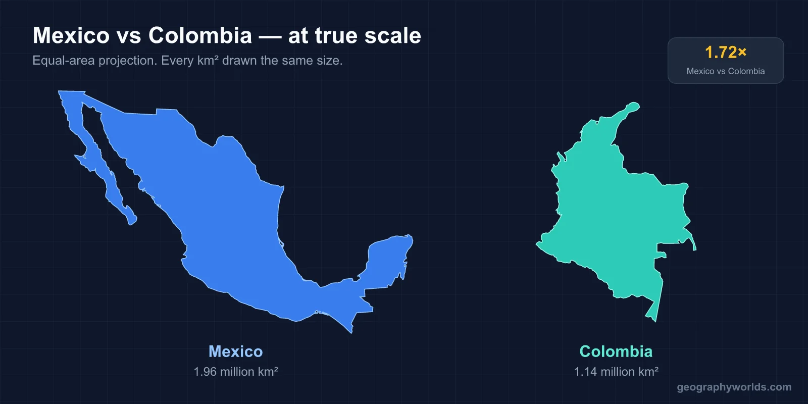
Mexico is the larger, more populous and richer of the two. It covers 1,972,550 km² against Colombia's 1,141,748 km², about 1.7 times the area. It had roughly 134.4 million people in 2026, according to Mexico's National Population Council, while Colombia had about 52.7 million in 2024. The IMF's 2026 estimates put nominal GDP per person at around US$15,800 in Mexico and US$10,100 in Colombia. The capitals are Mexico City and Bogotá, and Spanish is the main language of both. Mexico recognises 68 Indigenous languages as national languages, and Colombia recognises Creole, English and 64 other languages in their regions. Both countries were Spanish viceroyalties, both began their independence struggles in 1810, and both lost land in the 19th and early 20th centuries in ways tied to the United States.
| Mexico | Colombia | |
|---|---|---|
| Area | 1,972,550 km² | 1,141,748 km² |
| Population | about 134.4 million (2026 estimate) | about 52.7 million (2024 projection) |
| Capital | Mexico City, at 2,240 m | Bogotá, at 2,640 m |
| Highest point | Pico de Orizaba, 5,636 m | Pico Cristóbal Colón, reported at 5,775 m |
| Independence began | 16 September 1810 | 20 July 1810 |
| Current constitution | 1917 | 1991 |
| System | Federal republic, 31 states plus Mexico City | Unitary republic, 32 departments plus Bogotá |
| Currency | Mexican peso | Colombian peso |
Tenochtitlan in 1521, Bacatá in 1538: Two Conquests, Two Viceroyalties
Both countries began their colonial history by building a Spanish capital on top of an Indigenous one. In Mexico, an alliance of Spaniards and Indigenous peoples defeated the Aztec Empire in 1521. Hernán Cortés named the territory New Spain and raised Mexico City on the ruins of Tenochtitlan, the Aztec capital in the Valley of Mexico. The Spanish Crown then made New Spain a viceroyalty in 1535, the first it created in the Americas, and appointed Antonio de Mendoza as viceroy.
Colombia's conquest came from the coast inland. Alonso de Ojeda, who had sailed with Columbus, reached the Guajira Peninsula in 1499. The first permanent settlement was Santa Marta in 1525, and Pedro de Heredia founded Cartagena on 1 June 1533. Three expeditions then pushed into the Andes and met in the lands of the Muisca, who farmed the high plateau and traded salt, emeralds and gold. Gonzalo Jiménez de Quesada founded Santa Fe de Bogotá on 6 August 1538. Its name comes from Bacatá, a nearby Muisca settlement.
Here is the first divergence. Mexico City was a viceregal capital for almost three centuries. Bogotá, by contrast, answered to the Viceroyalty of Peru until the Viceroyalty of New Granada was created in 1717, suppressed, and finally re-established in 1739.
1810 in Dolores and in Bogotá: Same Year, Different Wars
Napoleon's invasion of Spain in 1808 set off a crisis of authority across the empire, and both colonies moved in 1810. In Colombia, a junta formed in Santa Fe de Bogotá on 20 July 1810, overthrew the viceroy and claimed to govern New Granada. In Mexico, the priest Miguel Hidalgo y Costilla rang the church bell in the town of Dolores on 16 September 1810 and called his parishioners to arms.

The two wars then took different shapes. Mexico's lasted eleven years as a string of regional uprisings and civil conflicts. It ended in September 1821 with a declaration of independence and a short-lived empire under Agustín de Iturbide. Colombia's revolutionaries were split between federalists and centralists, and a Spanish reconquest overran them. Independence was won from outside. Simón Bolívar led an army from the Venezuelan plains over the Andes, and the Battle of Boyacá on 7 August 1819 decided the campaign. That same year, the Congress of Angostura created Gran Colombia, a union of present-day Colombia, Venezuela, Ecuador and Panama, with Bolívar as president.

The two new states recognised each other quickly. On 10 October 1821, Gran Colombia became the first Latin American country to recognise Mexico's independence, and the two had resident embassies in each other's capitals by 1831. Gran Colombia itself did not last. It was dissolved in 1831, and the core around Bogotá became the Republic of New Granada.
Liberals Against Conservatives: The Reform War and the Thousand Days' War
For most of the 19th century, both countries were divided by the same quarrel. Conservatives wanted a strong centre, a privileged Catholic Church and a limited franchise. Liberals wanted secular schools, weaker church and army privileges and, often, more power for the regions.
In Mexico, the quarrel peaked early. The liberal Constitution of 1857 set out to sell off church property and separate church and state, and it led to the Reform War of December 1857 to January 1861. Conservatives then backed a French intervention that installed the Habsburg archduke Maximilian as emperor. Republican forces under Benito Juárez overthrew him in 1867. After that, the liberals won outright, and the long rule of Porfirio Díaz (1876–1911) followed.
Colombia swung back and forth instead. Liberals reformed its constitution in 1853, and the Rionegro constitution of 1863 renamed the country the United States of Colombia, a federation of nine "sovereign states". Then the 1886 constitution reversed course with a centralised Republic of Colombia, the name it still has. The conflict stayed armed. The Thousand Days' War (October 1899 to November 1902) between the Liberal Party and the government cost an estimated 100,000 to 180,000 lives, the deadliest civil war in Colombia's history. A second round, La Violencia, began with the assassination of the Liberal leader Jorge Eliécer Gaitán on 9 April 1948 and killed at least 200,000 people in ten years.
1848 and 1903: Losing Territory as the United States Expanded
Both countries lost territory in episodes that involved the United States. For Mexico, the loss was enormous. The Mexican–American War of 1846–1848 ended with the Treaty of Guadalupe Hidalgo, signed on 2 February 1848. Mexico ceded 55 percent of its territory, including present-day California, Nevada and Utah, most of Arizona, and parts of New Mexico, Colorado and Wyoming. It also gave up its claim to Texas and accepted the Rio Grande as the border. The United States paid US$15 million, and the Gadsden Purchase of 1853 moved the border further south.
Colombia's loss came through secession. Panama had always been loosely tied to Bogotá, with no practical overland route between them. When the Colombian Congress rejected a treaty letting the United States take over the canal project, Panamanian separatists declared independence on 3 November 1903 with American backing. The United States was the first country to recognise the new republic, and it signed the canal treaty with Panama instead. The secession fixed Colombia's present borders.
The PRI's 71 Years and Colombia's National Front
The 20th century brought each country a political arrangement designed to prevent the next civil war. The Mexican Revolution, from 20 November 1910 to 1920, overthrew Díaz, destroyed the old federal army, produced the Constitution of 1917 that is still in force, and killed around one million people. Its victors founded the party that became the Institutional Revolutionary Party (PRI) in 1946. The PRI held the presidency without a break from 1929 to 2000. Every senator was a PRI member until 1976 and every state governor until 1989.
Colombia's answer to La Violencia was a pact between its two old parties. After General Gustavo Rojas Pinilla seized power in a 1953 coup and ruled as a military dictator until 1957, Conservative and Liberal leaders agreed to the National Front. From 1958 to 1974 they alternated the presidency every four years and split all other elected offices equally. The pact ended the partisan killing but kept other movements out of power. The FARC guerrilla army formed in 1964, and the M-19 formed after the disputed 1970 election.
This is the widest divergence in the two histories: Mexico spent the century under one dominant party, while Colombia kept competitive civilian elections alongside a guerrilla war that, from the mid-1970s, became tangled with the cocaine trade.
NAFTA, the Havana Accord and Where the Paths Stand Now
The 1990s set both countries' current course. Mexico signed the North American Free Trade Agreement, which took effect in 1994 and tied its economy more closely to the United States and Canada. In 2000, the PRI lost the presidency for the first time. Mexico is now the 13th-largest economy in the world by nominal GDP. Since 2006, violence between drug-trafficking groups has caused an estimated 127,000 deaths.
Colombia replaced its 1886 constitution with the Constitution of 1991, written during a wave of violence by guerrillas, paramilitaries and cartels. Peace talks with the FARC began in Havana in 2012. Voters narrowly rejected the first agreement in a referendum on 2 October 2016, by 50.2 percent to 49.8 percent. A revised accord was signed on 24 November 2016, and Congress ratified it on 29 and 30 November, formally ending the conflict with the FARC.
Their economies still show the split. Mexico's is built on manufacturing for North America. Colombia's leans on coal and oil, which made up more than 40 percent of exports in 2020, and on agriculture. It is one of the world's five largest coffee producers, its largest producer of emeralds, and the second-largest exporter of flowers after the Netherlands. With Venezuela, Mexico and Colombia formed the Group of Three trade pact in 1989, which took effect in 1995. On 28 April 2011, they joined Chile and Peru in the declaration that created the Pacific Alliance.
The Andes and the Valley of Mexico: Geography That Shaped Both Paths
Geography runs through all of this. Both capitals sit high on plateaus. Mexico City is at 2,240 m in the Valley of Mexico, and Greater Mexico City had about 21.8 million people. Bogotá is at 2,640 m on the Bogotá savanna, and no urban area is both higher and more populous. But Mexico is dominated by a single central basin, while Colombia is split by three Andean ranges running north to south. The Cordillera Occidental, Central and Oriental are separated by the Cauca and Magdalena valleys, and there are separate Caribbean and Pacific lowlands. The nine eastern lowland departments of the Llanos and the Amazon cover about 54 percent of Colombia's area but hold less than 6 percent of its people. For more on the country's shape and neighbours, see the countries that border Colombia. For its capital in detail, see Bogotá, capital of Colombia.
Mexico's height record belongs to Pico de Orizaba, a dormant volcano at 5,636 m on the Veracruz–Puebla border. It is the highest volcano in North America. Colombia's highest peaks, Pico Cristóbal Colón and Pico Simón Bolívar, are almost equal in height. They stand in the Sierra Nevada de Santa Marta, a coastal massif near the Caribbean and separate from the Andes. The two capitals' own stories are told in our guide to Mexico City. Both nations were governed from a highland seat outward, a pattern that shaped each of the wars above.