
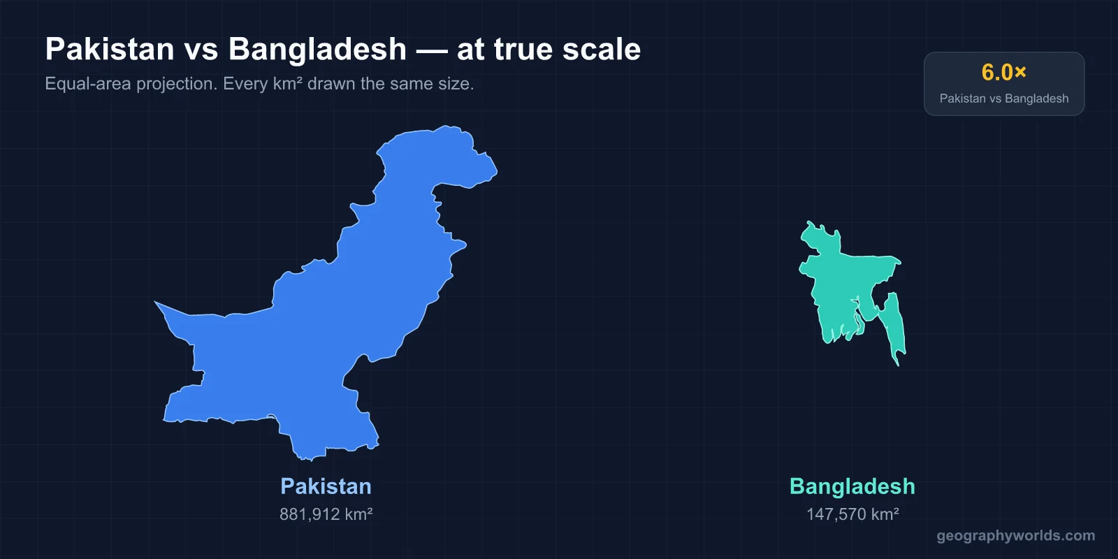
Pakistan is about six times larger and has more people, but Bangladesh is now the richer of the two per person. Pakistan covers 881,913 km² (a figure that includes the Pakistan-administered parts of Kashmir, Azad Kashmir and Gilgit-Baltistan, which India also claims) and counted 241.5 million people in its 2023 census; Bangladesh covers about 148,460 km² and counted 169.8 million in 2022, which makes it one of the most densely settled countries on earth at over 1,100 people per km². On IMF figures, Bangladesh’s GDP per person is about US$2,900 (2026 estimate) against Pakistan’s US$1,700 (2025). Pakistan’s capital is Islamabad and its official languages are Urdu and English, though Punjabi is the most common mother tongue; Bangladesh’s capital is Dhaka and its language is Bengali, spoken by nearly everyone. The two were one country, as West and East Pakistan, from 1947 until 1971, but a traveller moving between them today crosses from high desert and glaciers to a green, waterlogged delta.
From K2 to the Sundarbans: Landscapes at Opposite Extremes
Pakistan is a country of height and dryness. Its northern highlands take in parts of the Hindu Kush, the Karakoram and the Pamir, and they hold five of the world’s fourteen peaks above 8,000 m, among them Nanga Parbat at 8,126 m. K2, at 8,611 m, is the second-highest mountain on earth, and the region’s glaciers are so extensive that it has been called the “Third Pole”. South of the mountains, the Indus River plain carries the farmland of Punjab and Sindh, and to the west the Balochistan Plateau is arid upland. In the southeast, the Thar Desert runs across the border into India.
The most spectacular way into the mountains is the Karakoram Highway, the 1,300 km N-35 from Hasan Abdal in Punjab to the Khunjerab Pass on the Chinese border, which follows the Indus and Hunza valleys past settlements such as Gilgit, Karimabad and Altit.

Bangladesh is the reverse: low, wet and flat. The delta of the Ganges (Padma), Brahmaputra (Jamuna) and Meghna covers about 79 per cent of the country, and most of that plain lies less than 10 m above sea level. Hill ranges cover only about 12 per cent of the country, in the Chittagong Hill Tracts of the southeast and around Sylhet in the northeast; the highest point, Saka Haphong near the Myanmar border, reaches only about 1,064 m. In the southwest the Sundarbans, the world’s largest mangrove forest, spread over about 10,000 km², of which about 6,017 km² lie in Bangladesh’s Khulna Division; it is known for the Bengal tiger, and its three Bangladeshi sanctuaries are listed as UNESCO World Heritage Sites. Down the southeast coast, Cox’s Bazar Beach runs about 120 km, the longest natural sea beach in Asia.

When to Go: Karachi’s 318 mm of Rain against Dhaka’s 1,990 mm
Both countries are ruled by the South Asian monsoon, but they receive it in very different doses. On 1991–2020 averages, Karachi gets about 318 mm of rain in a year, more than half of it in July and August. Dhaka gets about 1,990 mm, and in July alone about 391 mm, more than Karachi’s whole annual total. Most of Bangladesh receives at least 2,300 mm a year, and the northeast around Sylhet receives the most, which is why the country floods every monsoon.
For a visitor, that sets the calendar. In Bangladesh the comfortable months are the dry winter, roughly November to February, when Dhaka’s average January high is about 25 °C and rain almost stops. From March to May, highs near 34 °C come with violent thunderstorms that local English speakers call northwesters, and from June to October the monsoon soaks the delta.
Pakistan needs two calendars. In the plains, June is the month to avoid: the mean temperature in the plains is about 38 °C, and the highest readings can exceed 53 °C. Jacobabad in upper Sindh is one of the hottest cities on earth and has several times passed a wet-bulb temperature of 35 °C, beyond which the human body cannot cool itself. Punjab winters are cool, with January minimums around 4 °C. The mountains run the other way: the Karakoram is at its most accessible in summer, while winter brings heavy snow and sub-zero temperatures across the far north.
Karachi, Lahore and Islamabad against Dhaka and Chittagong
Pakistan’s cities are spread out along the Indus corridor. Karachi, on the Arabian Sea, is the largest city with more than 20 million people and was the federal capital from 1947 to 1959; it is the country’s port and financial centre. Lahore, capital of Punjab with over 14 million, is the historic heart of the region: the Badshahi Mosque, built by the Mughal emperor Aurangzeb between 1671 and 1673, faces the Lahore Fort across the edge of the Walled City. Islamabad is a planned capital laid out to a master plan by the Greek architect Constantinos Doxiadis near Rawalpindi, with a city population of about 1.1 million. Its Faisal Mosque, begun in 1976 to a design by the Turkish architect Vedat Dalokay, stands against the Margalla Hills.
Older than any of these is Mohenjo-daro in Larkana District of Sindh, built around 2500 BCE as one of the largest cities of the Indus Valley Civilisation and home to at least 40,000 people before it was abandoned around 1700 BCE. Rediscovered in the 1920s, it became a UNESCO World Heritage Site in 1980, the first in South Asia. Its grid of baked-brick streets, drains and the Great Bath survive as one of the oldest planned townscapes in South Asia.
Bangladesh concentrates on one city. Dhaka, on the Buriganga and neighbouring rivers of the delta, has an estimated 36.6 million people in its urban area and is widely considered the most densely populated built-up area in the world. Its old city holds the Mughal-era Lalbagh Fort. Chittagong, officially Chattogram, is the second city and the main seaport, a harbour that appears on Ptolemy’s world map. In Khulna Division, the Mosque City of Bagerhat and its Sixty Dome Mosque, built by Khan Jahan in the Bengal Sultanate period, form a second UNESCO site within reach of the Sundarbans. More on the capital is in our guide to Dhaka, capital of Bangladesh.
Sindhi Biryani, Kunna Gosht and Shorshe Ilish
Food follows the land. Pakistan’s wheat-growing Punjab and pastoral north and west produce a cuisine built on meat and bread. Sindhi biryani, a spiced meat-and-rice dish from Sindh, is one of the most eaten dishes in the country. The Potohar Plateau around Rawalpindi is known for kunna gosht, mutton slow-cooked in a clay pot, and hareesa, a smooth blend of wheat, lentils and meat, eaten with sesame-topped roghni naan. Central Punjab pairs saag, mustard greens cooked slowly in ghee, with makai roti made from maize flour, and serves pulao with chicken, mutton or beef. Nihari, a slow-cooked meat stew first eaten as a morning meal at the Mughal courts, is a Punjabi staple alongside haleem and karahi gosht.
Bangladesh’s cuisine comes from rice paddies and rivers. Rice and fish are the everyday base, and the ilish, or hilsa, a herring that runs up the delta’s rivers to spawn, is the national fish. Shorshe ilish, hilsa cooked in a mustard gravy, is widely regarded as the national dish. Desserts, once made mostly from rice paste and jaggery, turned under Mughal influence toward milk, cream, sugar, cardamom and saffron.
Urdu, Punjabi and the Bengali Language Movement of 1952
Language is the clearest thing a traveller notices, and it is also the issue that split the two countries. Pakistan is multilingual, with over 70 languages spoken as first languages. Urdu is the national language and the lingua franca, shared as an official language with English, yet in the 2023 census only about 9.25 per cent of Pakistanis reported it as their mother tongue. Punjabi is the most widely spoken first language, at about 37 per cent, followed by Pashto, Sindhi, Saraiki and Balochi, each with millions of speakers.
Bangladesh is almost the opposite: about 99 per cent of its people are ethnic Bengalis, and Bengali is the single state language. That unity was forged in opposition. In 1948 the new government of Pakistan declared Urdu the sole federal language, though East Bengal, with a Bengali-speaking majority, held most of the country’s people. Protests grew into the Bengali Language Movement, and on 21 February 1952 police action against students protesting at the University of Dhaka left demonstrators dead. The date, Ekushey February, is now Language Movement Day in Bangladesh and, worldwide, International Mother Language Day.
East and West Pakistan, 1947 to 1971
For 24 years the two were one state, with its eastern wing separated from the western by the whole width of northern India. East Pakistan held about 55 per cent of Pakistan’s population, but power, the army and the capital sat in the west. Grievances over language, investment and representation came to a head after the 1970 election. The Pakistani army launched Operation Searchlight in March 1971, independence was proclaimed on 26 March, and after a nine-month war in which India intervened, Pakistani forces surrendered in Dhaka on 16 December 1971, now Victory Day in Bangladesh.
The divergence since then has been economic as much as political. Bangladesh became the world’s second-largest garment exporter, with textiles bringing in over 84 per cent of its export earnings. On the IMF’s latest figures it has overtaken Pakistan not only in income per person but in total output too, about US$511 billion (2026) against Pakistan’s US$408 billion (2025), while Pakistan remains the larger and more populous country. For the other borders that shaped the region, see our guides to the India–Pakistan border and to the geography of Bangladesh.